Stuart Range facts for kids


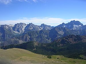
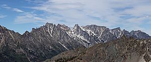
The Stuart Range is a cool mountain range located in central Washington State, USA. It's part of the eastern Cascade Range, found southwest of Leavenworth. This mountain range stretches from east to west.
The western part of the Stuart Range has one sharp ridge. But as you go further east, the range splits into two ridges that run side-by-side. The northern one is called the Enchantment Peaks. In between these two ridges, you'll find the Enchantment Basin. This basin is home to many small, clear mountain lakes called tarns, known as the Enchantment Lakes. Together, this basin and the eastern peaks of the Stuart Range form an amazing area called The Enchantments. It's a very popular spot for people who love to go backpacking and explore the outdoors. South of the Stuart Range, the land drops sharply down to Ingalls Creek. Beyond the creek, you can see the Wenatchee Mountains, which run in a similar direction.
Contents
Exploring the Stuart Range Peaks
The Stuart Range is home to many impressive mountain peaks. Here's a list of some of the most well-known ones, generally listed from west to east.
Western Peaks
These peaks form the single sharp ridge on the western side of the range.
- Mount Stuart - 9,209 feet (2,807 m) - 47°28′30″N 120°54′11″W / 47.4751179°N 120.9031444°W
- Sherpa Peak - 8,478 feet (2,584 m) - 47°28′19″N 120°53′19″W / 47.4720626°N 120.8886996°W
- Argonaut Peak - 8,369 feet (2,551 m) - 47°28′12″N 120°51′41″W / 47.4701186°N 120.8614768°W
- Colchuck Peak - 8,507 feet (2,593 m) - 47°28′37″N 120°50′42″W / 47.4770632°N 120.8450878°W
- Dragontail Peak - 8,809 feet (2,685 m) - 47°28′43″N 120°50′00″W / 47.4787301°N 120.8334210°W
Eastern Peaks of the South Ridge
As the range splits, these peaks are found on the southern of the two ridges.
- Witches Tower - 8,520 feet (2,600 m) - 47°28′36″N 120°49′32″W / 47.476586°N 120.82555°W
- Little Annapurna - 8,458 feet (2,578 m) - 47°28′05″N 120°48′52″W / 47.4681749°N 120.8145314°W
- McClellan Peak - 8,225 feet (2,507 m) - 47°28′11″N 120°47′10″W / 47.4698420°N 120.7861976°W
- Rocket Peak - 7,375 feet (2,248 m) - 47°28′06″N 120°46′13″W / 47.468448°N 120.770185°W
- Gremlin Peak - 7,250 feet (2,210 m) - 47°28′16″N 120°45′50″W / 47.471085°N 120.763839°W
Enchantment Peaks (Eastern Peaks of the North Ridge)
These are the peaks that make up the northern ridge in the eastern part of the range, surrounding the Enchantment Basin.
- Colchuck Balanced Rock - 8,200 feet (2,500 m)+ - 47°29′29″N 120°49′08″W / 47.491451°N 120.818789°W
- Cannon Mountain - 8,579 feet (2,615 m) - 47°30′09″N 120°48′07″W / 47.5026194°N 120.8020322°W
- Enchantment Peak - 8,520 feet (2,600 m)+ - 47°29′15″N 120°48′23″W / 47.487609°N 120.806379°W
- Prusik Peak - 7,858 feet (2,395 m) - 47°29′14″N 120°47′03″W / 47.4873420°N 120.7842537°W
- The Temple - 8,035 feet (2,449 m) - 47°29′25″N 120°46′08″W / 47.4903978°N 120.7689757°W
How the Mountains Were Formed
The Stuart Range sits on top of a huge mass of rock called the Mount Stuart batholith. Imagine a giant blob of melted rock that cooled and hardened deep underground. This batholith is about 13 by 16 miles wide. It's made of two main sections of igneous rock (rock formed from cooled magma), separated by thinner layers of other rocks like Schist and rocks from the Ingalls Complex. The eastern part of this rock mass is about 93 million years old, while the western part is a bit younger, between 83 and 86 million years old. The rocks you see on the surface are mostly types of granite called quartz diorite and granodiorite.
These mountains are located near a convergent plate boundary. This is a place where two of Earth's giant tectonic plates are slowly crashing into each other. In western Washington, the North American plate is sliding over the top of the Juan de Fuca plate. This slow collision causes both volcanoes and earthquakes. This process has been happening for over 200 million years! Over time, the constant pushing and lifting, combined with erosion from wind and water, has brought the hard granite rock of the batholith to the surface. This is why the Stuart Range is one of the most amazing mountain ranges in Washington State.
 | James Van Der Zee |
 | Alma Thomas |
 | Ellis Wilson |
 | Margaret Taylor-Burroughs |


