
McClellan Peak facts for kids
Quick facts for kids McClellan Peak |
|
|---|---|

Southwest aspect, from Earl Peak
|
|
| Highest point | |
| Elevation | 8,364 ft (2,549 m) |
| Prominence | 1,244 ft (379 m) |
| Isolation | 1.34 mi (2.16 km) |
| Parent peak | Little Annapurna (6,376 ft) |
| Geography | |

McClellan Peak
Location in Washington (state)

McClellan Peak
Location in the United States
|
|
| Location | Washington state, U.S. |
| Parent range | Cascade Range |
| Topo map | USGS Enchantment Lakes |
| Climbing | |
| First ascent | July 5, 1946 by Ken Prestrud, Keith Rankin, William Herston |
| Easiest route | class 3 scrambling |
McClellan Peak is a tall mountain, standing 8,364 feet high. You can find it in Chelan County, in Washington state. This peak was named after George B. McClellan, an Army explorer who visited the area in 1853.
McClellan Peak is part of the southern edge of The Enchantments, a beautiful area with many lakes. It's also located within the Alpine Lakes Wilderness. This mountain is part of the Stuart Range, which is a smaller part of the larger Cascade Range. McClellan Peak is about 1.3 miles east of Little Annapurna, which is the closest mountain that is taller than it. Water from rain and melting snow flows from the peak into streams that eventually join the Wenatchee River.
Contents
Understanding the Climate Around McClellan Peak
The weather in the Cascade Range is very interesting. Most of the weather systems start over the Pacific Ocean. They then travel east towards the mountains.
How Mountains Affect Weather
When these weather systems reach the tall peaks of the Cascade Range, they are forced to rise. As the air goes higher, it cools down. This cooling causes the moisture in the air to turn into rain or snow. This process is called orographic lift. Because of this, the Cascade Mountains get a lot of rain and snow, especially in winter.
Seasonal Weather Patterns
During the winter, the weather is usually cloudy. However, in the summer, large areas of high pressure form over the Pacific Ocean. These systems often bring clear skies to the mountains. This means you'll usually see little to no clouds during the summer months.
Snow and Avalanches
Because the weather is influenced by the ocean, the snow in this area tends to be wet and heavy. This type of snow can increase the risk of avalanches, which are dangerous slides of snow down a mountainside.
The Amazing Geology of the Alpine Lakes Wilderness
The Alpine Lakes Wilderness is known for its rugged and dramatic landscape. It has jagged peaks, sharp ridges, and deep valleys carved by glaciers. You'll also see huge granite walls and more than 700 mountain lakes! The way the land looks today was shaped by geological events that happened millions of years ago. These events created the big changes in elevation and led to the different climates across the Cascade Range.
How the Cascade Mountains Formed
The story of the Cascade Mountains began millions of years ago, during a time called the late Eocene Epoch. At that time, the North American Plate (a huge piece of Earth's crust) was slowly moving over the Pacific Plate. This movement caused a lot of volcanic activity, with molten rock rising to the surface.
Also, smaller pieces of Earth's crust, called terranes, crashed into the continent. These collisions helped build up the North Cascades about 50 million years ago.
The Power of Glaciers
During the Pleistocene period, which started over two million years ago, huge sheets of ice called glaciers repeatedly moved across the land. As they advanced and then melted back, they scraped and carved the landscape. They left behind piles of rock and debris.
The last time glaciers retreated from the Alpine Lakes area was about 14,000 years ago. By 10,000 years ago, they had moved north of the Canada–US border. The "U"-shaped valleys you see in the mountains today were formed by these powerful glaciers. The combination of the land being pushed up (uplift), cracks forming in the Earth (faulting), and the work of glaciers created the tall peaks and deep valleys of the Alpine Lakes Wilderness.
Images for kids
-
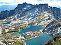
McClellan from Enchantment Peak
-
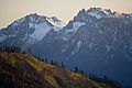
McClellan Peak (left) and The Temple (right)
-
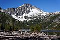
McClellan Peak seen from Upper Snow Lake

.jpg)

