
Witches Tower (Washington) facts for kids
Quick facts for kids Witches Tower |
|
|---|---|

Witches Tower
|
|
| Highest point | |
| Elevation | 8,520 ft (2,600 m) |
| Prominence | 120 ft (37 m) |
| Isolation | 0.39 mi (0.63 km) |
| Parent peak | Dragontail Peak (8,860 ft) |
| Geography | |

Witches Tower
Location in Washington (state)

Witches Tower
Location in the United States
|
|
| Location | Chelan County, Washington state, U.S. |
| Parent range | Cascade Range Wenatchee Mountains Stuart Range |
| Topo map | USGS Enchantment Lakes |
| Type of rock | Granite |
| Climbing | |
| Easiest route | class 3 scrambling |
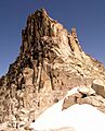
Witches Tower is a tall mountain, about 8,520 feet high. It's made of strong granite rock and is located about 10 miles southwest of Leavenworth in Chelan County, Washington state.
This mountain is part of a beautiful area called The Enchantments, which is inside the Alpine Lakes Wilderness. It's managed by the Okanogan-Wenatchee National Forest, a special protected area. Witches Tower is also part of the Stuart Range, which is a smaller group of mountains within the larger Wenatchee Mountains.
Witches Tower is located about 0.8 miles northwest of Little Annapurna and 0.4 miles east-southeast of Dragontail Peak. Dragontail Peak is its closest and taller neighbor. Around Witches Tower, you can still see parts of the old Snow Creek Glacier. Rain and melting snow from the mountain flow into streams that eventually join the Wenatchee River.
What is the Climate Like at Witches Tower?
The weather around Witches Tower is mostly shaped by the Pacific Ocean. Most weather systems start over the Pacific and move east towards the Cascade Range. As these systems hit the tall Cascade Mountains, they are forced to rise. This causes them to drop their moisture as rain or snow onto the mountains. This process is called Orographic lift.
Because of this, the Cascade Mountains get a lot of rain and snow, especially in winter. During winter, it's often cloudy. But in summer, high-pressure systems over the Pacific Ocean usually bring clear skies. The snow here tends to be wet and heavy because of the ocean's influence, which can sometimes lead to avalanche danger.
How Was Witches Tower Formed?
The area around Witches Tower, known as the Alpine Lakes Wilderness, has very rugged land. You'll find sharp peaks, long ridges, deep valleys carved by glaciers, and huge granite rock walls. There are also over 700 mountain lakes scattered around. All these amazing features were created by big geological events that happened millions of years ago. These events also caused the huge changes in height across the Cascade Range, leading to different climates.
The story of how the Cascade Mountains formed goes back millions of years, to a time called the late Eocene Epoch. At that time, the North American Plate (a huge piece of Earth's crust) was slowly moving over the Pacific Plate. This movement caused many volcanic eruptions and other fiery rock activity. Also, smaller pieces of Earth's crust, called terranes, crashed into North America. These collisions helped build the North Cascades about 50 million years ago.
Later, during the Pleistocene period (which started over two million years ago), huge sheets of ice called glaciers moved across the land many times. As they moved, they scraped and carved the landscape, leaving behind piles of rock. The last time these glaciers retreated from the Alpine Lakes area was about 14,000 years ago. They had moved north of the Canada–US border by 10,000 years ago. The "U"-shaped valleys you see today were carved by these glaciers. The combination of land being pushed up (called uplift) and cracks forming in the Earth (called faulting), along with the glaciers, created the tall peaks and deep valleys of the Alpine Lakes Wilderness.
Images for kids
-
Witches Tower
