
Bonanza Peak (Washington) facts for kids
Quick facts for kids Bonanza Peak |
|
|---|---|

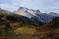
North aspect featuring Company Glacier
|
|
| Highest point | |
| Elevation | 9,516 ft (2,900 m) |
| Prominence | 3,711 ft (1,131 m) |
| Isolation | 13.8 mi (22.2 km) |
| Geography | |

Bonanza Peak
Location in Washington (state)

Bonanza Peak
Location in the United States
|
|
| Location | Glacier Peak Wilderness Chelan County, Washington, U.S. |
| Parent range | North Cascades |
| Topo map | USGS Holden |
| Climbing | |
| First ascent | 1937 by Curtis James and party |
Bonanza Peak is a very tall mountain in the North Cascades mountain range. It's located in the state of Washington, USA, within the Glacier Peak Wilderness area. Standing at about 9,516 feet (2,900 m) (or 2,900 meters) high, it's the tallest point in Chelan County. It's also the highest mountain in Washington that isn't a volcano, and the tallest non-volcanic peak in the entire Cascade Range. Its 'prominence' (how much it rises above the land around it) is 3,711 feet (1,131 m). This makes it the 26th most prominent peak in Washington state. The closest mountain that's even taller is Glacier Peak, which is about 14.4 miles (23.2 km) (or 23 kilometers) to the southwest. Bonanza Peak has three big glaciers on its sides: Company Glacier on the north, Mary Green Glacier on the east, and Isella Glacier on the south.
Mountain History
Bonanza Peak wasn't always called Bonanza Peak! It was first named North Star Mountain. Another smaller mountain nearby was called Bonanza Peak. But in 1904, when the USGS made their first map of the area, they accidentally switched the names. The new names stuck, and that's why we call it Bonanza Peak today.
The first time anyone reached the top of Bonanza Peak was in 1937. The climbers were Curtis I. James, Barrie James, and Joe Leuthold. They were all part of a climbing group called the Mazamas.
Weather and Climate
Since Bonanza Peak is on the east side of the Cascade Range, it gets a bit less rain and snow than the areas to the west. In the summer, it can get warm, and sometimes there are thunderstorms.
Most of the weather that affects the mountain comes from the Pacific Ocean. These weather systems travel northeast towards the Cascade Mountains. When they hit the tall peaks of the North Cascades, the air is forced to rise. As the air goes up, it cools down and drops its moisture as rain or snow onto the mountains. This is called Orographic lift. Because of this, the North Cascades gets a lot of precipitation, especially heavy snowfall in the winter. The water from the mountain's runoff and melting glaciers flows into nearby Lake Chelan through streams like Agnes Creek, Company Creek, and Railroad Creek.
How the Mountains Formed
.jpg)
The North Cascades mountains are known for their very rugged and dramatic landscape. They have sharp, rocky peaks, long ridges, and deep valleys carved by glaciers. The amazing shapes of these mountains and the big changes in elevation were created by geological events that happened millions of years ago. These changes also led to different climates and types of plants in various areas.
The story of how the Cascade Mountains formed goes back millions of years, to a time called the late Eocene Epoch. The North American Plate (a huge piece of the Earth's crust) was slowly moving over the Pacific Plate. This movement caused a lot of volcanic activity. For example, Glacier Peak, a large volcano that is about 14.4 mi (23.2 km) southwest of Bonanza Peak, started forming in the middle of the Pleistocene period. Also, about 50 million years ago, small pieces of the Earth's crust called terranes came together to form the North Cascades.
During the Pleistocene period, which started over two million years ago, huge glaciers repeatedly moved across the land. As they moved, they scraped and shaped the landscape, leaving behind piles of rock and debris. The river valleys in this area often have a "U" shape, which is a clear sign that glaciers once moved through them. The combination of the land being pushed up (called uplift) and cracks forming in the Earth's crust (called faulting), along with the power of glaciers, created the tall peaks and deep valleys we see in the North Cascades today.
Images for kids
-
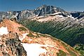
Bonanza from Lyman Lakes area
-
Bonanza and North Star Mountain, from Plummer Mountain


