
Ratchaburi province facts for kids
Quick facts for kids
Ratchaburi
ราชบุรี
|
|||
|---|---|---|---|

Old Ratchaburi Provincial Hall, now Ratchaburi National Museum
|
|||
|
|||
| Nickname(s):
Mueang Ong
(city of jars) |
|||

Map of Thailand highlighting Ratchaburi province
|
|||
| Country | Thailand | ||
| Capital | Ratchaburi | ||
| Area | |||
| • Total | 5,196 km2 (2,006 sq mi) | ||
| Area rank | Ranked 42nd | ||
| Population
(2018)
|
|||
| • Total | 873,518 | ||
| • Rank | Ranked 27th | ||
| • Density | 168/km2 (440/sq mi) | ||
| • Density rank | Ranked 21st | ||
| Human Achievement Index | |||
| • HAI (2017) | 0.5713 "somewhat low" Ranked 53rd |
||
| Time zone | UTC+7 (ICT) | ||
| Postal code |
70xxx
|
||
| Calling code | 032 | ||
| ISO 3166 code | TH-70 | ||


Ratchaburi province (which means 'the land of the king' in Thai) is one of Thailand's 76 provinces. It is located in Western Thailand. This province shares borders with Kanchanaburi province, Nakhon Pathom province, Samut Sakhon province, Samut Songkhram province, and Phetchaburi province. To the west, it also borders the country of Myanmar.
Ratchaburi is about 80 kilometers (50 miles) west of Bangkok, Thailand's capital city. The Tenasserim Hills form a natural border with Myanmar in the west. The Mae Klong River flows right through the middle of Ratchaburi town.
Contents
Exploring Ratchaburi's Geography
Ratchaburi province is a medium-sized area, covering about 5,196 square kilometers (2,006 square miles). It has different types of landscapes.
Eastern Plains and Floating Markets
The eastern part of the province is mostly flat. It has wide river plains from the Mae Klong River. Many small canals, called khlongs, crisscross this area. One of the most famous places here is the Damnoen Saduak Floating Market. Here, you can see vendors selling goods from boats!
Western Mountains and Caves
The western part of Ratchaburi is more mountainous. It includes parts of the Tenasserim Hills. These mountains are mostly made of limestone. Because of this, there are many cool caves to explore.
- Some caves are home to huge groups of bats. It's amazing to watch them fly out in the evening to find food!
- Other caves, like Khao Bin, are open for visitors to explore.
The main river in the western area is the Phachi River. Near this river, you'll find the Chaloem Phrakiat Thai Prachan National Park. This park covers 329 square kilometers (127 square miles). There is also the Mae Nam Phachi Wildlife Sanctuary, which is 489 square kilometers (189 square miles). These areas help protect nature.
Ratchaburi province has three main parts. First, there's the border with Myanmar in the west, which is about 60 kilometers (37 miles) long. Second, there are the Tenasserim mountains and forests, which are about 200–300 meters (650–980 feet) high. Third, the central part of the province has many wetlands because of the rivers. Ratchaburi has lots of natural resources. Forests cover about 1,711 square kilometers (661 square miles), which is 33 percent of the province. It also has minerals like tin, limestone, and quartz.
A Glimpse into Ratchaburi's Past
The history of Ratchaburi city goes back a very long time. It was an important city during the Dvaravati period. This was when the Mon Kingdom was powerful. Near Ratchaburi, you can still see the ruins of an ancient city called Khu Bua. Some stories say Ratchaburi's history goes back even further to a mythical kingdom called Suwannaphum.
Ratchaburi: The King's Land
The name "Ratchaburi" means 'the land of the king'. This name comes from the fact that King Rama I, a very important Thai king, was born here. The city of Ratchaburi is located on the banks of the Mae Klong River. It was once a town of the Suvarnabhumi Kingdom.
Archaeological finds show that people have lived in this area since the Middle Stone Age. An ancient city from the Dvaravati period was found in the Mueang Ratchaburi district.
Ratchaburi as a Frontier City
In the late Ayutthaya period and early Rattanakosin period, Ratchaburi was a very important border city. It was often a place where battles took place. For example, during the time of King Rama I, his army fought the Burmese in the Ratchaburi area many times. One of the most important battles was the Burmese–Siamese War (1785–1786).
Later, in 1817, King Rama II ordered a new city wall to be built on the left bank of the Mae Klong River. This wall is still there today. In 1894, during the reign of King Rama V, the government changed. Many nearby cities, including Ratchaburi, Kanchanaburi, Samut Songkhram, Phetchaburi, Pran Buri, and Prachuap Khiri Khan, were grouped together to form Ratchaburi county.
People and Culture of Ratchaburi
Most of the people in Ratchaburi are Buddhist, making up about 98.3 percent of the population.
Diverse Communities
Ratchaburi is home to different groups of people:
- Hill tribes: Mostly Karen people live near the Myanmar border. They make up about one percent of the population.
- Other groups: There are also smaller groups of Mon, Lawa, Lao, Chinese, and Khmer people living in the province.
Symbols of Ratchaburi Province
Every province in Thailand has special symbols.
- Provincial Seal: The seal of Ratchaburi shows a royal sword above royal sandals on a special tray called a phan. This represents the name Ratchaburi, which means 'city of the king'.
- Provincial Slogan: Ratchaburi's slogan is "Beautiful women of Photharam, exquisite women of Baan Pong, the city of earthenware jars, shadow plays at Wat Khanon, magnificent caves, floating market at Damnoen, bats, delicious Jullien's golden carp". This slogan highlights many of the province's unique features.
- Provincial Flower: The official flower is the Pink Shower Tree (Cassia bakeriana).
- Provincial Tree: The official tree is Wrightia pubescens.
- Provincial Fish: The Jullien's golden carp (Probarbus jullieni) is the provincial fish. This fish was once common in the Mae Klong River and tasted very good. However, it is now critically endangered.
Getting Around Ratchaburi
Rail Travel
The main train station in Ratchaburi is Ratchaburi railway station. This makes it easy to travel to and from the province by train.
Health Services in Ratchaburi
Ratchaburi Hospital is the main hospital in the province. It provides important healthcare services to the people living there.
How Ratchaburi is Governed

Provincial Government Structure
Ratchaburi province is divided into 10 main areas called districts (amphoes). These districts are then split into smaller parts:
- 104 sub-districts (tambons)
- 935 villages (mubans)
Here are the 10 districts:
- Mueang Ratchaburi
- Chom Bueng
- Suan Phueng
- Damnoen Saduak
- Ban Pong
- Bang Phae
- Photharam
- Pak Tho
- Wat Phleng
- Ban Kha
Local Government Bodies
As of November 26, 2019, Ratchaburi has different types of local governments:
- One Ratchaburi Provincial Administration Organisation (ongkan borihan suan changwat).
- 34 municipal (thesaban) areas.
- Ratchaburi, Ban Pong, Tha Pha, and Photharam have town (thesaban mueang) status.
- There are 30 smaller subdistrict municipalities (thesaban tambon).
- Areas not covered by municipalities are managed by 77 Subdistrict Administrative Organisations (SAO).
Understanding the Human Achievement Index (HAI) in Ratchaburi
The Human Achievement Index (HAI) is a way to measure how well people are doing in different areas of life. It looks at eight key areas of human development. Since 2003, this index has helped track progress in Thailand's provinces.
In 2017, Ratchaburi province had an HAI value of 0.5713. This score is considered "somewhat low" and placed Ratchaburi at 53rd in the ranking among provinces.
The HAI ranking helps us understand how provinces are doing in areas like:
- Health
- Education
- Employment
- Income
- Housing
- Family life
- Transportation
- Community participation
Images for kids
-
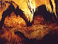
Khao Bin cave
-
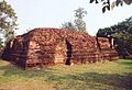
Wat Khlong, the largest ruin of Khu Bua
-
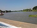
Bus terminal by Mae Klong, Ban Pong
-
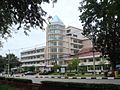
Muban Chombueng Rajabhat University, a branch of Rajabhat University in Chom Bueng
-
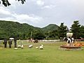
The Scenery Vintage Farm, resort of Suan Phueng
-
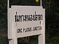
Sign of Nong Pladuk Junction Railway Station, a key train station
-
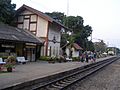
Chet Samian Railway Station, Photharam
-
Ratchaburi Shadow Puppet Museum in Wat Khanon, Photharam
-
Chaloem Phrakiat Rama 9 Road, Ban Pong
-
Corridor of Ratchaburi National Museum


.jpg)
.jpg)


_1.jpg)

.jpg)
See also
 In Spanish: Provincia de Ratchaburi para niños
