Ratodero facts for kids
Quick facts for kids
Ratodero
|
|
|---|---|
|
Sub district
|
|

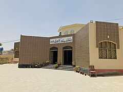
Shah Latif Public Library Ratodero
|
|
| Country | |
| Province | Sindh |
| Area | |
| • Total | 138,002 km2 (53,283 sq mi) |
| Population
(2023 census)
|
|
| • Total | 81,935 |
| Time zone | UTC+5 (PST) |
| Calling code | 074 |
| Number of towns | 60 |
| Number of Union councils | 9 |
| Ratodero Government Website | |
Ratodero (Sindhi: رتوديرو) is a town in Pakistan. It is the main town of Ratodero Taluka. This area is part of Larkana District in the Sindh province. Ratodero is about 28 kilometers (17 miles) from Larkana city.
Since Pakistan became independent, Ratodero has been famous for its delicious sweets. It is also known for special handmade hats called Sindhi topi. Today, the town's main business is growing and processing rice. You will find many rice mills here.
Contents
Exploring Ratodero's Location
Ratodero serves as the administrative center for its Taluka (a type of sub-district). It is located on the main road that connects Larkana to Shikarpur.
Roads Connecting Ratodero
As an important transport hub, many roads lead from Ratodero to nearby towns and villages. These include:
Understanding Ratodero's Population
The population of Ratodero has grown quite a lot over the years. Here is a look at how many people have lived there during different census counts:
| Census Year | Number of People |
|---|---|
| 1972 | 13,292 |
| 1981 | 19,704 |
| 1998 | 40,217 |
| 2017 | 67,502 |
| 2023 | 81,935 |
How Ratodero is Governed
Ratodero Taluka is divided into smaller administrative areas. These are called Union Councils. There are 9 Union Councils in total that help manage the area:
- Behman
- Bunguldero
- Jumo Agham
- Naudero
- Wada Bosan
- Pir Bakhsh Bhutto
- Rarodero-I
- Ratodero-II
- Maso Dero
- Waris Dino Machi
- Ahmed Khan Lashari
- Ahmed Khan Jalbani
- Wazir Khan Jalbani
See also
 In Spanish: Ratodero para niños
 | DeHart Hubbard |
 | Wilma Rudolph |
 | Jesse Owens |
 | Jackie Joyner-Kersee |
 | Major Taylor |


