Rattlesnake Mountain (Benton County, Washington) facts for kids
Quick facts for kids Rattlesnake Mountain |
|
|---|---|

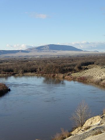
The view of Rattlesnake Mountain from the Horn Rapids Golf Course in Richland.
|
|
| Highest point | |
| Elevation | 3,531 ft (1,076 m) |
| Prominence | 840 ft (260 m) |
| Isolation | 1.55 mi (2.49 km) |
| Parent peak | Lookout Summit |
| Listing | Benton County highest peaks 2nd |
| Geography | |
| Parent range | Rattlesnake Hills |
| Topo map |
|
Rattlesnake Mountain, also known as Lalíik by the Yakama Nation, is a tall, windy mountain in Washington state. Its Native American name, Lalíik, means "land above the water." The mountain stands about 3,531 feet (1,060 meters) high. It looks over the Hanford nuclear site.
Some parts of the western side of the mountain are private ranchland. Other parts, especially on the eastern side, are protected by the government. This protected area is part of the Hanford Reach National Monument. The United States Fish and Wildlife Service manages this land. Rattlesnake Mountain is the second highest point in Benton County, Washington. Only Lookout Summit is a little taller, by about 98 feet (30 meters).
Rattlesnake Mountain is famous for its very strong winds. Winds have been recorded as fast as 150 miles per hour (241 kilometers per hour)!
The History of Rattlesnake Mountain
The Yakama Nation, a Native American tribe, has always called this mountain Lalíik. This name means "land above the water." Some historians think this name might come from a time long ago. During the Missoula Floods, huge floods covered much of the land. Rattlesnake Mountain might have been one of the only places not completely underwater. Water levels could have reached 1,200 feet (366 meters) high.
Scientists have found large rocks, called glacial erratics, on Rattlesnake Mountain. These rocks were carried by the floods to high places. However, there is not much proof that people lived there during those floods, which happened about 12,000 to 13,000 years ago.
Lalíik is a very special and sacred place for many Native American groups. This includes the Nez Perce, Umatilla, Wanapum, Cayuse, Walla Walla, and Yakama tribes. It is still an important spiritual place today.
In 1943, the United States government took control of Rattlesnake Mountain. They used it as a safety zone for the nuclear project at the Hanford site. Later, in 1955, the United States Army built a missile base on the mountain. This base had Nike Ajax missiles. It stayed open until December 1958, when it was closed down.
Rattlesnake Mountain Observatory
The Rattlesnake Mountain Observatory was built on the mountain's top in 1966. It used some of the old missile base buildings. The observatory's main telescope was put in place in 1971. This telescope is 32 inches (0.8 meters) wide. It is inside a large dome that is 24 feet wide. This telescope is the biggest one that is permanently set up in Washington State.
The telescope was used often in the 1970s and early 1980s. But then it was not used as much. Because of its location, it was updated so people could control it from far away. A local group of scientists and engineers from the Pacific Northwest National Laboratory helped run the observatory.
In 2008, the Department of Energy announced that the observatory would have to move. They wanted to return the area to its natural state. This was also because the mountain is a very important cultural site for Native Americans. The observatory began moving in May 2009. Most of the move, including the telescope, was finished by June of that year. By late 2012, the telescope had a new home. It moved to the Pacific Northwest Regional Observatory near Wallula, Washington.
Public Access to Rattlesnake Mountain
A law passed in 2015, called the Carl Levin and Howard P. "Buck" McKeon National Defense Authorization Act for Fiscal Year 2015, said that people should be able to visit the top of Rattlesnake Mountain. This included allowing cars to drive up.
However, the Yakama Nation did not agree with allowing cars on their sacred site. They felt it would harm the spiritual importance of the mountain. Public access was expected to start in Fall 2019. But as of October 2020, the mountain was still closed. The Fish and Wildlife Service is still studying the environmental impact and talking with the tribes.


