Raymore, Missouri facts for kids
Quick facts for kids
City of Raymore, Missouri
|
|
|---|---|
| Nickname(s):
Come home to more
|
|

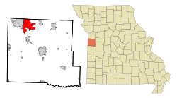
Location in the state of Missouri
|
|
| Country | United States |
| State | Missouri |
| County | Cass |
| Founded | 1874 |
| Incorporated | 1877 |
| Area | |
| • Total | 17.65 sq mi (45.72 km2) |
| • Land | 17.31 sq mi (44.84 km2) |
| • Water | 0.34 sq mi (0.88 km2) |
| Elevation | 1,109 ft (338 m) |
| Population
(2020)
|
|
| • Total | 22,941 |
| • Density | 1,325.15/sq mi (511.64/km2) |
| Time zone | UTC-6 (CST) |
| • Summer (DST) | UTC-5 (CDT) |
| ZIP code |
64083
|
| Area code(s) | 816 |
| FIPS code | 29-60752 |
| GNIS feature ID | 2396328 |
| Website | http://www.raymore.com |
Raymore is a city located in Cass County, Missouri, in the United States. It is part of the larger Kansas City Metropolitan Area.
Raymore has been growing quickly. From July 2022 to July 2023, it was the fastest-growing city in Missouri. It was also the 66th fastest-growing city in the entire country. Its population grew by 4.7% in just one year. As of July 2024, about 25,306 people live in Raymore. The official count from the 2020 census was 22,941 people.
Contents
Raymore's History
Raymore was first planned out in 1872. It officially became a city on March 20, 1877. The city's name comes from two railroad workers, George Rea and Henry Moore. Their last names were combined to create "Raymore." The city has had a post office since 1872.
A special place called the Watkins Family Farm Historic District was added to the National Register of Historic Places in 2007. This list helps protect important historical sites in the United States.
Raymore's Location and Land
Raymore is located in Missouri. The United States Census Bureau measures the city's total area. It covers about 17.75 square miles (45.97 square kilometers). Most of this area, about 17.58 square miles (45.53 square kilometers), is land. The rest, about 0.17 square miles (0.44 square kilometers), is water.
Raymore's Population
The city's population has changed a lot over the years. Here's how many people have lived in Raymore during different census years:
| Historical population | |||
|---|---|---|---|
| Census | Pop. | %± | |
| 1880 | 83 | — | |
| 1900 | 271 | — | |
| 1910 | 218 | −19.6% | |
| 1920 | 182 | −16.5% | |
| 1930 | 222 | 22.0% | |
| 1940 | 207 | −6.8% | |
| 1950 | 208 | 0.5% | |
| 1960 | 268 | 28.8% | |
| 1970 | 587 | 119.0% | |
| 1980 | 3,154 | 437.3% | |
| 1990 | 5,592 | 77.3% | |
| 2000 | 11,146 | 99.3% | |
| 2010 | 19,206 | 72.3% | |
| 2020 | 22,941 | 19.4% | |
| U.S. Decennial Census | |||
What the 2020 Census Showed
The 2020 United States census counted 22,941 people living in Raymore. There were 8,399 households and 6,202 families. A household is a group of people living together in one home.
The census also looked at the different backgrounds of people in Raymore. Most residents were white. There were also many people who identified as black or African-American, Native American, Asian, or from two or more races. Some residents were of Hispanic or Latino background.
About 24.3% of the people in Raymore were under 18 years old. The average age in the city was about 40.5 years.
What People Do in Raymore
Many people in Raymore work for different businesses and organizations. Here are some of the largest employers in the city as of July 2024:
| # | Employer | # of Employees |
|---|---|---|
| 1 | Walmart | 405 |
| 2 | Ray-Pec School District | 336 |
| 3 | Nuuly | 300 |
| 4 | Foxwood Springs | 274 |
| 5 | Compass Health Network | 215 |
| 6 | Cosentino's Price Chopper | 152 |
| 7 | Southern Glazer's Wine & Spirits | 150 |
| 8 | Sam's Club | 150 |
| 9 | Lowe's | 136 |
| 10 | City of Raymore | 108 |
Learning in Raymore
Public schools in Raymore are managed by the Raymore-Peculiar R-II School District. This district helps provide education for students living in the city.
See also
 In Spanish: Raymore (Misuri) para niños
 | Precious Adams |
 | Lauren Anderson |
 | Janet Collins |

