Red Bank, South Carolina facts for kids
Quick facts for kids
Red Bank, South Carolina
|
|
|---|---|

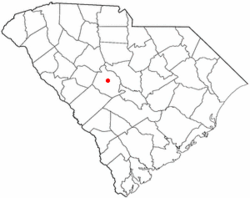
Location of Red Bank, South Carolina
|
|
| Country | United States |
| State | South Carolina |
| County | Lexington |
| Government | |
| • Type | None |
| Area | |
| • Total | 12.76 sq mi (33.05 km2) |
| • Land | 12.54 sq mi (32.47 km2) |
| • Water | 0.22 sq mi (0.58 km2) |
| Elevation | 341 ft (104 m) |
| Population
(2020)
|
|
| • Total | 10,924 |
| • Density | 871.34/sq mi (336.44/km2) |
| Time zone | UTC-5 (Eastern (EST)) |
| • Summer (DST) | UTC-4 (EDT) |
| ZIP code |
29073
|
| Area code(s) | 803, 839 |
| FIPS code | 45-59110 |
| GNIS feature ID | 1250298 |
Red Bank is a community in Lexington County, South Carolina, United States. It's known as a census-designated place (CDP). This means it's an area that the government counts as a community for statistics, even though it doesn't have its own local government.
In 2020, about 10,924 people lived in Red Bank. It's also part of the larger Columbia Metropolitan Area.
Contents
Geography of Red Bank
Red Bank is located in the eastern part of Lexington County. It sits at coordinates 33°55′55″N 81°13′49″W / 33.93194°N 81.23028°W.
Nearby Towns and Roads
To the north, Red Bank shares a border with Lexington, which is the main town of the county. To the south, it borders the White Knoll community.
South Carolina Highway 6 is the main road that goes through Red Bank. This highway leads north about 3.5 miles (5.6 km) to the center of Lexington. If you go south on Highway 6, it's about 5.5 miles (8.9 km) to Edmund.
Platt Springs Road, which is also South Carolina Highway 602 east of Highway 6, marks the border between Red Bank and White Knoll. Highway 602 goes northeast about 11 miles (18 km) to West Columbia.
Land and Water Features
The Red Bank area covers about 12.76 square miles (33.05 square kilometers). Most of this area is land, about 12.54 square miles (32.47 square kilometers). The rest, about 0.22 square miles (0.58 square kilometers), is water.
Red Bank Creek flows through the area. This creek eventually joins Congaree Creek, which is part of the larger Congaree River system. There are also two small lakes in the area: Crystal Lake and Saxe-Gotha Millpond. These lakes hold water from the creek.
Population and People
The population of Red Bank has grown over the years.
| Historical population | |||
|---|---|---|---|
| Census | Pop. | %± | |
| 2020 | 10,924 | — | |
| U.S. Decennial Census | |||
Who Lives in Red Bank?
The 2020 United States census counted 10,924 people living in Red Bank. There were 4,137 households and 3,035 families in the community.
The table below shows the different groups of people living in Red Bank based on the 2020 census:
| Race | Number of People | Percentage |
|---|---|---|
| White (not Hispanic) | 7,956 | 72.83% |
| Black or African American (not Hispanic) | 1,512 | 13.84% |
| Native American | 44 | 0.4% |
| Asian | 72 | 0.66% |
| Pacific Islander | 4 | 0.04% |
| Other/Mixed | 646 | 5.91% |
| Hispanic or Latino | 690 | 6.32% |
See also

- In Spanish: Red Bank para niños
 | May Edward Chinn |
 | Rebecca Cole |
 | Alexa Canady |
 | Dorothy Lavinia Brown |

