
Lexington, South Carolina facts for kids
Quick facts for kids
Lexington, South Carolina
|
||
|---|---|---|
 |
||
|
||
| Motto(s):
"Town of Progress"
|
||

Lexington, South Carolina
Location in South Carolina

Lexington, South Carolina
Location in the United States
|
||
| Country | ||
| State | ||
| County | Lexington County | |
| Named for | Battles of Lexington and Concord | |
| Government | ||
| • Type | Mayor-Council | |
| • Body | Lexington Town Council | |
| Area | ||
| • Total | 12.12 sq mi (31.38 km2) | |
| • Land | 11.97 sq mi (31.00 km2) | |
| • Water | 0.14 sq mi (0.38 km2) | |
| Elevation | 394 ft (120 m) | |
| Population
(2020)
|
||
| • Total | 23,568 | |
| • Rank | 22nd | |
| • Density | 1,968.92/sq mi (760.19/km2) | |
| Time zone | UTC−5 (Eastern (EST)) | |
| • Summer (DST) | UTC−4 (EDT) | |
| ZIP codes |
29071, 29072, 29073
|
|
| Area code(s) | 803, 839 | |
| FIPS code | 45-41335 | |
| GNIS feature ID | 1246349 | |

Lexington is a busy town in South Carolina, USA. It is the biggest town in Lexington County. It is also the county seat, which means it is where the main government offices are.
Lexington is a suburb of Columbia, the state capital. In 2020, about 23,568 people lived here. It is one of the fastest-growing areas in the middle of South Carolina.
Contents
History of Lexington
Early Days and Settlements


In 1735, King George II's government created 11 new areas in South Carolina. These areas were meant to encourage people to settle there. They also acted as a buffer between Native American tribes and the colonial farms.
One of these areas was called Saxe Gotha. People from Germany and Switzerland settled there. They grew crops like corn, wheat, and tobacco. They also raised livestock. Two important Native American trails crossed through this area. The Cherokee Path was used by English traders. The Occaneechi Path connected tribes from different regions.
In 1785, Saxe Gotha was renamed Lexington County. This was to remember the Battles of Lexington and Concord in Massachusetts. These battles were important in the American Revolution. Two battles were fought near Lexington in 1781. The Battle of Muddy Springs was just south of town. The Battle of Tarrar Springs was right within the town's current borders.
Growth and Challenges
Before 1820, the county seat was in a town called Granby. But Granby often flooded. So, the courthouse moved to its current spot in Lexington. The area was known as "Lexington Courthouse." It officially became the Town of Lexington in 1861.
During the American Civil War, much of Lexington was destroyed. This happened during Sherman's March to the Sea. Union forces burned most of the town, including the courthouse. After the war, Lexington faced tough economic times. But local farms and the lumber industry helped the town recover.
Many brick buildings you see today were built after big fires in 1894 and 1916. By the 1890s, a railroad and a textile mill helped Lexington grow. In the 1920s, cars became popular. This helped Lexington grow even more as a suburb of Columbia. Also, Lake Murray was created in 1930. This brought more people to live in Lexington. The town's population grew a lot between 1990 and 2010.
Recent Important Events


Lexington is where the "move over law" started. This law says drivers must change lanes. They must do this when an emergency vehicle is stopped on the side of the road. A paramedic named James D. Garcia was hurt in 1994. He was helping at an accident scene. This led him to work for this law. South Carolina passed the law in 1996. Now, a similar law is in all 50 U.S. states.
In 1994, a strong tornado hit Lexington. It caused over 40 injuries and $50 million in damages. This tornado came from a tropical storm.
In 2013, a gas station in Lexington sold a winning Powerball ticket. It was worth $400 million! This was one of the biggest lottery wins in U.S. history at the time.
In 2015, heavy rains from Hurricane Joaquin caused huge floods. In Lexington, two dams were destroyed. Gibson Park Dam and Old Mill Dam both broke. These dams have since been rebuilt. The floods also damaged many roads and businesses.
Geography of Lexington
Lexington is in the northeastern part of Lexington County. It is about 12 miles west of Columbia. Columbia is the state capital of South Carolina.
The town covers about 11.97 square miles of land. It has a small amount of water, about 0.14 square miles. Two creeks flow through the town. Fourteenmile Creek is to the north. Twelvemile Creek is to the south. Both creeks flow into the Saluda River.
Climate in Lexington
Lexington has a varied climate. The coldest temperature ever recorded was -2°F in February 1899. The hottest was 111°F in June 2012.
July usually has the most rain each year. Lexington gets about 48 inches of rain per year. It does not get much snow, averaging about 1.6 inches per year.
| Climate data for Columbia, South Carolina (Columbia Airport), 1981–2010 normals | |||||||||||||
|---|---|---|---|---|---|---|---|---|---|---|---|---|---|
| Month | Jan | Feb | Mar | Apr | May | Jun | Jul | Aug | Sep | Oct | Nov | Dec | Year |
| Record high °F (°C) | 84 (29) |
84 (29) |
93 (34) |
96 (36) |
101 (38) |
107 (42) |
109 (43) |
107 (42) |
106 (41) |
101 (38) |
90 (32) |
83 (28) |
109 (43) |
| Mean daily maximum °F (°C) | 56.0 (13.3) |
61 (16) |
68 (20) |
76 (24) |
84 (29) |
90 (32) |
93 (34) |
91 (33) |
85 (29) |
76 (24) |
67 (19) |
58 (14) |
75 (24) |
| Mean daily minimum °F (°C) | 30 (−1) |
33 (1) |
41 (5) |
50 (10) |
60 (16) |
68 (20) |
72 (22) |
71 (22) |
64 (18) |
52 (11) |
42 (6) |
32 (0) |
51 (11) |
| Record low °F (°C) | −1 (−18) |
−4 (−20) |
4 (−16) |
26 (−3) |
34 (1) |
44 (7) |
54 (12) |
53 (12) |
40 (4) |
23 (−5) |
12 (−11) |
4 (−16) |
−4 (−20) |
| Average precipitation inches (mm) | 3.58 (91) |
3.74 (95) |
3.73 (95) |
2.62 (67) |
2.97 (75) |
4.69 (119) |
5.46 (139) |
5.26 (134) |
3.54 (90) |
3.17 (81) |
2.74 (70) |
3.22 (82) |
44.56 (1,132) |
| Average snowfall inches (cm) | 0.1 (0.25) |
0.8 (2.0) |
0.1 (0.25) |
0 (0) |
0 (0) |
0 (0) |
0 (0) |
0 (0) |
0 (0) |
0 (0) |
0 (0) |
0.1 (0.25) |
1.6 (4.1) |
| Average precipitation days (≥ 0.01 in) | 9.9 | 9.1 | 8.6 | 8.0 | 7.7 | 10.5 | 11.8 | 10.5 | 7.3 | 7.0 | 7.3 | 9.0 | 106.8 |
| Average snowy days (≥ 0.1 in) | 0.5 | 0.3 | 0.1 | 0 | 0 | 0 | 0 | 0 | 0 | 0 | 0 | 0.1 | 1.0 |
| Mean monthly sunshine hours | 173.6 | 183.6 | 238.7 | 270.0 | 291.4 | 279.0 | 285.2 | 263.5 | 240.0 | 235.6 | 195.0 | 173.6 | 2,829.2 |
| Source: NOAA (extremes 1887–present), | |||||||||||||
Lexington's Economy

In 2022, stores in Lexington sold almost $2.5 billion worth of goods. In 2020, the average household income was about $74,996. About 9.11% of people lived below the poverty line.
Here are some of the biggest employers in Lexington:
| # | Employer | # of Employees |
|---|---|---|
| 1 | Lexington School District 1 | 1,083 |
| 2 | Lexington County | 905 |
| 3 | Walmart | 367 |
| 4 | Town of Lexington | 180 |
| 5 | Publix | 160 |
| 6 | Lowe's | 150 |
| 7 | Home Depot | 150 |
| 8 | Avtec | 135 |
| 9 | Target | 120 |
| 10 | Kohl's | 107 |
Transportation in Lexington
Public Transit
The COMET provides public transportation in Lexington. It is the main bus system for the greater Columbia area.
Roads and Highways
Lexington is connected by several important roads:
 I-20 – This interstate highway goes from west to east. It connects Columbia to cities like Atlanta and Augusta. It also serves nearby towns like West Columbia.
 U.S. 1
 U.S. 378
 SC 6
SC 6
Fun Things to Do in Lexington

- Lake Murray: Just north of Lexington is Lake Murray. It is one of South Carolina's biggest lakes. A 1.7-mile-long dam holds the lake. You can drive, bike, run, or walk on the dam. The Saluda Dam helps make electricity for the area. There is a public swimming area open in summer.
- Lexington County Blowfish Baseball Stadium: You can watch baseball games here.
- Icehouse Amphitheater: This outdoor venue hosts concerts and events. Many famous musicians have played here.
- Parks: Lexington has several public parks. These include Virginia Hilton Park, Gibson Pond Park, and Corley Street Water Park.
- Lexington County Museum: Learn about the history of the area at this museum.
- Fourteen-Mile Creek Trail: A great place for walking and enjoying nature.

People of Lexington
Population Changes
| Historical population | |||
|---|---|---|---|
| Census | Pop. | %± | |
| 1880 | 262 | — | |
| 1890 | 342 | 30.5% | |
| 1900 | 806 | 135.7% | |
| 1910 | 709 | −12.0% | |
| 1920 | 894 | 26.1% | |
| 1930 | 1,152 | 28.9% | |
| 1940 | 1,033 | −10.3% | |
| 1950 | 1,081 | 4.6% | |
| 1960 | 1,127 | 4.3% | |
| 1970 | 969 | −14.0% | |
| 1980 | 2,131 | 119.9% | |
| 1990 | 3,289 | 54.3% | |
| 2000 | 9,793 | 197.8% | |
| 2010 | 17,870 | 82.5% | |
| 2020 | 23,568 | 31.9% | |
| U.S. Decennial Census | |||
Lexington has grown a lot! In 2000, there were about 10,000 people. By 2020, the population was 23,568. This is a big increase. Many new homes and businesses have been built.
Who Lives Here?
In 2020, there were 23,568 people living in Lexington. Most people (about 71%) were White. About 11% were Black or African American. About 7% were Asian. Other groups, including people of mixed races and Hispanic or Latino people, made up the rest.
The average age in Lexington in 2010 was 33 years old. About 27% of the people were under 18. About 7.5% were 65 or older.
Education in Lexington
Lexington County School District One manages public education in Lexington. The district has over 27,000 students. It also employs about 3,900 teachers and staff.
Here are some of the public schools in the area:
| Elementary schools | Enrollment |
|---|---|
| Pleasant Hill Elementary School | 948 |
| Midway Elementary School | 947 |
| Meadow Glen Elementary School | 908 |
| Carolina Springs Elementary School | 800 |
| Lake Murray Elementary School | 759 |
| Saxe Gotha Elementary School | 752 |
| Rocky Creek Elementary | 730 |
| Deerfield Elementary School | 723 |
| Oak Grove Elementary School | 715 |
| White Knoll Elementary | 711 |
| New Providence Elementary School | 672 |
| Lexington Elementary School | 644 |
| Red Bank Elementary School | 579 |
| Middle schools | Enrollment |
| Pleasant Hill Middle School | 1,208 |
| Meadow Glen Middle School | 1,029 |
| Lakeside Middle School | 992 |
| Carolina Springs Middle | 930 |
| Beechwood Middle School | 850 |
| White Knoll Middle School | 787 |
| High schools | Enrollment |
| Lexington High School | 2,105 |
| River Bluff High School | 2,047 |
| White Knoll High School | 1,955 |
| Lexington Technology Center | |
| Adult education | Enrollment |
| Rosenwald Community Learning Center | 100 |
Library
Lexington has a branch of the Lexington County Public Library. It is a great place to find books and learn.
Famous People from Lexington
- John Boozer: A former professional baseball player. He played for the Philadelphia Phillies.
- Nick Ciuffo: A baseball player drafted in the first round by the Tampa Bay Rays.
- Emily Geiger: An American Revolutionary War heroine. She bravely delivered a secret message.
- Nikki Haley: A former United States Ambassador to the United Nations. She was also the governor of South Carolina.
- Lacie Lybrand: She was crowned Miss South Carolina USA in 2006.
- Bob Peeler: A former Lieutenant Governor of South Carolina.
- Shaq Roland: A former wide receiver for college football teams and the Chicago Bears practice squad.
- Floyd Spence: A congressman who represented the area for many years.
- Harold E. Wilson: A Marine who received the Congressional Medal of Honor for his bravery in the Korean War.
- Caitlin Upton: A model and beauty pageant winner.
Images for kids
-
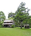
The Ballentine-Shealy House built around 1870.

See also
 In Spanish: Lexington (Carolina del Sur) para niños
