
Redding Township, Michigan facts for kids
Quick facts for kids
Redding Township, Michigan
|
|
|---|---|

Redding Township Hall
|
|

Location within Clare County
|
|

Redding Township, Michigan
Location in Michigan

Redding Township, Michigan
Location in the United States
|
|
| Country | United States |
| State | Michigan |
| County | Clare |
| Established | 1891 |
| Area | |
| • Total | 35.43 sq mi (91.76 km2) |
| • Land | 34.90 sq mi (90.39 km2) |
| • Water | 0.53 sq mi (1.37 km2) |
| Elevation | 1,053 ft (321 m) |
| Population
(2020)
|
|
| • Total | 459 |
| • Density | 13.2/sq mi (5.1/km2) |
| Time zone | UTC-5 (Eastern (EST)) |
| • Summer (DST) | UTC-4 (EDT) |
| ZIP code(s) | |
| Area code(s) | 989 |
| FIPS code | 26-67600 |
| GNIS feature ID | 1626959 |

Redding Township is a small area in Clare County, Michigan, in the United States. It's like a local government area. In 2020, about 459 people lived there.
Contents
Places in Redding Township
Redding Township has a few interesting places.
Clarence
Clarence used to be a small settlement. It grew around a lumber mill in 1888. A post office opened there in 1893, but it's not there anymore.
Temple
Temple is a small community in the middle of the township. It's located along M-61. It started as a train station in 1889. The land was given by Mary Campbell, and it was first called Campbell City. A post office opened in 1890 and was named Temple after a local person, Martin Temple. The post office closed in 1966.
Geography of Redding Township
Redding Township covers about 35.43 square miles (91.76 square kilometers). Most of this area is land. About 0.53 square miles (1.37 square kilometers) is water.
Muskegon River
The Muskegon River flows through the center of the township. It moves towards the southwest.
Main Roads
- M-61 (also called Temple Drive) goes east to west through the township.
- M-115 is a road that runs just outside the southwest part of the township.
History of Redding Township
Redding Township was officially started in 1891. This means it became a recognized local government area in that year.
How Redding Township is Governed
A civil township is a type of local government. It helps manage services for the people living there.
Leaders
- The main leader is called the Supervisor. Their name is Bruce Scarbrough.
- The Clerk helps with official records and paperwork. The Clerk is Susie Brower.
Education
All the children in Redding Township go to schools run by Marion Public Schools. These schools are located in the village of Marion. Marion is in Osceola County, which is northwest of Redding Township.
Images for kids
-
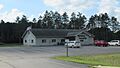
Redding Township Hall
-
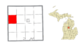
Location within Clare County
See also
 In Spanish: Municipio de Redding (Míchigan) para niños
