
Reeds Ferry, New Hampshire facts for kids
Quick facts for kids
Reeds Ferry, New Hampshire
|
|
|---|---|

Village market at the junction of Rte. 3 and Bedford Road
|
|

Reeds Ferry, New Hampshire
Location in New Hampshire

Reeds Ferry, New Hampshire
Location in the United States
|
|
| Country | United States |
| State | New Hampshire |
| County | Hillsborough |
| Town | Merrimack |
| Elevation | 188 ft (57 m) |
| Time zone | UTC-5 (Eastern (EST)) |
| • Summer (DST) | UTC-4 (EDT) |
| Area code(s) | 603 |
| GNIS feature ID | 869479 |
Reeds Ferry is a community located in the northern part of the town of Merrimack, New Hampshire. It is named after an old ferry service run by William Reed. This ferry used to cross the Merrimack River. Today, Reeds Ferry is centered around the intersection of Bedford Road and Daniel Webster Highway (U.S. Route 3).
Contents
What is Reeds Ferry?
Reeds Ferry is a small community within the larger town of Merrimack, New Hampshire. It's known for its historical connection to a ferry crossing. This ferry was a way for people to cross the Merrimack River long ago. The main area of Reeds Ferry is now where two important roads meet: Bedford Road and Daniel Webster Highway.
Where is Reeds Ferry Located?
The exact boundaries of Reeds Ferry can be a bit unclear. Traditionally, it was defined by its location along the Merrimack River. However, some parts of Merrimack, like the area near Baboosic Lake, are not usually considered part of Reeds Ferry. This is because the Baboosic Lake area is separated by a major road called the Everett Turnpike. Also, the main part of Reeds Ferry is now separated from the river by a railway.
Important Places in Reeds Ferry
Even though it's a small community, Reeds Ferry has a few important spots:
- Reeds Ferry Elementary School: This school is located on Lyons Road.
- Reeds Ferry Cemetery: You can find the cemetery where Bedford Road and Route 3 meet.
- The Old Ferry Landing: The site where William Reed's ferry used to land is now a parking lot. This parking lot is used as a boat ramp for people who want to put their boats into the Merrimack River.
The Old Train Station
The boat ramp parking lot is also the former site of the Reeds Ferry train station. This train station was an active stop for trains from 1842 until 1967. It played a role in connecting the community to other places by rail for many years.
Images for kids
-
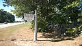
Reeds Ferry cemetery
-
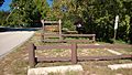
Parking for the boat ramp, former ferry landing site
-
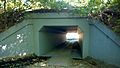
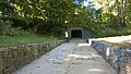
Viaduct at boat launch site leading to ferry landing site
-
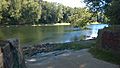
Looking across the Merrimack River to Litchfield from the boat launch
-
View from boat ramp to railway viaduct
-
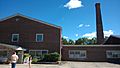
Former lumber mill in Reeds Ferry
-
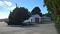
Former fire station across from the former lumber mill


