
Regions of Iceland facts for kids
The regions of Iceland are ways to divide the country into different areas. These areas are mostly used for collecting information and numbers. For example, they help organize the district courts, which are like local courts. The system for postal codes (like zip codes) also mostly follows these regions. Before 2003, these regions were even used for elections, which is how people choose their leaders for the parliament (the country's main law-making group).
It's important to know that these regions are not official government areas. They don't have their own special laws or leaders. Instead, they are just helpful ways to split up Iceland for different reasons.
Iceland's health care system also uses these regions. It has 7 health care areas. These are almost the same as the 8 regions, except for one part: the Northwestern and Northeastern regions are combined into one health care area.
What Are the Regions of Iceland?

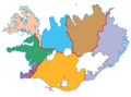
Iceland is divided into 8 main regions. Each region has its own population (how many people live there), a certain area size, and a main city or town. Here's a look at each one:
| Number | Name of Region | Number of People | Area (square kilometers) | Main City or Town |
|---|---|---|---|---|
| 1 | Capital Region | 205,675 | 1,062 | Reykjavík |
| 2 | Southern Peninsula | 21,206 | 829 | Keflavík |
| 3 | Western Region | 15,381 | 9,554 | Akranes |
| 4 | Westfjords | 7,031 | 9,409 | Ísafjörður |
| 5 | Northwestern Region | 7,271 | 12,737 | Sauðárkrókur |
| 6 | Northeastern Region | 29,026 | 21,968 | Akureyri |
| 7 | Eastern Region | 12,434 | 22,721 | Egilsstaðir |
| 8 | Southern Region | 23,833 | 24,526 | Selfoss |
Images for kids
-
This map shows the election areas used in Iceland between 1959 and 2003.

See also
 In Spanish: Regiones de Islandia para niños
