Relief map of Guatemala facts for kids
Quick facts for kids Relief map of Guatemala |
|
|---|---|
|
Mapa en Relieve de Guatemala
|
|

The map in 2021
|
|
| Alternative names | Mapa en Relieve |
| General information | |
| Location | Guatemala City, |
| Construction started | 19 April 1904 |
| Completed | 29 October 1905 |
| Owner | Municipality of Guatemala City |
| Technical details | |
| Structural system | brick, mortar and cement lining |
| Design and construction | |
| Architect | Domingo Penedo |
| Structural engineer | Francisco Vela |
| Civil engineer | Claudio Urrutia |
| Main contractor | A. Doninelli & Cia. (perimeter railing) |
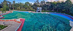
The Relief Map of Guatemala (or Mapa en Relieve de Guatemala in Spanish) is a giant map of Guatemala. It's a special kind of map that shows mountains, valleys, and rivers in 3D, just like they are in real life! This huge map is built on the ground and covers about 1,800 square meters. It's located in Guatemala City.
Contents
Building the Giant Map
This amazing map was built very quickly. It took only 18 months to finish! Construction started on April 19, 1904, and ended on October 29, 1905.
Who Built It?
The map was designed by a Guatemalan engineer named Francisco Vela. He worked with another engineer, Claudio Urrutia. They used lots of information about Guatemala's land to make the map super accurate. The map is made from brick, mortar, and a special cement coating.
How the Map Works
The map shows all of Guatemala's land features.
- The base of the map is made of stone.
- Areas for the Atlantic and Pacific Oceans use pumice stone.
- The outlines of the land are made from brick.
- Tiny lead lines show where railroads are.
- Small steel bridges cross the rivers.
One of the coolest parts is how the water works! An underground tank holds 60 cubic meters of water. This water flows through a special system to fill the lakes and rivers on the map. It uses a scientific idea called "communicating vessels." This means the water levels are always correct, just like in real life. The main water control box is hidden in the "Los Cuchumatanes" mountain range area of the map.
Map's Surroundings
Around the map, there's a low wall or handrail. It's about 90 centimeters tall. This wall has six cool decorations called medallions. These medallions show pictures and symbols from Guatemala's history.
Map Updates
The Relief Map has been fixed up and improved two times.
- The first time was in 1980.
- The second time was in 2014.
These updates help keep the map looking great for everyone to enjoy.
Exhibition Hall
Next to the Relief Map, there's an exhibition hall. This room has a photo display called "Guatemala Siglo XVIII." That means "Guatemala in the 18th century."
What You'll See
The photos and information in the hall tell a story. They show important events that led to the city of Guatemala moving to its current location in 1776. It's a great way to learn about the city's past.
Sound Forest of Hormigo
On the east side of the Relief Map area, you'll find a special place called the Sound Forest of Hormigo. This forest is unique because it honors famous music composers and marimba players from around the world.
Why Hormigo Trees?
The forest is named after the "hormigo" tree. This tree is very important in Guatemala. Its wood is used to build the marimba, which is Guatemala's national musical instrument. The hormigo tree is also known as the "Tree of Culture, Marimba, and Peace."
Honoring Musicians
The idea for the forest started in 1983 and 1984. Inside the forest, there are over 100 hormigo trees. Each tree was planted to honor a well-known Guatemalan composer or marimba player. A small plaque next to each tree shows the name of the person it honors.
See also
 In Spanish: Mapa en Relieve de Guatemala para niños
- Great Polish Map of Scotland
- World Map at Lake Klejtrup
 | Sharif Bey |
 | Hale Woodruff |
 | Richmond Barthé |
 | Purvis Young |

