
René-Levasseur Island facts for kids
|
Native name:
Île René-Levasseur
|
|
|---|---|

René-Levasseur Island is the large island in the centre of this image. Image courtesy of NASA.
|
|

René-Levasseur
Location in Quebec

René-Levasseur
Location in Côte-Nord region, Quebec
|
|
| Geography | |
| Location | Manicouagan Reservoir, Rivière-aux-Outardes / Rivière-Mouchalagane, Quebec |
| Coordinates | 51°23′50″N 68°41′30″W / 51.39722°N 68.69167°W |
| Area | 2,020 km2 (780 sq mi) |
| Highest elevation | 952 m (3,123 ft) |
| Highest point | Mount Babel |
| Administration | |
|
Canada
|
|
| Province | Quebec |
| Region | Côte-Nord |
| Regional county municipality | Manicouagan |
René-Levasseur Island is a very large island located in the middle of Lake Manicouagan in Quebec, Canada. It is sometimes called the "eye of Quebec" because of its unique shape.
The island's highest point is Mount Babel, which reaches 952 meters (3,123 feet) high. This mountain is part of the Louis-Babel Ecological Reserve. René-Levasseur Island covers an area of 2,020 square kilometers (780 square miles). This makes it larger than the ring-shaped lake that surrounds it. It is the second largest island found in a lake anywhere in the world. Only Manitoulin Island in Lake Huron is bigger.
Contents
How René-Levasseur Island Was Formed
The Meteorite Impact
About 214 million years ago, a huge meteorite crashed into Earth. Scientists believe this meteorite was about 5 kilometers (3 miles) wide. It hit the Earth at an incredible speed of 17 kilometers per second (10.5 miles per second). This impact was one of the most powerful known in Earth's history.
The crash created a giant hole, or crater, about 100 kilometers (62 miles) wide. The center of this huge crater is where René-Levasseur Island is located today.
Becoming an Island in a Lake
Originally, the area had two crescent-shaped lakes: Mouchalagane Lake and Manicouagan Lake. In 1970, a large dam was built on the Manicouagan River. This dam created the Manicouagan Reservoir, which flooded the area.
When the reservoir filled up, the land in the center of the crater became completely surrounded by water. This turned it into an artificial island. René-Levasseur Island is now the largest artificial island in the world. The dam that created the reservoir is called the Daniel-Johnson Dam. It is the world's largest multiple-arch dam.
Protecting René-Levasseur Island
Efforts to Protect the Land
René-Levasseur Island is a special place. It has many very old forests that have not been cut down. Because of this, many groups want to protect the entire island.
An environmental group called SOS Levasseur started in 2003. They want the Quebec government to make the whole island a protected area. They have suggested it become a Canadian National Park, an ecological reserve, or a special geological site.
Legal Battles and Research
The Innu First Nation people of Pessamit are also working to protect their traditional land on the island. They have taken legal action to stop logging activities there. Logging is when trees are cut down for wood.
SOS Levasseur has been doing research on the island since 2005. They look for old-growth forests to help protect them under Quebec's Forest Law. These special forests are called "Exceptional Forest Ecosystems" (EFEs). So far, some EFEs have been identified by the government and a logging company. SOS Levasseur has found even more and is working to get them protected.
Images for kids
-
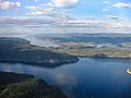
René-Levasseur Island in the background
-
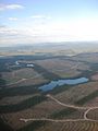
Clearcutting on the island
-
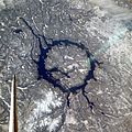
As seen from space shuttle (north is to the lower right)

.JPG)

See also
 In Spanish: René-Levasseur para niños
