
Republican City, Nebraska facts for kids
Quick facts for kids
Republican City, Nebraska
|
|
|---|---|
|
Village
|
|

Republican City, seen from U.S. Route 136
|
|

Location of Republican City, Nebraska
|
|

Republican City, Nebraska
Location in Nebraska

Republican City, Nebraska
Location in the United States
|
|
| Country | United States |
| State | Nebraska |
| County | Harlan |
| Township | Mullally |
| Area | |
| • Total | 0.33 sq mi (0.84 km2) |
| • Land | 0.33 sq mi (0.84 km2) |
| • Water | 0.00 sq mi (0.00 km2) |
| Elevation | 2,024 ft (617 m) |
| Population
(2020)
|
|
| • Total | 134 |
| • Density | 412.31/sq mi (158.97/km2) |
| Time zone | UTC-6 (Central (CST)) |
| • Summer (DST) | UTC-5 (CDT) |
| ZIP code |
68971
|
| Area code(s) | 308 |
| FIPS code | 31-41130 |
| GNIS feature ID | 2399060 |
Republican City is a small village located in Harlan County, Nebraska, in the United States. In 2020, about 134 people lived there. The village is very close to the Harlan County Reservoir, a large lake. Back in the 1950s, Republican City was much bigger, with about four times more people than it has today.
Contents
History of Republican City
Republican City was started a long time ago, in 1871. It got its name from the Republican River, which flows nearby.
Geography and Location
Republican City is a small place, covering about 0.84 square kilometers (or 0.33 square miles) of land. There is no water area within the village limits.
Climate and Weather
The weather in Republican City changes a lot throughout the year. Summers are usually hot, and winters can be very cold.
| Climate data for Republican City, Nebraska (Harlan County Lake) 1991–2020 normals, extremes 1894–present | |||||||||||||
|---|---|---|---|---|---|---|---|---|---|---|---|---|---|
| Month | Jan | Feb | Mar | Apr | May | Jun | Jul | Aug | Sep | Oct | Nov | Dec | Year |
| Record high °F (°C) | 77 (25) |
80 (27) |
89 (32) |
97 (36) |
100 (38) |
108 (42) |
111 (44) |
108 (42) |
105 (41) |
96 (36) |
86 (30) |
81 (27) |
111 (44) |
| Mean daily maximum °F (°C) | 39.0 (3.9) |
44.2 (6.8) |
55.5 (13.1) |
64.6 (18.1) |
73.7 (23.2) |
84.7 (29.3) |
90.0 (32.2) |
87.6 (30.9) |
80.7 (27.1) |
67.8 (19.9) |
53.5 (11.9) |
41.7 (5.4) |
65.2 (18.4) |
| Daily mean °F (°C) | 26.6 (−3.0) |
31.0 (−0.6) |
41.4 (5.2) |
51.0 (10.6) |
61.3 (16.3) |
72.4 (22.4) |
77.7 (25.4) |
75.3 (24.1) |
67.0 (19.4) |
53.5 (11.9) |
40.1 (4.5) |
30.0 (−1.1) |
52.3 (11.3) |
| Mean daily minimum °F (°C) | 14.3 (−9.8) |
17.8 (−7.9) |
27.3 (−2.6) |
37.3 (2.9) |
48.9 (9.4) |
60.0 (15.6) |
65.4 (18.6) |
63.0 (17.2) |
53.3 (11.8) |
39.2 (4.0) |
26.6 (−3.0) |
18.2 (−7.7) |
39.3 (4.1) |
| Record low °F (°C) | −24 (−31) |
−28 (−33) |
−18 (−28) |
9 (−13) |
18 (−8) |
34 (1) |
40 (4) |
42 (6) |
21 (−6) |
3 (−16) |
−10 (−23) |
−35 (−37) |
−35 (−37) |
| Average precipitation inches (mm) | 0.38 (9.7) |
0.50 (13) |
1.26 (32) |
2.43 (62) |
4.06 (103) |
3.57 (91) |
4.05 (103) |
3.19 (81) |
1.64 (42) |
1.95 (50) |
0.83 (21) |
0.81 (21) |
24.67 (627) |
| Average snowfall inches (cm) | 3.5 (8.9) |
4.2 (11) |
1.8 (4.6) |
0.6 (1.5) |
0.0 (0.0) |
0.0 (0.0) |
0.0 (0.0) |
0.0 (0.0) |
0.0 (0.0) |
1.3 (3.3) |
1.6 (4.1) |
2.3 (5.8) |
15.3 (39) |
| Average precipitation days (≥ 0.01 in) | 3.0 | 3.2 | 4.1 | 8.3 | 10.4 | 8.9 | 8.8 | 8.7 | 6.0 | 5.3 | 3.1 | 2.4 | 72.2 |
| Average snowy days (≥ 0.1 in) | 1.9 | 2.4 | 0.9 | 0.3 | 0.0 | 0.0 | 0.0 | 0.0 | 0.0 | 0.2 | 1.0 | 1.2 | 7.9 |
| Source: NOAA | |||||||||||||
Population Changes Over Time
The number of people living in Republican City has changed a lot over the years. Here's how the population has grown and shrunk:
| Historical population | |||
|---|---|---|---|
| Census | Pop. | %± | |
| 1880 | 282 | — | |
| 1890 | 428 | 51.8% | |
| 1900 | 386 | −9.8% | |
| 1910 | 476 | 23.3% | |
| 1920 | 424 | −10.9% | |
| 1930 | 417 | −1.7% | |
| 1940 | 331 | −20.6% | |
| 1950 | 580 | 75.2% | |
| 1960 | 189 | −67.4% | |
| 1970 | 179 | −5.3% | |
| 1980 | 231 | 29.1% | |
| 1990 | 199 | −13.9% | |
| 2000 | 209 | 5.0% | |
| 2010 | 150 | −28.2% | |
| 2020 | 134 | −10.7% | |
| U.S. Decennial Census | |||
Who Lives in Republican City?
Based on the 2010 census, there were 150 people living in Republican City. These people lived in 76 different homes, and 47 of those were families.
Almost everyone living in the village (100%) was White. A small number, about 1.3%, were of Hispanic or Latino background.
Many homes (56.6%) were married couples living together. About 13.2% of homes had children under 18. A good number of homes (34.2%) had just one person living there, and many of those (15.8%) were people aged 65 or older.
The average age of people in the village was about 59.8 years old. This means it's a community with many older adults.
- 14% of residents were under 18.
- 3.4% were between 18 and 24.
- 11.3% were between 25 and 44.
- 32.7% were between 45 and 64.
- 38.7% were 65 or older.
Slightly more than half the population (52.7%) was male, and 47.3% was female.
Images for kids
-
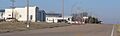
Republican City, seen from U.S. Route 136
-
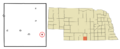
Location of Republican City, Nebraska
See also
 In Spanish: Republican City (Nebraska) para niños
