
Rheingau-Taunus-Kreis facts for kids
Quick facts for kids
Rheingau-Taunus
|
|||
|---|---|---|---|
|
|||
| Country | |||
| State | Hesse | ||
| Adm. region | Darmstadt | ||
| Capital | Bad Schwalbach | ||
| Area | |||
| • Total | 811.11 km2 (313.17 sq mi) | ||
| Time zone | UTC+1 (CET) | ||
| • Summer (DST) | UTC+2 (CEST) | ||
| Vehicle registration | RÜD, SWA | ||


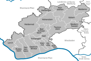
Rheingau-Taunus is a special area, like a county, in the western part of Hesse, a state in Germany. Its main office is in a town called Bad Schwalbach. Other important offices are in Idstein and Rüdesheim am Rhein. This district is part of the Darmstadt region.
The Rheingau-Taunus district shares its borders with other districts. These include Limburg-Weilburg, Hochtaunuskreis, Main-Taunus-Kreis, and the city of Wiesbaden in Hesse. It also borders Mainz-Bingen and Rhein-Lahn which are in another German state called Rhineland-Palatinate.
Contents
A Look Back: The History of Rheingau-Taunus
The area known as Rheingau has a long history. From the year 983 until 1803, it belonged to the Electorate of Mainz. This was a powerful church state in Germany. After 1803, the Rheingau became part of a new country called the Duchy of Nassau.
The Untertaunus region was once part of the Earldom of Katzenelnbogen. In 1816, the entire area of what is now the Rheingau-Taunus district became part of the Duchy of Nassau.
Later, in 1866, there was a war called the Austro-Prussian War. After this war, Nassau was taken over by Prussia. It then became part of a new Prussian province called Hesse-Nassau.
In 1867, the province was divided into smaller areas called districts. This is how the districts of Rheingau and Untertaunus were first created.
After the Second World War, the state of Hesse was formed in 1946. The two districts, Rheingau and Untertaunus, stayed separate for many years. But in 1977, the government decided to redraw some borders. This led to the two districts merging together. They then formed the single district we know today as Rheingau-Taunus.
Exploring the Geography of Rheingau-Taunus

The Rheingau-Taunus district is located in the western part of the Taunus mountains. These mountains are a beautiful natural feature of the area.
The famous river Rhine forms the southern border of the district. This river is very important for trade and tourism in Germany.
Understanding the Coat of Arms
The coat of arms for the Rheingau-Taunus district tells a story about its past. It combines symbols from the two older districts that merged to form it.
On the bottom right, you can see the Mainz wheel. This symbol comes from the old Rheingau district. It represents the time when the Rheingau area belonged to the Electorate of Mainz.
On the top left, there is a lion. This lion is the symbol of Nassau. It comes from the former Untertaunuskreis. This part of the coat of arms reminds us that the area was once part of the Duchy of Nassau.
Towns and Municipalities in the District
The Rheingau-Taunus district is made up of several towns and smaller communities called municipalities. These are the local areas where people live and work.
Towns
- Bad Schwalbach
- Eltville
- Geisenheim
- Idstein
- Lorch
- Oestrich-Winkel
- Rüdesheim
- Taunusstein
Municipalities
- Aarbergen
- Heidenrod
- Hohenstein
- Hünstetten
- Kiedrich
- Niedernhausen
- Schlangenbad
- Waldems
- Walluf
See also
 In Spanish: Distrito de Rheingau-Taunus para niños
