Ria of Ferrol facts for kids
Quick facts for kids Ria of Ferrol |
|
|---|---|
 |
|
| Coordinates | 43°28′24″N 8°13′07″W / 43.4734°N 8.21851°W |
| Type | Ria |
| River sources | Xuvia River |
| Ocean/sea sources | Atlantic Ocean |
| Basin countries | Spain |
| Settlements | Ferrol, Narón, Neda, Fene, Mugardos |
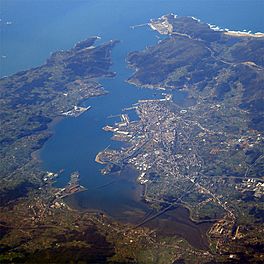
The Ria of Ferrol (also called the Bay of Ferrol) is a special type of bay in Galicia, Spain. It's like a river valley that the ocean has filled, making it a mix of fresh and salty water. The Xuvia River flows into it.
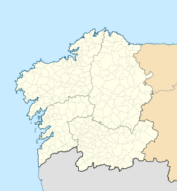
This ria is located in the A Coruña province, in the northwest part of Spain. Long ago, in Roman times, it was part of a big gulf called Portus Magnus Artabrorum.
The Ria of Ferrol has always been an important place for ships. It became a major base for the Spanish Navy a long time ago. To protect it, forts like San Felipe and La Palma were built. These forts watched over ships entering and leaving the bay.
Many towns are located around the ria, including Ferrol, Narón, Neda, Fene, and Mugardos. People have changed the ria quite a bit over time. Even so, it's still home to many sea creatures. People often collect seafood like different kinds of clams and cockles from its waters.
Contents
What is a Ria?
A ria is a coastal inlet, which means a part of the sea that reaches inland. It's formed when a river valley gets flooded by the ocean. This creates a long, narrow bay with sloping sides. The water in a ria is often a mix of fresh water from rivers and salty water from the sea.
Location and Geography
The Ria of Ferrol is found in the region of Galicia, in northwestern Spain. It's part of a group of bays known as the "Rías Altas." These are the northernmost rias in Galicia. The ria connects to the Atlantic Ocean.
Surrounding Cities
Several important cities and towns are located along the edges of the Ria of Ferrol.
- Ferrol: This is the largest city and a major port.
- Narón: A nearby town that has grown a lot.
- Neda: A smaller town with historical charm.
- Fene: Known for its shipbuilding history.
- Mugardos: A fishing village on the southern side of the ria.
History and Importance
The Ria of Ferrol has a long and interesting history. Because of its deep and sheltered waters, it was perfect for ships.
During the time of the Hapsburg kings in Spain, the Ria of Ferrol became a very important naval base. This meant it was a main home for the Spanish Navy's ships. Having a strong navy base here helped protect Spain's coasts and trade routes.
Forts and Defense
To keep the naval base safe, two large forts were built at the entrance of the ria.
- San Felipe Fort: Located on one side of the entrance.
- La Palma Fort: Located on the other side.
These forts worked together to control who could enter or leave the bay. They were like guardians of the ria.
Sea Life and Economy
Even with human activity, the Ria of Ferrol is full of life. Its waters are rich in nutrients, which helps many sea creatures grow.
Seafood Harvesting
The ria is famous for its seafood. People living around the bay often collect shellfish.
- Clams: Many different types of clams live in the muddy and sandy bottoms of the ria.
- Cockles: These are another popular type of shellfish found here.
Collecting seafood from the ria is an important part of the local economy and culture.
See also
In Spanish: Ría de Ferrol para niños
 | Georgia Louise Harris Brown |
 | Julian Abele |
 | Norma Merrick Sklarek |
 | William Sidney Pittman |


