Rice Hill, Oregon facts for kids
Quick facts for kids
Rice Hill, Oregon
|
|
|---|---|
 |
|
| Country | United States |
| State | Oregon |
| County | Douglas |
| Elevation | 456 ft (139 m) |
| Time zone | UTC-8 (Pacific (PST)) |
| • Summer (DST) | UTC-7 (PDT) |
| ZIP code |
97462
|
| Area code(s) | 458 and 541 |
| GNIS feature ID | 1158447 |
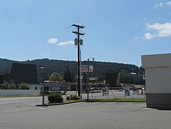
Rice Hill is a small, unincorporated community in Douglas County, Oregon, in the United States. An unincorporated community is a place that doesn't have its own local government. It's part of a larger county.
This community is located about 10 miles (16 km) north of Oakland. You can find it right along Interstate 5, a major highway. Rice Hill is a popular stop for travelers. It has places to eat, motels, and even a truck stop. Many people like to stop there for ice cream!
History of Rice Hill
Rice Hill got its name from early settlers. It was named either after Isadore F. Rice, who moved to the area in the 1850s, or William S. Rice. William Rice had a special land claim nearby around the same time.
A post office was opened in Rice Hill in 1892. It was later renamed "Ricehill" but closed down in 1908.
The area around Rice Hill was a challenge for early travelers. The land has a steep slope, which made it hard for pioneers to cross. This steepness also caused problems when the railroad was being built.
Geography of Rice Hill
Rice Hill is a summit, which means it's a high point of land. It acts like a natural divider between two water systems: Elk Creek and the Umpqua River.
South of the community, there's a valley that stretches for about two miles. The Central Oregon and Pacific Railroad (which used to be the Southern Pacific Railroad) has a station here. This station is also called Rice Hill.
The community sits at an elevation of about 710 feet (216 meters) above sea level. The land rises about 325 feet (99 meters) over a distance of 3 miles (4.8 km).
 | Laphonza Butler |
 | Daisy Bates |
 | Elizabeth Piper Ensley |


