
Richfield, Wisconsin facts for kids
Quick facts for kids
Richfield, Wisconsin
|
|
|---|---|

Location of Richfield in Washington County, Wisconsin.
|
|
| Country | |
| State | |
| County | Washington |
| Incorporated | February 13, 2008 |
| Area | |
| • Total | 36.47 sq mi (94.46 km2) |
| • Land | 35.92 sq mi (93.04 km2) |
| • Water | 0.55 sq mi (1.42 km2) |
| Elevation | 1,148 ft (350 m) |
| Population
(2020)
|
|
| • Total | 11,739 |
| • Density | 329.97/sq mi (127.40/km2) |
| Time zone | UTC-6 (Central (CST)) |
| • Summer (DST) | UTC-5 (CDT) |
| ZIP Code |
53076
|
| Area code(s) | 262 |
| FIPS code | 55-67475 |
| GNIS feature ID | 1584022 |
Richfield is a village located in Washington County, Wisconsin, in the United States. It sits on the edge of the larger Milwaukee Metropolitan Area, which is a big group of cities and towns. In 2020, about 11,739 people lived in Richfield.
Several smaller communities are part of Richfield. These include Hubertus, and parts of Colgate and Lake Five.
Contents
History of Richfield
Richfield was originally home to Native American tribes. These included the Menominee and Potawatomi peoples. They lived on this land for many years.
Early Settlers and Treaties
In 1831, the Menominee tribe gave up their land claims to the United States government. The Potawatomi tribe did the same in 1833. They were asked to leave the area by 1838. Many Native people moved west of the Mississippi River. However, some Potawatomi chose to stay in Wisconsin. They eventually formed the Forest County Potawatomi Community in northern Wisconsin.
The first white landowner in Richfield was Samuel Spivey. He bought land in 1841. Soon after, Jacob Snyder became the first white person to live there permanently. By 1843, many German immigrants began building farms in the area. They came mostly from a place called Hesse-Darmstadt.
Growth of the Community
In 1845, a group of German Catholics built the first church. They named it after Saint Hubertus. The community that grew around this church is now called Hubertus.
The area officially became the Town of Richfield in 1846. By 1848, most of the land was owned by Irish and German farmers. They mainly grew wheat until about 1880. After that, dairy farming became more popular in Richfield and across Wisconsin.
Railroad and Recreation
A railroad line was built through Richfield in 1855. This helped the local economy at first. However, the railroad company later failed. This caused problems for many local landowners.
In the early 1900s, people started building camps and fun places near the many lakes in Richfield. One example is YMCA Camp Minikani. It was founded in 1919 on Lake Amy Belle.
Becoming a Village
Richfield was mostly a farming area until the 1970s. Then, more people started moving from cities to the suburbs. This led to more homes being built and less farming. On November 6, 2007, people voted to change the town into a village. Richfield officially became a village on February 13, 2008.
Geography of Richfield
Richfield covers about 36.46 square miles (94.46 square kilometers). Most of this area is land, with a small part being water.
The lowest point in the village is at Little Cedar Creek. It is about 856 feet (261 meters) above sea level. The highest point is on Cheyenne Court. It is about 1,174 feet (358 meters) above sea level.
Lakes and Recreation
Richfield has six lakes where people can enjoy outdoor activities. The biggest lake is Friess Lake. Other lakes include Amy Belle, Bark Lake, Lake Five, Little Friess, and Mud Lake. YMCA Camp Minikani, a popular camp, is located on Lake Amy Belle.
Population Changes
The population of Richfield has grown a lot over the years.
| Historical population | |||
|---|---|---|---|
| Census | Pop. | %± | |
| 1900 | 1,617 | — | |
| 1910 | 1,615 | −0.1% | |
| 1920 | 1,467 | −9.2% | |
| 1930 | 1,487 | 1.4% | |
| 1940 | 1,564 | 5.2% | |
| 1950 | 2,077 | 32.8% | |
| 1960 | 3,172 | 52.7% | |
| 1970 | 5,923 | 86.7% | |
| 1980 | 8,390 | 41.7% | |
| 1990 | 8,993 | 7.2% | |
| 2000 | 10,373 | 15.3% | |
| 2010 | 11,300 | 8.9% | |
| 2020 | 11,739 | 3.9% | |
| U.S. Decennial Census | |||
Richfield's Population in 2010
In 2010, there were 11,300 people living in Richfield. There were 4,170 households, which are groups of people living together. Most households (75.6%) were married couples. About 34.1% of households had children under 18.
The average age of people in Richfield was 45 years old. About 23.9% of residents were under 18. About 12.5% were 65 years or older. Slightly more than half of the population (51.1%) was male, and 48.9% was female.
Education in Richfield
Richfield is served by two main school districts: the Holy Hill Area School District and the Germantown School District.
The Holy Hill Area School District includes Friess Lake Elementary School and Richfield Middle School. Students from this district then go to Hartford Union High School. Amy Belle Elementary School is in the Germantown School District.
Transportation
The Riteway Bus Service has its main office in Richfield. A former railroad line, once part of the Milwaukee Road, also runs through the village.
Notable People from Richfield
- Josh Bilicki, a professional racing driver.
Images for kids
-
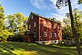
The Messer-Mayer Gristmill was built on Coney Creek in Richfield in 1871-73. The building is listed on the National Register of Historic Places.
-
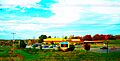
Friess Lake School


See also
 In Spanish: Richfield (Wisconsin) para niños
