Richmond Heights, Missouri facts for kids
Quick facts for kids
Richmond Heights, Missouri
|
|
|---|---|

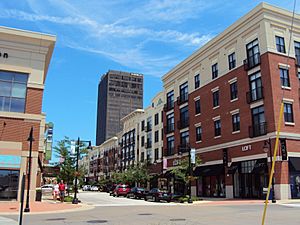
The Boulevard shopping area, June 2010
|
|

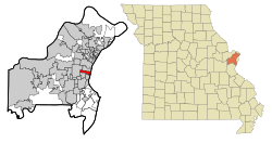
Location of Richmond Heights, Missouri
|
|
| Country | United States |
| State | Missouri |
| County | St. Louis |
| Government | |
| • Type | Council-Manager |
| Area | |
| • Total | 2.29 sq mi (5.93 km2) |
| • Land | 2.29 sq mi (5.93 km2) |
| • Water | 0.00 sq mi (0.00 km2) |
| Elevation | 495 ft (151 m) |
| Population
(2020)
|
|
| • Total | 9,286 |
| • Density | 4,053.25/sq mi (1,565.30/km2) |
| Time zone | UTC-6 (Central (CST)) |
| • Summer (DST) | UTC-5 (CDT) |
| ZIP code |
63117
|
| Area code(s) | 314 |
| FIPS code | 29-61706 |
| GNIS feature ID | 2396370 |
| Website | http://www.richmondheights.org/ |
Richmond Heights is a city in St. Louis County, Missouri. It's like a neighborhood right next to the bigger city of St. Louis, Missouri, in the United States. Its population grew from about 8,600 people in 2010 to over 9,200 people in 2020. The city's name was suggested by Robert E. Lee. He thought the area looked a lot like Richmond, Virginia.
Contents
About the City's Land
Richmond Heights covers about 2.3 square miles (5.9 square kilometers) of land. It has no large bodies of water.
Major Roads in Richmond Heights
Important highways like Interstate 170, Interstate 64, and U.S. Route 40 pass through Richmond Heights. These roads help people travel easily in and out of the city.
Who Lives in Richmond Heights?
| Historical population | |||
|---|---|---|---|
| Census | Pop. | %± | |
| 1920 | 2,136 | — | |
| 1930 | 9,150 | 328.4% | |
| 1940 | 12,802 | 39.9% | |
| 1950 | 15,045 | 17.5% | |
| 1960 | 15,622 | 3.8% | |
| 1970 | 13,802 | −11.7% | |
| 1980 | 11,516 | −16.6% | |
| 1990 | 10,448 | −9.3% | |
| 2000 | 9,602 | −8.1% | |
| 2010 | 8,603 | −10.4% | |
| 2020 | 9,286 | 7.9% | |
| U.S. Decennial Census | |||
Population in 2020
The 2020 United States census counted 9,286 people living in Richmond Heights. There were almost 4,000 households, which are groups of people living together. About half of these households were families.
Most people living here, about 78%, are white. About 8.7% are black or African-American, and 5.85% are Asian. Other groups make up smaller parts of the population. About 3.2% of the people are Hispanic or Latino.
About 17.7% of the people are under 18 years old. Many adults, about 38.2%, are between 25 and 44 years old. The average age in the city is about 36.7 years.
Population in 2010
In 2010, there were 8,603 people living in Richmond Heights. There were over 4,200 households. About 81.7% of the people were White, and 11.6% were African American. About 4.2% were Asian.
The average age in the city was 38.6 years. About 18.2% of the people were under 18. Many adults were between 25 and 44 years old.
Economy and Shopping
Richmond Heights has several important businesses and shopping areas. Panera Bread, a well-known restaurant chain, used to have its main office here.
The city is home to the Saint Louis Galleria, a large shopping mall. This mall is a big source of income for the city. You can also find a hospital, a movie theater, and many smaller shops and businesses.
Getting Around the City
Public Transportation
Richmond Heights has public transportation options. The Blue Line of the St. Louis light rail system serves the city. You can catch a train at the Richmond Heights station.
Main Roads and Highways
Besides the major highways, other important roads in Richmond Heights include Big Bend Boulevard, Brentwood Boulevard, and Clayton Road. These roads help people travel within the city.
Schools and Learning
Public schools in Richmond Heights are part of the Maplewood-Richmond Heights School District.
The city also has its own public library, called the Richmond Heights Memorial Library. It's a great place for residents to read and learn.
See also
 In Spanish: Richmond Heights (Misuri) para niños
 | Jessica Watkins |
 | Robert Henry Lawrence Jr. |
 | Mae Jemison |
 | Sian Proctor |
 | Guion Bluford |

