Ririe Reservoir facts for kids
Quick facts for kids Ririe Dam |
|
|---|---|

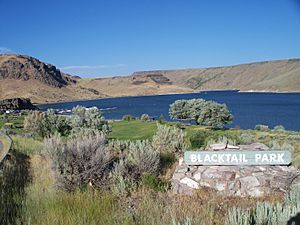
Blacktail Park, on the shore of the reservoir
|
|
| Official name | Ririe Dam |
| Location | Upper Snake River Basin, Bonneville County, Idaho, USA |
| Coordinates | 43°34′54″N 111°44′30″W / 43.58167°N 111.74167°W |
| Construction began | January 1970 |
| Opening date | February 1978 |
| Operator(s) | Bonneville County Parks & Recreation Department |
| Dam and spillways | |
| Impounds | Willow Creek |
| Height | 77.11 meters |
| Length | 326.14 meters |
| Width (base) | 15 meters |
| Reservoir | |
| Creates | Ririe Reservoir |
| Total capacity | 124,000 megaliters |
| Surface area | 6.1 km2 |
The Ririe Reservoir is a large lake created by the Ririe Dam near Ririe, Idaho. This important reservoir helps local farmers by providing water for their crops. It also protects the area from floods and offers many fun activities for people to enjoy.
Contents
Building the Ririe Dam
The Ririe Dam was built on a stream called Willow Creek. Construction began in January 1970. The United States Army Corps of Engineers started building it.
The dam officially opened in February 1978. It can hold over 124,000 megaliters of water. That's a huge amount of water!
New Building Methods
In 1972, something special happened at the Ririe Dam. Engineers used a new material called steel fibrous shotcrete for the first time. Shotcrete is a type of concrete that is sprayed through a hose. It was used to build a tunnel entrance, called an adit, at the dam. This was a big step forward in construction technology.
On October 14, 1976, the United States Bureau of Reclamation took over control of the dam. They are still in charge of managing it today.
Nature Around Ririe Reservoir
The land around the Ririe Dam is quite hilly. It is a type of environment called a shrub-steppe. This means it has lots of shrubs and grasses. You will see plants like sagebrush and bunch grass growing there. These plants are very common in this part of Idaho.
Fish in the Reservoir
The Ririe Reservoir is home to many different kinds of fish. It's a great spot for fishing! Some of the fish you might find include:
These fish make the reservoir a lively place for nature lovers and anglers.
 | George Robert Carruthers |
 | Patricia Bath |
 | Jan Ernst Matzeliger |
 | Alexander Miles |

