River Allen, Northumberland facts for kids
Quick facts for kids River Allen |
|
|---|---|

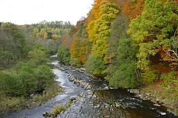
River Allen from the Cupola Bridge
54°55′36″N 2°18′50″W / 54.926596°N 2.313870°W |
|
|
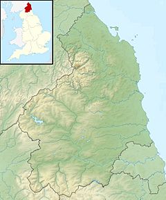
Location within Northumberland
|
|
| Country | United Kingdom |
| County | Northumberland |
| Physical characteristics | |
| River mouth | 54°58′38″N 2°18′41″W / 54.9771°N 2.3115°W |
| Length | 5 miles (8 km) |
| Basin features | |
| River system | River Tyne |
The River Allen is a lovely river found in Northumberland, a county in England. It starts high up in the hills of the Northern Pennines. The river is actually formed when two smaller rivers, the East Allen and West Allen, join together. The River Allen then flows into a bigger river called the River Tyne.
For a long time, the River Allen had a lot of pollution from old mining activities. But, thanks to special clean-up projects, the water quality is much better now. This means the river is a great home for different kinds of wildlife, including cute voles and playful otters.
Contents
River Allen's Story
The River Allen is about 5 miles (8 km) long. It flows into the River South Tyne. We don't know exactly where the name "Allen" comes from. However, it gave its name to nearby places like Allendale and Allenheads.
The river is officially called the "Allen" from a spot known as Water Meetings. This place is just south of Cupola Bridge. Cupola Bridge is a very old bridge built in 1778. It is a grade II listed building, which means it's an important historical structure.
Where the River Begins
Before Water Meetings, the river is made up of two separate rivers: the River West Allen and the River East Allen. The River West Allen is about 5.6 miles (9 km) long. The River East Allen is longer, at about 14 miles (22 km).
Helping Wildlife and Fish
A group called Allen Valley Angling and Conservation helps people fish in the River East Allen. They also work hard to protect the river's wildlife. They try to improve the number of fish and make it easier for people to access the riverside.
The river is home to wild brown trout. You can also see sea trout and salmon swimming upstream to lay their eggs. Otters, which are clever river animals, also live here. In 2010, the conservation group removed old dams that were blocking the fish. They also added special "fish passes." These allow fish to swim further upstream than they could for over a hundred years! In 2017, they even released voles into the upper parts of the river.
Beautiful Scenery and Walks
The areas along the river are famous for their beautiful woodlands. There are lovely walks through the deep valleys and gorges that the river has carved out. A special place called Allen Banks and Staward Gorge is located upstream from where the River Allen joins the Tyne.
This gorge shows how powerful nature can be. It was formed by huge ice streams during the Devensian period, which was a very cold time in history. These ice streams cut their way through the rock, creating the deep gorge we see today.
Flooding and Nature's Comeback
In the winter of 2015/2016, a big storm called Storm Desmond caused severe flooding along the river. This meant the woodlands next to the river had to be closed to visitors. However, this closure had an interesting effect. More wildlife was seen around the river, including red squirrels, roe deer, and even more otters!
Past Pollution and Recovery
The River Allen used to suffer from pollution because of mining activities nearby. Both the East Allen and West Allen rivers had mines close to them. For example, the Allen Smelt Mill was on the south bank of the East Allen. This mining pollution caused problems for the river.
However, further downstream on the River Tyne, this pollution actually helped certain types of grasses grow. These grasses are special because they can grow well even with lead and zinc from the old mines in the water. Today, efforts have been made to clean up the river, making it much healthier for all its inhabitants.
River Flow and Water Levels
The main River Allen drains an area of about 8.1 square miles (21 km2). But if you include the West and East Allen rivers, the total area that drains into them is about 50 square miles (130 km2). As mentioned, the water quality has improved, but it was once affected by past mining.
Because a lot of water can flow into the river, and the valley walls are steep, the river can sometimes have "flash floods." This means the water level rises very quickly, which can cause problems downstream.
While there are no special measuring stations directly on the River Allen, there is one on the East Allen near Allendale. In normal weather, the river level there is usually between 7.1 inches (0.18 m) and 1 foot 8 inches (0.52 m). The highest water level ever recorded was in November 2000, when it reached 6 feet 5 inches (1.95 m).
Rivers Joining the Allen
Here are some of the smaller streams and rivers that flow into the River Allen:
- Linn Burn (joins from the right)
- Hood's Burn (joins from the left)
- Kingswood Burn (joins from the left)
- Harsondale Burn (joins from the right)
- Front Burn (joins from the left)
- River West Allen (joins from the left) - this is one of the main starting rivers
- River East Allen (joins from the right) - this is the other main starting river
 | Jessica Watkins |
 | Robert Henry Lawrence Jr. |
 | Mae Jemison |
 | Sian Proctor |
 | Guion Bluford |


