River Hart facts for kids
Quick facts for kids River Hart |
|
|---|---|

Just upstream of treated wastewater outfall of Hartley Wintney sewage treatment works
|
|
|
Mouth of the Hart (into the Whitewater)
|
|
| Country | England |
| Counties | Hampshire |
| Districts / Boroughs | Hart |
| Physical characteristics | |
| Main source | Crondall, Hampshire, United Kingdom 85 metres (279 ft) 51°14′07″N 0°51′33″W / 51.23524°N 0.85920°W |
| River mouth | River Whitewater Hart, Hampshire 46 metres (151 ft) 51°20′32″N 0°56′13″W / 51.34224°N 0.93683°W |
| Basin features | |
| Progression | Hart, Whitewater, Blackwater, Loddon, Thames |
| Tributaries |
|
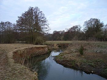
The River Hart is a small river in northern Hampshire, England. It is a branch of the River Whitewater. The river starts from a spring called Ashley Head in Crondall. It then flows north until it meets the Whitewater at Bramshill.
The Hart district in Hampshire is named after this river.
Contents
Where the River Hart Flows
The River Hart begins from several springs on Crondall golf course. These springs are about 85 meters (279 feet) above sea level. The main spring is called Ashley Head. From there, the river flows north, passing through areas with houses. It goes under Redlands Lane and then under the driveway of East Bridge House. This house is an old mansion from the early 1800s.
The river then flows past Marsh Farm Business Centre and through fields. It goes under the Basingstoke Canal near Crookham Wharf. After running behind houses on Crondall Road, it flows under the road itself. Here, another small stream joins the Hart from its left side.
Itchel Mill Springs Tributary
This smaller stream starts from springs and ponds known as Itchel Mill Springs. The water from these springs flows under the A287 road. It then reaches the spot where an old mill used to be. This mill was taken down in 1945. A modern house now stands where the mill cottage once was. The stream then winds through Coxmoor Farm. It also passes under the Basingstoke Canal and through Peatmoor Copse. Another small stream joins it here before it reaches the main River Hart.
Pilcot Mill and Beyond
Further along the river is Pilcot Mill at Dogmersfield. This millhouse has two floors and was built in the 1700s. It was last used for milling in 1928. Its small cottage has parts that are even older, from the 1600s. Downstream from Pilcot Bridge, there is a large old timber-framed house. It is known as Catherine of Aragon House.
The river then flows past Pilcot farm on its left side. It continues through fields west of Fleet, often lined with trees. Many ditches add water to the river here. The river then splits into two parts to flow under the South Western main line railway embankment. Fields are drained by the river up to the M3 motorway. A main ditch starts near the motorway and runs next to the river on its left side. Both the river and this ditch go under the A323 Fleet Road. They are controlled by special gates called sluices as they enter Elvetham Park.
Elvetham Park
Elvetham Park was first created in the 1300s. In 1591, it was redesigned for Edward Seymour. He used it to host Elizabeth I for four days of big parties. Guests even got a booklet describing the fun! In the 1700s and early 1800s, the park grew bigger. More trees were planted, and fancy gardens were added later in the 1800s and early 1900s.
The original Elvetham House burned down in 1840. A new building, Elvetham Hall, was built between 1859 and 1862. It is a very important old building. More parts were added to the hall in 1901 and 1911–12. The park also has a church that looks like a Norman building. It was built in 1840. The River Hart flows through the park. It separates Elvetham Park to the south-east from New Park to the north-west.
A lake was built in 1871 near the hall. By the 1980s, this lake had become very overgrown with plants. So, a small dam (weir) and a bypass channel were built. This allowed the river to be sent around the lake so it could be cleaned out. A bridge was also built over the river in the park. It has two brick arches and iron gates.
Journey's End
As the river leaves Elvetham Park, the Fleet Brook joins it from the right. Hartford Bridge carries the A30 road over the river at the small village of Hartfordbridge. Soon after, treated water from the Hartley Wintney sewage works flows into the river. The Hart continues through wooded areas.
It then enters Bramshill Park, which is a very important historical site. In 1347, Thomas Foxley enclosed 2,500 acres (1,000 hectares) of land here to create a deer park. He later built a house. A diplomat named Edward, Lord Zouche, bought it in 1605. He built a large mansion between 1605 and 1612, using parts of the old house. The park was designed in the 1600s. In the late 1700s and early 1800s, the river was made wider to form a large body of water called the Broad Water.
The estate was sold in 1952. Parts of it became a Police Training College. The park has a very important water garden from the early 1600s. The mansion is one of only three buildings from that time known to have two special apartments. One was for the king and one for the queen. Inside the park, there is also a very important bridge crossing the river. It was built in the early 1800s. It has two red-brick arches and stone decorations. After leaving Bramshill Park, the river goes under Plough Lane at Lea Bridge. Finally, it joins the River Whitewater on its right side.
Milling on the Hart
For a long time, people used the River Hart to power water mills. These mills used the river's flow to grind corn into flour. We know of two such mills on the Hart. In 1871, both were corn mills. Today, only Pilcot Mill at Dogmersfield still stands.
Pilcot Mill
Pilcot Mill is a small building with three floors. It is made with a wooden frame and bricks. A mill in Dogmersfield was mentioned in the Domesday Book, which was written in 1086. However, that mill was probably a bit further downstream. There are records of a mill there from the 1400s, 1500s, and 1600s.
The mill building we see today is from the 1700s. It was last used for milling in 1928. In the 1980s, a lot of restoration work was done on the mill. Pilcot Mill was powered by a special type of water wheel outside the building. This wheel was very good at using the river's power. Today, the wheel is not in good condition. Inside the mill, all the old machinery and two sets of grinding stones are still there. It looks like an engine was also used to help power the mill sometimes. The river sometimes flooded, so there are two extra channels next to the wheel pit. These channels helped control the water.
Crondall Mills
There were also mills in Crondall, below Itchel Mill Springs. A mill was there in 1068. It was worth three shillings (about 15 pence today). But by 1327, it was described as "an utter ruin and of no value." In 1653, two water mills were mentioned. In 1773, there were three grinding mills under one roof.
The last mill building was built before 1850. It was taken down in 1945. A modern house has replaced the old mill house next to it. The mill at Crondall could only work at certain times of the year. This is because its pond was fed by a spring that would dry up for part of the year. Usually, the pond would fill up in February. Then, milling could happen for several months after that.
Water Quality of the Hart
The Environment Agency checks the water quality of rivers. They give each river an overall "ecological status." This status has five levels: high, good, moderate, poor, and bad. To figure this out, they look at the types and numbers of living things in the water. This includes tiny creatures (invertebrates), plants, and fish. They also check the "chemical status." This means they compare the amount of different chemicals in the water to safe levels. Chemical status is either "good" or "fail."
Here's how the water quality of the River Hart system was in 2019:
| Section | Ecological Status | Chemical Status | Overall Status | Length | Catchment |
|---|---|---|---|---|---|
| Hart (Crondall to Elvetham) | Poor | Fail | Poor | 6.8 miles (10.9 km) | 17.35 square miles (44.9 km2) |
| Hart (Elvetham to Hartley Wintney) | Poor | Fail | Poor | 4.8 miles (7.7 km) | 4.60 square miles (11.9 km2) |
The water quality is not as good as it could be for several reasons. These include:
- Water released from sewage treatment works.
- Water running off from farms (agricultural land).
- Physical barriers like weirs (small dams) that stop fish and other creatures from moving freely.
- Water running off from roads.
- Chemicals leaking from old landfill sites.
External sources
 | George Robert Carruthers |
 | Patricia Bath |
 | Jan Ernst Matzeliger |
 | Alexander Miles |


