Fleet Brook facts for kids
Quick facts for kids Fleet Brook |
|
|---|---|

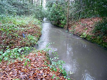
A long straight section of Fleet Brook below Fleet Pond
|
|
| Country | England |
| Counties | Hampshire |
| Districts / Boroughs | Hart |
| Physical characteristics | |
| Main source | Fleet Pond 51°17′31″N 0°49′46″W / 51.2920°N 0.8294°W |
| River mouth | River Hart Hartley Wintney 51°18′27″N 0°52′38″W / 51.3075°N 0.8773°W |
| Basin features | |
| Progression | Fleet Brook, Hart, Whitewater, Blackwater, Loddon, Thames |
| River system | Thames Basin |
Fleet Brook is a small river in northern Hampshire, England. It is a branch of the River Hart.
Contents
Where Does Fleet Brook Flow?
Fleet Brook starts near the town of Fleet. The main part of the river flows out from Fleet Pond. Other small streams flow into Fleet Pond. These streams are also considered part of Fleet Brook by the Environment Agency. The Environment Agency checks the water quality of these streams.
Streams Joining Fleet Pond
Several small streams feed into Fleet Pond.
The Eastern Streams
Some streams begin near reservoirs south-east of Fleet. They flow north, passing under Bourley Road. Another stream joins from a spring to the west. This stream is briefly called Gelvert Stream as it goes through a marshy area. More streams join before it crosses the A323 Norris Hill Road. It then flows under the Basingstoke Canal before reaching the south-eastern edge of Fleet Pond.
The Western Streams
A second stream starts in Greendane Copse. It flows underground for a bit, then reappears. It crosses housing areas in Church Crookham and Fleet. This stream is mostly hidden underground. But it has short open parts. In Oakley Park, you can see it again. It gets water from an overflow of the Basingstoke Canal. It then flows under the A323 road and Albany Road. It continues under three more bridges before flowing into the south-west corner of Fleet Pond.
The Southern Streams
A third stream begins in the Forest of Eversley. It used to be near a military sewage works. This stream flows past Fleet Infants School. The school building is special and protected. Its designers wanted to keep the nearby boggy land natural. This helps create a rich habitat for plants and animals. The stream then goes under the canal and through housing areas. It stays on the surface until Brooklyn Gardens. From there, it flows underground to reach Fleet Pond.
From Fleet Pond to River Hart
Fleet Pond is a nature reserve. It is a special area for wildlife. A small wall, called a weir, keeps the water level steady. The river flows out over this weir. It passes under the A3013 Cove Road. Then it runs next to Minley Road.
The river goes under Minley Road and through Broomhurst Wood. It flows under the M3 motorway. Here, another stream called Minley Brook joins it. Long ago, the main river used to go north from Minley Road Bridge. There was a mill and a millpond there. Now, office buildings stand on that spot.
Further on, the original river path is still there. It flows under Barley Way and the M3 motorway. It then winds between buildings at Brook House. This is where it joins Minley Brook. Brook House is a very old building. It was built before the town of Fleet even existed. It was known as Brook Farm in 1806. There are old brick walls from a moat near the house. These are important for history.
After Minley Brook joins, Fleet Brook flows west. Treated water from the Fleet sewage works also joins the river. The river then passes under Pale Lane Bridge. It winds through the countryside. Finally, it enters Elvetham Park. This is where it joins the River Hart.
Old Mills on Fleet Brook
There was at least one water mill on Fleet Brook. A map from 1759 shows "Fleet Mill" near Fleet Pond. It was a mill for grinding grain in 1872. The mill was used until about 1940. In 1990, experts checked if it should be a protected building. They decided it wasn't special enough. Now, office buildings are on the mill's site. But a small part of the old mill is still there.
Water Quality
The Environment Agency checks the water quality of rivers in England. They give each river a score. This score tells us how healthy the river is. The levels are: high, good, moderate, poor, and bad.
They look at:
- Biological status: This means checking the types and numbers of tiny creatures, plants, and fish in the water.
- Chemical status: This means checking if there are too many harmful chemicals in the water.
In 2019, the water quality of the Fleet Brook was:
| Section | Ecological Status | Chemical Status | Overall Status | Length | Catchment | Channel |
|---|---|---|---|---|---|---|
| Fleet Brook | Moderate | Fail | Moderate | 10.0 miles (16.1 km) | 12.77 square miles (33.1 km2) | heavily modified |
The table shows that Fleet Brook's water quality was "moderate" overall. The chemical status was "fail." This means there were too many chemicals.
Reasons for this water quality include:
- Water from sewage treatment works.
- Runoff from farms.
- Things like weirs that block fish from moving freely.
- Runoff from roads.
- Chemicals leaking from old landfill sites.
External sources
 | John T. Biggers |
 | Thomas Blackshear |
 | Mark Bradford |
 | Beverly Buchanan |


