
River Tutt facts for kids
Quick facts for kids River Tutt |
|
|---|---|

River Tutt in Boroughbridge
|
|

Location in North Yorkshire
|
|
| Other name(s) | Fleet Beck |
| Country | England |
| County | North Yorkshire |
| Physical characteristics | |
| Main source | Nidd 213 feet (65 m) 54°02′35″N 1°31′57″W / 54.0430°N 1.5326°W |
| River mouth | Boroughbridge 46 feet (14 m) 54°05′50″N 1°23′39″W / 54.0973°N 1.3942°W |
| Length | 8.7 miles (14 km) |
| Basin features | |
| River system | River Ure |
| Basin size | 17 square miles (45 km2) |
The River Tutt is a small but important river in North Yorkshire, England. It is about 8.7-mile (14 km) long. The River Tutt flows into the larger River Ure. It starts near the villages of Nidd and Scotton. The river mainly flows through farmland. It empties into the River Ure at a town called Boroughbridge.
The area where the River Tutt meets the River Ure has often experienced big floods. To help stop this, the Environment Agency has created special projects. These projects include building diversion channels and adding pumps. These efforts help protect Boroughbridge from flooding.
Contents
What Does the Name River Tutt Mean?
The river is called the Tutt for only about 4 miles (7 km) of its total length. In its early parts, it has different names. These names include Jumwell, Shaw, and Occaney Beck. It is also known as Tutt Beck, Fleet Beck, and Minskip Beck.
There are many ideas about where the name Tutt comes from. One idea is that it comes from an old Viking word. Another idea suggests it comes from a Roman goddess. This goddess, named Tutelina, was believed to protect stored corn.
A H Smith, who wrote about place names, said the name has been poorly translated. He suggested that the original name from 1439, Riovolum de Ptruth, might have changed. It could have come from an Old English word for 'conduit' (a channel for water).
Where Does the River Tutt Flow?
The River Tutt begins as Jumwell Beck. It starts east of the village of Nidd. This is about 1 mile (1.5 km) northeast of the River Nidd. However, it flows east towards Staveley, not south.
The river flows between the villages of Brearton and Scotton. Here, it is joined by Percy Beck from the south. It then takes in other small streams near Farnham. At this point, it becomes known as Shaw Beck. Later, it is called Occaney Beck as it passes the small village of Occaney.
As the river flows north of Staveley Nature Reserve, it appears on maps. It is listed as River Tutt or Fleet Beck. The Environment Agency, however, considers it the River Tutt from its start at Nidd. It flows northwest of Minskip. It then goes under the A1(M) motorway and the A168 road. Finally, it enters Boroughbridge and flows into the River Ure.
How the River Tutt Helps Prevent Flooding
Even though it is a small river, the River Tutt is an important part of the River Ure system. It can cause flooding in Boroughbridge when water from the Ure flows back upstream. This has happened many times in history. Major floods occurred in 1899, 1901, 1968, and 1982.
To stop this, the Tutt Diversion Scheme was put in place in 1987. This plan helps prevent water from the Ure from flowing up the Tutt. It works when either river, or both, are flooding. However, in January 2005, pumps meant to stop the Ure from flooding the Tutt were accidentally reversed. This put Boroughbridge at risk of another flood.
The area that the river drains is called its drainage basin. This basin covers about 17 square miles (45 km2). It is a lowland area, meaning it is not very high above sea level. Because of this, it gets less rain than other rivers that flow from nearby moorlands.
In the 13th century, there were two corn mills in Boroughbridge. One of them was located at the end of the River Tutt. During the 17th and 18th centuries, fishermen worked on the river. They fished near where it joins the Ure in Boroughbridge. The road by the rivermouth, Fishergate, is named after their trade.
What Is the Geology of the River Tutt Area?
In its early stages, the river flows over a type of rock called magnesian limestone. As it passes Staveley, it flows through farmland. This area mostly has open fields and not many trees.
The area around Occaney beck has been dug up in the past. People quarried it for sand and gravel deposits. These deposits were left by ancient rivers and glaciers. Other tests have also shown that there is sand in the area around the beck.
What Wildlife Lives in and Around the River Tutt?
The River Tutt is considered a "heavily modified" river. This means that human activities have changed it a lot. The Environment Agency and local volunteers have done much work to improve the river's condition.
The Yorkshire Wildlife Trust has also worked on the river. Thanks to their efforts, many animals have returned. These include otters and herons. They have also placed logs in the river near the lakes in Staveley. These logs provide safe places for fish to hide.
Even though the water quality is not perfect, fish like Cyprinid fish and brown trout are likely present. However, the river also has invasive plants. These include Himalayan Balsam and Giant Hogweed. Droppings from mink, another animal, have also been seen along the river.
The Environment Agency wants to send water from the Tutt into the lakes at Staveley. This would happen during heavy rainfall. It would help reduce the chance of flooding in Boroughbridge.
Bridges and Crossings Over the River Tutt
In the 17th century, one of the famous Devil's Arrows stones was cut down. This stone was then used to build a bridge over the river in Boroughbridge. Many people believe this bridge is the St Helena Bridge. A document from 1621 explains its purpose. This bridge also had special traps to catch eels on its upstream side.
The Fishergate Bridge was built by a famous engineer named Blind Jack Metcalf in 1754. However, this bridge and a nearby wall were washed away. This happened during a very big flood in 1883.
Images for kids
-
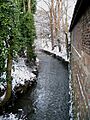
River Tutt in Boroughbridge
