
Rivière du Moulin (Beauceville) facts for kids
Quick facts for kids Rivière du Moulin |
|
|---|---|

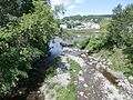
The Moulin river joining the Chaudière river in Beauceville
|
|

|
|
| Country | Canada |
| Province | Quebec |
| Region | Chaudière-Appalaches |
| MRC | Robert-Cliche Regional County Municipality, |
| Physical characteristics | |
| Main source | Forest streams Saint-Alfred 464 metres (1,522 ft) 46°08′32″N 70°48′42″W / 46.142355°N 70.811645°W |
| River mouth | Chaudière River Saint-Georges 249 metres (817 ft) 46°28′15″N 71°03′29″W / 46.47083°N 71.05805°W |
| Length | 28.4 kilometres (17.6 mi) |
| Basin features | |
| River system | St. Lawrence River |
| Tributaries |
|
The Rivière du Moulin (which means "River of the Mill" in English) is a river in Quebec, Canada. It flows into the Chaudière River, which then joins the mighty St. Lawrence River. This river runs through the towns of Saint-Alfred and Beauceville. It is part of the Robert-Cliche Regional County Municipality in the Chaudière-Appalaches region.
Contents
Where Does the Moulin River Flow?
The Moulin River starts from a lake called Volet Lake. This lake is found in a place called rang Saint-Guillaume in Saint-Alfred. Volet Lake is about 0.8 kilometers long and sits at an altitude of 265 meters. It is located southeast of the village of Saint-Alfred.

How the River Gets Its Water
Volet Lake gets its water from two main sources. One is the Bernard stream, which flows in from the east. The other is a stream from Lake Fortin, coming from the southwest. Lake Fortin is a popular spot for vacations. It is about 2.4 kilometers long and is 310 meters above sea level.
The River's Journey
From Volet Lake, the Moulin River travels about 8.4 kilometers. Here's how its journey unfolds:
- First, it flows 1.5 kilometers north. Along this part, it separates two areas: rang Saint-Guillaume on the west and rang Clark on the east. Here, another river called the Noire River joins it.
- Next, it flows 2.8 kilometers northeast. This section takes it to the border between Saint-Alfred and Beauceville.
- Then, it continues 3.0 kilometers north. Here, the ruisseau des Meules flows into it.
- Finally, it flows 1.2 kilometers northeast. It crosses Avenue Lambert, a road that runs along the west side of the Chaudière River. After this, the Moulin River meets the Chaudière River.
The Moulin River joins the Chaudière River in the town of Beauceville. This meeting point is about 0.7 kilometers south of the Beauceville town bridge.
What's in a Name?
The name "Rivière du Moulin" was officially recognized on December 5, 1968. This was done by the Commission de toponymie du Québec, which is a group in Quebec that names places.
Images for kids
-
The Moulin river joining the Chaudière river in Beauceville
