Roads in Charleston, West Virginia facts for kids

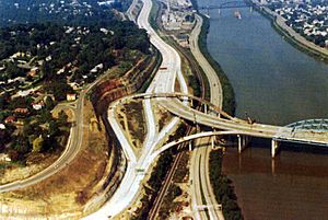
The U.S. Route 119 (Corridor G) Fort Hill interchange being built in 1973 in Charleston, West Virginia.

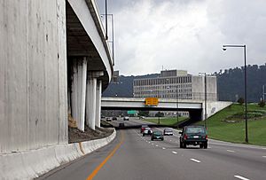
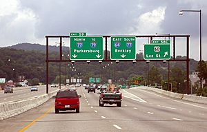
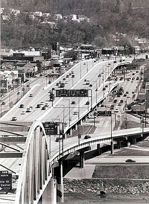
Interstate 64 and Interstate 77 at the WV 114 three-level interchange in Charleston, West Virginia. The lanes going west/north are on the left, sometimes hanging over the lanes going east/south.
|
The roads of Charleston, West Virginia are a big network. They include three main interstate highways, several U.S. highways, state routes, and many important local streets. These roads help people travel around the city and connect Charleston to other places.
Contents
Interstates
Interstate 64
Planning for Interstate 64 (I-64) in Charleston was quite difficult. People also had trouble deciding where Interstate 77 and Interstate 79 should go. This discussion started way back in the 1950s.
Many different paths were considered for the highway. Some ideas included building the road around the northern part of the Charleston area. Other ideas were to build it right through downtown or to the south of South Charleston.
By late 1971, a decision was finally made. The interstate would go through an area called the Triangle District. Many people did not agree with this choice.
Work on Interstate 64 through Charleston began in September 1971. To build the road, parts of 14 mountains were cut away. More than 1,000 homes on the south side of the Kanawha River had to be torn down.
One big part of the project was called the Fort Hill project. It was named after a hill behind the US 119 (Corridor G) interchange. This project involved moving a huge amount of earth. It was one of the biggest earth-moving projects in North America at that time.
Some parts of I-64 opened in 1974. In 1975, the Fort Hill interchange opened. Also, the high bridge (viaduct) in the Triangle District opened. This included the third bridge for Interstate 64 to cross the Kanawha River. Another steel bridge, the second one for the interstate over the Kanawha River, was the largest in the United States at that time.
The rest of Interstate 64 opened in 1976.
Interstate 77
Interstate 77 (I-77) enters Charleston near the Interstate 79 interchange. This is along the Elk River. The highway then turns south and becomes a six-lane expressway.
The connection with Interstate 64 was built in 1975. It is a three-level junction, which means it has roads at three different heights. This interchange goes over local streets. It is the biggest interchange in West Virginia. Its support columns are even built into buildings, over water, and over nearby streets.
One year later, the part of Interstate 77 from the Interstate 64 junction to the West Virginia Turnpike opened. This last section of interstate in Charleston has a special three-level part that hangs over other areas. It also has several flyovers and bridges that cross the nearby Kanawha River. This part of the road is also a backdrop for the state capitol buildings.
Interstate 79
Interstate 79 (I-79) only briefly enters the Charleston area. In 1979, the final part of this interstate in West Virginia was built. This section goes from Exit 9 to the Interstate 77 interchange. The large Y-shaped interchange with Interstate 77 is right next to the Elk River.
West Virginia Turnpike
The northern end of the West Virginia Turnpike is in Charleston. It finishes at Exit 95, which connects to WV 61 (MacCorkle Avenue).
The northern end used to be a trumpet-shaped interchange with a toll booth. However, it was rebuilt. This new design allows for easier connections to the newer Interstate 64/Interstate 77 road. This connection is east of the Capitol Complex.
U.S. Highways
U.S. Route 35
US 35 enters the Charleston area near Winfield. From West Virginia Route 34 in Winfield to I-64, US 35 has been changed. It is now a new four-lane freeway in Putnam County.
The old path that US 35 used to follow from Winfield to St. Albans is now called West Virginia Route 817. The current US 35 ends on I-64 at Exit 40.
U.S. Route 60
US 60 comes into Charleston on MacCorkle Avenue from St. Albans. It then goes east through South Charleston. It meets the Dunbar Bridge and then goes under the Interstate 64 bridge over the Kanawha River. In the middle of this area is the WV 601 intersection.
The road then passes through an industrial area. This area along the Kanawha valley has many chemical factories and manufacturing plants. After this, it meets WV 61. US 60 turns north to cross the Kanawha River and becomes Patrick Street. MacCorkle Avenue continues along WV 61.
US 60 keeps going north on Patrick Street. Then it heads east towards downtown along Washington Street. At the intersection with Edgewood Drive, US 60 splits. The eastbound (going east) lanes use Lee Street, while the westbound (going west) lanes use Washington Street. This is called a one-way pair.
At Pennsylvania Avenue, US 60 meets US 119 and the Interstate 64 high bridge. Then it crosses the Kanawha River to enter downtown Charleston.
At Brooks Street, Lee Street joins Washington Street again. This is near WV 114 (Greenbrier Street). Here, US 60 turns south for two blocks. Then it heads east along Kanawha Boulevard. It passes by the West Virginia State Capitol building. US 60 then connects with another part of US 60 east of Daniel Boone Park along the Kanawha River.
U.S. Route 119/Corridor G
U.S. Route 119 used to not go through South Charleston. However, it was marked along Oakhurst and Oakwood Roads. This happened when parts of Corridor G were being finished south of the city in the 1970s.
In 1975, the part of the road from Interstate 64 to Oakwood Road opened. This included the special ramp that goes over other roads, connecting US 119 to the Interstate 64 interchange. The part of the road between the WV 601 interchange and Oakwood Road in Charleston was finished in 1986.
State Routes
West Virginia Route 25
WV Route 25 starts at Iowa Street on the West Side of Charleston. It then goes through North Charleston as a four-lane road called 7th Avenue. When it leaves Charleston city limits, it follows Dunbar Avenue, 10th Street, and Fairlawn Ave. It goes through the city of Dunbar and the community of Institute. After Institute, Route 25 becomes 1st Avenue as it travels through Nitro. The route ends in the Putnam County community of Rock Branch. Here, it meets Route 62.
West Virginia Route 62
Route 62 begins just outside of Charleston city limits. This is between North Charleston and Dunbar. The road follows what used to be Route 35. Route 35 was moved to the south side of the river.
The road continues through the community of Cross Lanes. Then it goes into the city of Nitro and through the community of Rock Branch. At this point, the road starts to follow the north side of the Kanawha River. Then it heads north to the bridge crossing at Pomeroy, Ohio. From here, WV 62 shares its path with old US Route 33. This is because US Route 33 was rerouted north from Ripley, which is now where WV 62 ends.
West Virginia Route 114
WV 114 starts at US 60 (Washington Street). This is right next to the West Virginia Cultural Center and West Virginia State Capitol. It goes north as a four-lane highway. It connects with Interstate 64 and Interstate 77 at a three-level junction.
WV 114 has steep hills and many curves. This continues until it reaches the road that goes to Yeager Airport. After this, it becomes a two-lane road. It ends at Interstate 79 near Big Chimney.


