Roderfield, West Virginia facts for kids
Quick facts for kids
Roderfield
|
|
|---|---|
|
Census-designated place (CDP)
|
|

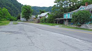
Davy Roderfield Road in Roderfield
|
|
| Country | United States |
| State | West Virginia |
| County | McDowell |
| Area | |
| • Total | 0.279 sq mi (0.72 km2) |
| • Land | 0.265 sq mi (0.69 km2) |
| • Water | 0.014 sq mi (0.04 km2) |
| Elevation | 1,129 ft (344 m) |
| Population
(2010)
|
|
| • Total | 188 |
| • Density | 673.8/sq mi (260.2/km2) |
| Time zone | UTC-5 (Eastern (EST)) |
| • Summer (DST) | UTC-4 (EDT) |
| ZIP code |
24881
|
| Area code(s) | 304 & 681 |
| GNIS feature ID | 1555514 |
Roderfield is a small community in McDowell County, West Virginia, United States. It is known as a census-designated place (CDP). A CDP is a special area that looks like a town but isn't officially governed as one.
Roderfield is located about 7 miles (11 km) west-northwest of Welch. It has its own post office with the ZIP code 24881. In 2010, the community had a population of 188 people.
History of Roderfield
Roderfield got its name from a person named Roderfield Iaeger. He was the first owner of the land where the community was built.
Location and Geography
Roderfield is nestled in the beautiful state of West Virginia. It is part of McDowell County, which is in the southern part of the state. The community is situated near the Tug Fork river.
Life in Roderfield
Even though it's a small place, Roderfield has a post office. This helps connect the community with the rest of the country. The area is known for its history as a coal town.
See also
 In Spanish: Roderfield (Virginia Occidental) para niños
 | Anna J. Cooper |
 | Mary McLeod Bethune |
 | Lillie Mae Bradford |


