Rodman Reservoir facts for kids
Quick facts for kids Rodman Impoundment |
|
|---|---|

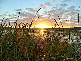
Sunrise on Rodman Reservoir
|
|
| Location | Putnam / Marion counties, Florida, United States |
| Coordinates | 29°30′26″N 81°54′59″W / 29.50722°N 81.91639°W |
| Type | reservoir |
| Primary inflows | Ocklawaha River |
| Primary outflows | Ocklawaha River |
| Basin countries | United States |
| Max. length | 16 mi (26 km) |
| Max. width | 3 mi (4.8 km) |
| Surface area | 13,000 acres (53 km2) |
| Average depth | 8 ft (2.4 m) |
| Max. depth | 30 ft (9.1 m) |
| Surface elevation | 20 ft (6.1 m) |
Rodman Reservoir, also known as Lake Ocklawaha, is a large, man-made lake in north central Florida. It is located on the Ocklawaha River, stretching across parts of Putnam County and Marion County. This lake is about 15 miles southwest of Palatka.
Rodman Reservoir is about 15 miles long and covers 13,000 acres. It sits between State Road 19 on the east and State Road 315 on the west. Many people consider it a top spot for catching largemouth bass in Northeast Florida.
Contents
Building Rodman Reservoir
The United States Army Corps of Engineers created Rodman Reservoir. Their goal was to make it easier for boats to travel along the Cross Florida Barge Canal. This canal was a big project planned to connect the Atlantic Ocean to the Gulf of Mexico.
How the Lake Was Made
Before the lake was filled, the Corps of Engineers used a huge machine called a "crusher-crawler." This machine helped clear parts of the forest along the Ocklawaha River. In 1968, they closed the Rodman Dam. This caused the river to flood the area, creating the reservoir. Many of the crushed trees floated to the top of the new lake.
The Cross Florida Barge Canal Project
The Rodman Dam and Reservoir were the first parts of a two-dam plan for the Cross Florida Barge Canal. However, the canal project faced strong opposition.
Protecting the Ocklawaha River
In 1971, a dedicated environmentalist named Marjorie Harris Carr worked with a group called Florida Defenders of the Environment (FDE). They worked hard to protect the Ocklawaha River. Because of their efforts, President Richard Nixon stopped the construction of the canal. Marjorie Harris Carr continued to work to protect and restore the Ocklawaha River until she passed away in 1997. The FDE group continues its work for a free-flowing Ocklawaha River even today.
Exploring Rodman Reservoir
The water levels in Rodman Reservoir are controlled by a four-gate spillway called Kirkpatrick Dam. This dam was later named the George Kirkpatrick Dam. It honors a Florida state senator who strongly supported the dam's creation.
Different Parts of the Lake
Rodman Reservoir has different sections, each with unique features:
- The area from Eureka Dam to Paynes Landing is mostly flooded woodlands.
- The section from Paynes Landing to Orange Springs has flooded standing trees and areas with floating plants.
- The main part of the lake, from Orange Springs to Kirkpatrick Dam, includes the old river channel and the part of the Cross Florida Barge Canal that was built. This area has floating and underwater plants, dead standing trees, and stumps.
Deep Waters and Plants
The old Barge Canal and the original river channel can be up to 30 feet deep. You can often find underwater plants like hydrilla, coontail, and eel grass in the deeper parts of the lake.
Managing the Lake
Every three to four years, the water levels in the reservoir are lowered on purpose. This process is called a "drawdown." It helps control the growth of water plants and improves the habitat for fish and other wildlife.
 | Frances Mary Albrier |
 | Whitney Young |
 | Muhammad Ali |


