
Ocklawaha River facts for kids
Quick facts for kids Ocklawaha River |
|
|---|---|

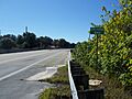
Looking north on CR 42
|
|

Ocklawaha River map
|
|
| Country | United States |
| State | Florida |
| Physical characteristics | |
| Main source | Harris chain of lakes 0 ft (0 m) |
| River mouth | St. Johns River |
| Length | 74 mi (119 km) |

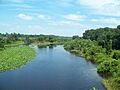
The Ocklawaha River is about 74 miles (119 kilometers) long. It flows north through central Florida and eventually joins the St. Johns River near a town called Palatka. The river's name comes from the Creek word ak-lowahe, which means "muddy".
Contents
Where the River Starts and Flows
The Ocklawaha River originally started from Lake Griffin. This lake is part of the Harris chain of lakes in Lake County, Florida. Today, the river gets water from the entire Harris Chain of Lakes. This includes Lake Eustis, Lake Harris, Lake Dora, Lake Beauclair, and Lake Apopka.
How Water Reaches the Ocklawaha
Water flows into the Ocklawaha through natural waterways and man-made canals. These include Haynes Creek, the Dead River, the Dora Canal, and the Apopka-Beauclair Canal. These canals have increased the amount of water flowing into the river. They have also increased the amount of pollution that runs into the river.
The River's Watershed Area
The Ocklawaha River's watershed covers a large area. It includes parts of the Green Swamp. It also covers most of Lake County. Plus, it includes parts of Marion, Alachua, and Putnam counties. The biggest lake in this watershed is Lake Apopka, which is near Orlando. This lake has faced challenges with water quality.
Important Streams Joining the Ocklawaha
The Ocklawaha River is the main stream that flows into the St. Johns River. The most famous stream joining the Ocklawaha is the Silver River. This river carries water from Silver Springs, a very clear natural spring.
Another important stream is Orange Creek. This creek starts from Orange Lake. Orange Lake gets its water from Lochloosa Lake through Cross Creek. It also gets water from Newnans Lake through Prairie Creek. Part of Prairie Creek's water is sent to Orange Lake. The rest flows to its original destination, Paynes Prairie.
History of River Travel
In the 1800s and early 1900s, the Ocklawaha River was very important for steamboat travel. A famous company called the Hart Line operated steamboats here. These steamboats were narrow so they could navigate the river's tight turns.
Popular Steamboat Tours
By the 1870s, a steamboat route from Palatka to Silver Springs became very popular. Many famous people traveled on this route. These included Harriet Beecher Stowe, Ulysses S. Grant, Thomas A. Edison, and Mary Todd Lincoln. They all wanted to visit Silver Springs. The scenic trip up the river made visiting Silver Springs an exciting adventure. However, the popularity of river travel decreased after railroads reached Ocala in 1881.
Most of the Ocklawaha River and its connecting streams can still be navigated. The Silver River is easy to access and very popular for boaters. Orange Creek can be explored by canoe for most of its length.
Locks and Canals
There are several ways to help boats navigate the river. These include:
- The Rodman Reservoir, where the river is held back by the Rodman Dam (now called the George Kirkpatrick Dam). Boats can pass through the Buckman Lock, which changes water levels by about 19 feet.
- The Burrell Lock and Dam on Haynes Creek.
- The Dora Canal.
- The Apopka-Beauclair Canal.
Most boat navigation stops before Lake Apopka.
Protecting the Ocklawaha River
The Ocklawaha River has faced environmental challenges. These include dams, pollution from fertilizers, dredging (digging up the riverbed), and changes to its path.
Stopping the Barge Canal
In the 1960s and 1970s, a woman named Marjorie Harris Carr led a successful effort. She helped stop the building of the Cross Florida Barge Canal. This canal would have dammed the river in two places. It would have created two artificial lakes for boats. Even though the canal was stopped, the river is still blocked by the Rodman Dam. The Florida Defenders of the Environment (FDE) group, which Carr helped start, still works to protect and restore the Ocklawaha River.
Fun Activities on the River
The Ocklawaha River is a great place for outdoor activities. People enjoy canoeing, kayaking, and fishing. The river forms the western edge of the Ocala National Forest.
Nature and Wildlife
Many parts of the river are still natural and untouched by people. The surrounding areas have lush forests and flatlands. You can find scrub pine trees and sandy soils. Lots of wild animals live here. You might see wild turkey, white-tailed deer, and various wading birds.
Outdoor Adventures
Besides paddling and fishing, other outdoor activities include hunting, watching wildlife, hiking, and horseback riding. However, there are not many marked trails in the area.
The Gores Landing unit of the Ocklawaha River Wildlife Management Area is nearly 3,000 acres (12 square kilometers). It is located along the Ocklawaha River in eastern Marion County. The Ocklawaha River basin is a main stream that flows into the St. Johns River Water Management District.
Images for kids
-
Looking north on CR 42
-
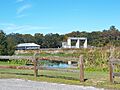
Moss Bluff Dam and Lock
-
CR 464C bridge at Moss Bluff


See also
 In Spanish: Río Ocklawaha para niños
