
Paynes Prairie Preserve State Park facts for kids
Quick facts for kids Paynes Prairie Preserve State Park |
|
|---|---|
|
IUCN Category V (Protected Landscape/Seascape)
|
|

Looking north from the Prairie observation tower
|
|

Paynes Prairie Preserve State Park
Location in Florida
|
|
| Location | Alachua County, Florida, United States |
| Nearest city | Gainesville, Florida |
| Area | 21,000 acres (85 km2) |
| Established | 1971 |
| Governing body | Florida Department of Environmental Protection |
| Designated: | December 1974 |
Paynes Prairie Preserve State Park is a special Florida State Park located in Alachua County, Florida. It's a huge, 21,000-acre (85 km2) savanna, which is like a grassy plain with scattered trees. You can find it between the towns of Micanopy and Gainesville.
This amazing place is also a U.S. National Natural Landmark, meaning it's a very important natural area. Major roads like I-75 and U.S. 441 cross through it, and U.S. 441 even has a special viewing spot!
Paynes Prairie is in the middle of a basin, which is like a big bowl in the land. Water usually drains into a place called Alachua Sink. Sometimes, after a lot of rain, the basin fills up and becomes a temporary lake called Alachua Lake. This happened a lot between 1871 and 1891, when small steamboats could even travel across the lake!
The area was once known as the Alachua Savannah. Over time, people built canals to control the water flow. Since 1927, Camps Canal has connected the basin to the River Styx, which leads to Orange Lake and eventually the Atlantic Ocean. This changed how much water the prairie received. In 1970, the state of Florida bought the land and has been working hard to bring it back to its natural state.
Heavy rains can still bring Alachua Lake back. For example, in September 2017, Hurricane Irma caused a lot of flooding, turning much of the basin into a lake for months!
Contents
History of Paynes Prairie
Early Days: La Chua Ranch
Long ago, before 1637, a Spanish official named Francisco Menéndez Márquez started a huge cattle ranch called La Chua ranch near Paynes Prairie. It was about 87 square miles (230 km2) big and became the largest ranch in Spanish Florida. Native groups and French pirates sometimes attacked it, and it was eventually left empty by 1706.
Seminole Home: Cuscowilla and Paynes Town
By the mid-1700s, Paynes Prairie became the home of the Alachua band of the Seminole tribe. Their chief was Ahaya the Cowkeeper. The Seminole town of Cuscowilla was close to where Micanopy is today.
In 1774, a traveler named William Bartram visited the area, then called Alachua Savannah. He wrote in his book, "Bartram's Travels", that the Seminole used the prairie to graze their animals.
By the 1790s, Cuscowilla moved and became known as Paynes Town. The town and the prairie were named after Chief Cowkeeper's son, Payne. In 1813, Paynes Town was destroyed. Later, during the Second Seminole War, two forts, Fort Tarver and Ford Crane, were located in Paynes Prairie.
After the Seminole people were moved, European Americans and their slaves settled in the area. A railroad line was built along the northern edge of the prairie in the late 1800s.
The Disappearing Lake
In 1871, something interesting happened: Alachua Sink got blocked! This caused the basin to fill up and become Alachua Lake for several years. From 1871 to 1891, the lake was deep enough for steamboats to travel on it.
But around 1889, the lake started to shrink. In July and August 1891, the water levels dropped very quickly. The lake became much smaller, leaving dead fish and alligators on its banks. One steamboat even got stuck! Similar events had happened before, in 1823 and 1870.
Changes by Camp Ranch
By the 1920s, a company called Camp Ranch, Inc. owned most of the prairie. In 1927, they built canals to move water away from Paynes Prairie to Orange Lake. This meant the prairie lost half of its surface water supply. That same year, U.S. 441 was built through the basin.
In 1937, Camp Ranch started another canal, the Sweetwater Branch Canal. This canal sent water directly into Alachua Sink instead of letting it spread out into Lake Alachua. As Gainesville grew, more stormwater and pollution flowed into this canal. In 1964, I-75 was built through the western part of the prairie.
Protecting and Restoring the Prairie
In 1970, the state of Florida bought the land from Camp Ranch, Inc. In December 1974, it was named a National Natural Landmark. In 1975, the Florida Park Service started to bring back some of the natural water flow. During the 1970s and 1980s, officials also brought back several animal species to Paynes Prairie.
Today, Paynes Prairie gets its water from different sources, including Newnans Lake and direct rainfall. Efforts are being made to remove old canals and dikes to help the prairie return to its natural water flow.
A special project called the Sweetwater Wetlands Park was built in the mid-2010s. This 125-acre wetland helps clean the water flowing into Alachua Sink and restores the natural water flow to parts of the prairie. Sweetwater Wetlands Park opened in May 2015.
Nature and Wildlife
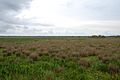
Paynes Prairie is part of the Southeastern conifer forests ecoregion. The prairie itself is a large freshwater marsh with different kinds of grassy plants. The types of plants change depending on how deep the water is.
In wet, forested areas, you can find bald cypress trees (Taxodium distichum) and swamp tupelo trees (Nyssa biflora). Along streams, there are forests with trees typical of blackwater rivers. On drier, higher ground, you'll see southern live oak trees (Quercus virginiana) and Florida longleaf pine sandhills on sandy soils.
Amazing Animals
Over 270 types of birds live in the park! You can also see American alligators and small groups of Florida Cracker horses and Florida Cracker cattle. These animals were first herded by the Seminole people, and the horses and cattle were brought back to the park in 1985.
One of the most exciting animals to see is the plains bison! These large animals were reintroduced to the park in 1975. They used to roam this area until the late 1700s. Park rangers brought them back to help restore Florida's natural environment to how it was before European settlers arrived. If you're lucky, you might spot them along the Cone's Dike trail. The park manages the bison herd to keep it healthy, aiming for about 8 to 10 bison to roam freely.
Fun Activities at the Park
The park has a visitor center with exhibits and a video that teaches you about the area's history and nature. There's also a 50-foot (15 m)-high observation tower near the visitor center. From the top, you get an amazing view of the whole preserve!
There are eight different trails for hiking, horseback riding, and bicycling. Park rangers lead special activities on weekends from November to April.
You can go fishing on Lake Wauburg, and there's a boat ramp for canoes and boats with electric motors. If you want to stay overnight, there are campsites available.
The Sweetwater Wetlands Project also has trails where you can walk and explore the wetland. It includes an outdoor classroom, another viewing tower, and a visitor center.
Paynes Prairie is a "gateway site" for the Great Florida Birding Trail, which means it's a great place to see many different birds.
Did you know? You could even see the space shuttle from Paynes Prairie about a minute after it launched!
The Gainesville-Hawthorne State Trail also goes through Paynes Prairie. Several scenic viewpoints off the trail let you look into the park. Sometimes, wildlife will come right up to the trail!
Park Hours
The park is located at 100 Savannah Blvd., Micanopy, FL 32667. Florida state parks are open every day of the year, including holidays, from 8 a.m. until sundown.
Water Flow in Paynes Prairie
Alachua Lake's water flows into the Florida aquifer, which is an underground water system. From there, the water travels northwest towards the Santa Fe River Basin. The prairie gets its water from many different places, including:
- Bivens Arm
- Sweetwater Branch
- Prairie Creek (which gets water from Newnans Lake)
- Chacala Run
- Chacala Pond (which gets water from Lake Wauburg)
- Dog Branch
Canals and Dikes
As of 2013, Paynes Prairie had about 38 miles of dikes (walls to control water) and 50 miles of canals (man-made waterways). These include:
- Camps Canal
- Cones Dike
- I-75 Dikes
- Sweetwater Branch Canal
- U.S. 441 Dikes
Gallery
-
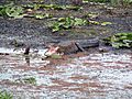
Just one of the many American alligators.
-
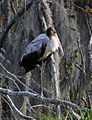
A wood stork at Paynes Prairie.
-
The US 441 overlook, facing east.
-
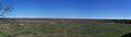
Panorama view from the observation tower.
-
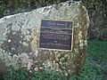
National Natural Landmark plaque.
-
View from the tower at the Bolen Bluff trail.
-
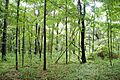
View from the forest of the Bolen Bluff trail.
-
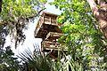
Paynes Prairie observation tower
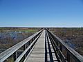
-
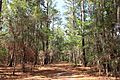
Paynes Prairie trail
-
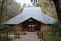
Visitor's center, front
-
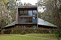
Visitor's center, back
-
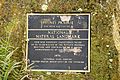
Plaque for National Natural Landmark


See also
 In Spanish: Paynes Prairie para niños
