
Roman Rig facts for kids
The Roman Rig is a very old and mysterious earthwork in South Yorkshire, England. People also call it the Roman Ridge, Scotland Balk, or Devil's Bank. It's a long line of raised ground that looks like a wall or a ditch. Experts believe it once stretched from Wincobank in Sheffield all the way to Mexborough.
We don't know exactly why or when it was built. For a long time, people thought it was a Roman road. But now, archaeologists have different ideas. They think it might have been built around the 1st century AD. This was when the Brigantian tribes might have used it to defend against the Roman invasion. Another idea is that it was built after the 5th century. This would have been to protect the kingdom of Elmet from invaders called the Angles.
Contents
What is the Roman Rig?
The Roman Rig is a series of earthworks. This means it's a structure made by moving large amounts of earth. It's like a long, raised bank or a ditch. People think it was originally a single, long dyke. A dyke is a wall or bank built to control water or for defense.
Where Can You See It?
The very start of the dyke might have been near Lady's Bridge in Sheffield. This is close to the River Don. Today, you can best see it near an ancient fort at Wincobank. This fort was built in the Iron Age.
The Roman Rig then goes northeast. It follows the Don Valley towards Kimberworth in Rotherham. Here, it splits into two parts. These two parts run almost side-by-side.
The Two Branches
The southern part of the Roman Rig goes through Greasbrough. It crosses the River Don just south of Swinton. This crossing point is at Kilnhurst.
The northern part goes near another Iron Age fort. This fort is at Scholes Coppice. It runs north of Swinton. This branch meets the River Don at Mexborough.
Old Boundaries
Parts of the Roman Rig were used a long time ago. In the Middle Ages, it helped mark borders. The western part of the ridge was a boundary. It separated the areas of Ecclesfield and Sheffield. This part runs next to the River Don.
An old report from 1891 said it once went as far west as Bridgehouses. The northern branch also formed a boundary. It separated Wath-on-Dearne from Rawmarsh and Swinton.
Images for kids
-
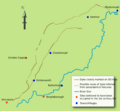
Plan of the Roman Ridge
-
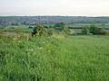
Earthworks near Greasbrough


