Rome, Missouri facts for kids
Quick facts for kids
Rome, Missouri
|
|
|---|---|
|
Community
|
|
| Country | U. S. A. |
| State | Missouri |
| County | Douglas County |
| Elevation | 290 m (950 ft) |
| Time zone | UTC-6 (CST) |
| • Summer (DST) | UTC-5 (CDT) |
Rome is a small, unincorporated community located in southern Douglas County, Missouri, in the United States. An unincorporated community is a place that does not have its own local government.
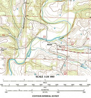
Rome is situated along Beaver Creek. It is about 10 miles southwest of Ava. You can find it on a county road, a short distance from the end of Route A. Rome is also about 3 miles west of Smallett. Other nearby places on Beaver Creek include Arno to the north and Brownbranch to the southwest.
Contents
History of Rome, Missouri
The area where Rome is now located has a long history. It was once home to important mills that helped early settlers.
Early Mills and Settlements
Around 1840, James Wright built a place called Wright's Mill here. This was likely the very first grist mill on Beaver Creek. A grist mill is a building where grain is ground into flour. Later, around 1850, William Lawrence built another mill in the same spot, known as Lawrence Mill.
Rome During the Civil War
During the Civil War, Lawrence Mill in Rome became an important location. Union soldiers built a small fort there to protect the area. This fort was called Fort Lawrence. It was a two-story building, about 100 feet long and 40 feet wide. Local soldiers, known as "Missouri home guards," defended the fort.
In January 1863, Confederate forces led by General Marmaduke attacked Fort Lawrence. They were on their way to Springfield. The Confederate soldiers burned down the fort during this attack.
Naming and Post Office
Rome had its own post office for many years, from 1888 until 1957. The community was named after the famous city of Rome, in Italy.
 | Isaac Myers |
 | D. Hamilton Jackson |
 | A. Philip Randolph |


