Rome metropolitan area, Georgia facts for kids
Quick facts for kids
Rome, Georgia metropolitan area
Rome, GA Metropolitan Area
|
|
|---|---|

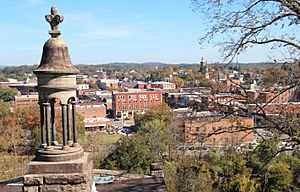
View of Rome from Myrtle Hill Cemetery
|
|
| Country | |
| State | |
| Time zone | UTC−5 (EST) |
| • Summer (DST) | UTC−4 (EDT) |
| ZIP codes |
300xx to 303xx
|
| Area codes | 404/678/470/943 inside the perimeter 770/678/470/943 outside the perimeter |
The Rome Metropolitan Statistical Area is a special area in the state of Georgia, in the United States. It's defined by the United States Census Bureau to help understand how people live and work together in a region. This area includes just one county: Floyd County.
This metropolitan area is located in Northwest Georgia. In the year 2000, about 90,565 people lived here. By 2009, the population had grown to an estimated 96,250 people.
Contents
What is a Metropolitan Area?
A Metropolitan Statistical Area (MSA) is a region that includes a large city and nearby communities. These communities are closely linked to the city through jobs and daily life. The main city in an MSA is called the "principal city."
Why are MSAs important?
MSAs help us understand how populations are spread out. They also show how different towns and cities are connected. This information is useful for planning and for businesses.
Counties in the Rome MSA
The Rome Metropolitan Statistical Area is made up of only one county. This county is a key part of the area's geography and community.
Communities in the Rome Area
The Rome Metropolitan Area includes several different types of communities. These range from official cities to smaller, less formal places.
Incorporated Cities and Towns
These are places that have their own local government. They have official city limits and provide services to their residents.
- City of Cave Spring: A smaller city within the metropolitan area.
- City of Rome: This is the main or "principal city" of the metropolitan area. It is the largest and most important city in the region.
Census-Designated Places (CDPs)
A census-designated place (CDP) is an area that looks like a town or community. However, it does not have its own local government. These places are counted by the Census Bureau for population data. All CDPs are unincorporated, meaning they are not officially part of a city or town.
Unincorporated Communities
These are areas where people live, but they are not part of any official city or town. They do not have their own local government. Services in these areas are usually provided by the county.
 | Laphonza Butler |
 | Daisy Bates |
 | Elizabeth Piper Ensley |

