
Romney, Indiana facts for kids
Quick facts for kids
Romney, Indiana
|
|
|---|---|

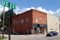
Post office at the corner of Main and High streets.
|
|

Tippecanoe County's location in Indiana
|
|

Romney, Indiana
Location in Tippecanoe County, Indiana
|
|
| Country | United States |
| State | Indiana |
| County | Tippecanoe |
| Township | Randolph |
| Area | |
| • Total | 0.88 sq mi (2.27 km2) |
| • Land | 0.88 sq mi (2.27 km2) |
| • Water | 0.00 sq mi (0.00 km2) |
| Elevation | 742 ft (226 m) |
| Population
(2020)
|
|
| • Total | 304 |
| • Density | 347.43/sq mi (134.21/km2) |
| Time zone | UTC-5 (Eastern (EST)) |
| • Summer (DST) | UTC-4 (EDT) |
| ZIP code |
47981
|
| Area code(s) | 765 |
| GNIS feature ID | 2813358 |
Romney is a small place in Indiana, a state in the United States. It's called an unincorporated community, which means it's not officially a town or city with its own local government. Instead, it's part of a larger area called Randolph Township in Tippecanoe County.
Romney is also considered part of the Lafayette Metropolitan Statistical Area. This just means it's near the city of Lafayette, Indiana and shares some economic and social connections with it.
History of Romney
Romney wasn't always called Romney! It was first known as Columbia. The community later got its current name from another place called Romney in West Virginia.
The post office in Romney has been helping people send and receive mail for a very long time. It first opened its doors way back in 1842.
Where is Romney Located?
Romney is found in Randolph Township. You can find it just south of where two main roads meet: U.S. Route 231 and State Road 28. This makes it easy to get to and from Romney.
People Living in Romney
| Historical population | |||
|---|---|---|---|
| Census | Pop. | %± | |
| 2020 | 304 | — | |
| U.S. Decennial Census | |||
According to the 2020 census, about 304 people live in Romney. This number helps us understand how many people call this community home.
Images for kids
-
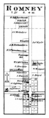
Romney in 1878, showing how it looked long ago.
-
A toy shop in Romney.

