
Roncador, Utuado, Puerto Rico facts for kids
Quick facts for kids
Roncador
|
|
|---|---|
|
Barrio
|
|

Bridge over Tanamá River in Roncador
|
|

Location of Roncador within the municipality of Utuado shown in red
|
|

Roncador, Utuado, Puerto Rico
Location in Caribbean
|
|
| Commonwealth | |
| Municipality | |
| Area | |
| • Total | 2.39 sq mi (6.2 km2) |
| • Land | 2.39 sq mi (6.2 km2) |
| • Water | 0 sq mi (0 km2) |
| Elevation | 1,230 ft (370 m) |
| Population
(2010)
|
|
| • Total | 637 |
| • Density | 266.5/sq mi (102.9/km2) |
| Source: 2010 Census | |
| Time zone | UTC−4 (AST) |
Roncador is a small area, called a barrio, in the town of Utuado, Puerto Rico. In 2010, about 637 people lived there. It is known for its natural beauty and peaceful environment.
A Look at Roncador's Past
Puerto Rico was once controlled by Spain. After the Spanish–American War in 1898, Spain gave Puerto Rico to the United States. This happened because of a special agreement called the Treaty of Paris of 1898.
Puerto Rico then became a territory of the United States. In 1899, the United States government counted all the people living in Puerto Rico. This count is called a census. The census showed that 1,130 people lived in Roncador barrio at that time.
| Historical population | |||
|---|---|---|---|
| Census | Pop. | %± | |
| 1900 | 1,130 | — | |
| 1980 | 459 | — | |
| 1990 | 488 | 6.3% | |
| 2000 | 579 | 18.6% | |
| 2010 | 637 | 10.0% | |
| U.S. Decennial Census 1899 (shown as 1900) 1910-1930 1930-1950 1980-2000 2010 |
|||
Pictures of Roncador
-
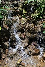
Spring water in Roncador

Find Out More
- In Spanish: Roncador (Utuado) para niños
- List of communities in Puerto Rico

All content from Kiddle encyclopedia articles (including the article images and facts) can be freely used under Attribution-ShareAlike license, unless stated otherwise. Cite this article:
Roncador, Utuado, Puerto Rico Facts for Kids. Kiddle Encyclopedia.