Roseto, Pennsylvania facts for kids
Quick facts for kids
Borough of Roseto
|
||
|---|---|---|

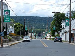
Garibaldi Avenue in Roseto in August 2015
|
||
|
||

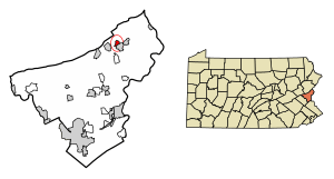
Location of Roseto in Northampton County, Pennsylvania (left) and of Northampton County in Pennsylvania (right)
|
||
| Country | ||
| State | ||
| County | Northampton | |
| Area | ||
| • City | 0.64 sq mi (1.64 km2) | |
| • Land | 0.63 sq mi (1.63 km2) | |
| • Water | 0.01 sq mi (0.02 km2) | |
| Elevation | 794 ft (242 m) | |
| Population
(2020)
|
||
| • City | 1,581 | |
| • Density | 2,513.51/sq mi (971.01/km2) | |
| • Metro | 865,310 (US: 68th) | |
| Time zone | UTC-5 (EST) | |
| • Summer (DST) | UTC-4 (EDT) | |
| ZIP Code |
18013
|
|
| Area code(s) | 610 and 484 | |
| FIPS code | 42-66168 | |
| School district | Bangor Area School District | |
| Website | boroughroseto.com | |
Roseto is a small town, also called a borough, in Northampton County, Pennsylvania. In 2020, about 1,581 people lived there. Roseto is part of a larger area called the Lehigh Valley metropolitan area. This area is home to over 860,000 people.
Roseto is famous in the world of science for something called the "Roseto effect". In the mid-1900s, scientists noticed that people in Roseto had much lower rates of heart disease than the national average. This was because of their strong, close-knit community. This discovery helped show that stress and social connections can affect your heart health.
Contents
History of Roseto
The name Roseto means "Rose garden" in Italian. The town is named after a village in Italy called Roseto Valfortore. Most of the first people who settled in Roseto, Pennsylvania, came from this Italian village. They started arriving in 1882.
Early Settlers and Work
These Italian immigrants came to work in the local slate quarries. Slate is a type of rock used for roofing and other building materials. In 1883, a railroad line opened through the town. This helped transport the slate and connect Roseto to other places. The railroad line was used until 1955. Roseto officially became a borough in 1912.
The Roseto Effect Study
In the early 1970s, a researcher named Carla Bianco studied Roseto. She compared it to the original Italian town, Roseto Valfortore. She found that most of Roseto, Pennsylvania's, 1,600 residents were still descendants of people from Roseto Valfortore.
Around the same time, a local doctor noticed how healthy the people in Roseto were. This led to a special study. The study found that the strong community ties and low stress levels helped people stay healthy. This important finding became known as the "Roseto effect" in public health.
Geography of Roseto
Roseto is located at 40°52′50″N 75°13′2″W / 40.88056°N 75.21722°W. The U.S. Census Bureau says the borough covers about 0.6 square miles (1.6 square kilometers). Only a tiny part of this area is water.
Transportation in Roseto
Roseto has several public roads. In 2017, there were about 9 miles (14.6 kilometers) of public roads. Some roads are kept up by the state, and others by the borough itself.
Main Roads
Two main highways serve Roseto: Pennsylvania Route 191 and Pennsylvania Route 512.
- PA 191 runs north and south through the eastern part of Roseto. It follows Roseto Avenue and First Street.
- PA 512 runs east and west along the southwestern edge of the borough. It follows Blue Valley Drive.
Population of Roseto
| Historical population | |||
|---|---|---|---|
| Census | Pop. | %± | |
| 1920 | 1,634 | — | |
| 1930 | 1,746 | 6.9% | |
| 1940 | 1,778 | 1.8% | |
| 1950 | 1,676 | −5.7% | |
| 1960 | 1,630 | −2.7% | |
| 1970 | 1,538 | −5.6% | |
| 1980 | 1,484 | −3.5% | |
| 1990 | 1,555 | 4.8% | |
| 2000 | 1,653 | 6.3% | |
| 2010 | 1,567 | −5.2% | |
| 2020 | 1,581 | 0.9% | |
| Sources: | |||
In 2000, there were 1,653 people living in Roseto. There were 640 households, which are groups of people living together. About 476 of these were families.
Population Breakdown
- Almost 99% of the people were White.
- A small number of people were Asian or African American.
- About 2% of the population was Hispanic or Latino.
In terms of age, the population was spread out:
- About 25% were under 18 years old.
- About 19% were 65 years or older.
- The average age was 38 years old.
Public Education in Roseto
Roseto is part of the Bangor Area School District.
- Students in grades 9 through 12 go to Bangor Area High School in Bangor.
- There is also a private school in the borough called Faith Christian School.
See also
 In Spanish: Roseto (Pensilvania) para niños
 | Toni Morrison |
 | Barack Obama |
 | Martin Luther King Jr. |
 | Ralph Bunche |


