
Rosholt, Wisconsin facts for kids
Quick facts for kids
Rosholt, Wisconsin
|
|
|---|---|
|
Village
|
|

Location of Rosholt in Portage County, Wisconsin.
|
|
| Country | |
| State | |
| County | Portage |
| Area | |
| • Total | 1.09 sq mi (2.81 km2) |
| • Land | 1.05 sq mi (2.72 km2) |
| • Water | 0.04 sq mi (0.09 km2) |
| Elevation | 1,138 ft (347 m) |
| Population
(2020)
|
|
| • Total | 478 |
| • Density | 462.86/sq mi (178.66/km2) |
| Time zone | UTC-6 (Central (CST)) |
| • Summer (DST) | UTC-5 (CDT) |
| ZIP code |
54473
|
| Area code(s) | 715 & 534 |
| FIPS code | 55-69575 |
| GNIS feature ID | 1572619 |
Rosholt is a small village located in Portage County, Wisconsin, in the United States. In 2020, about 478 people lived there.
Contents
History of Rosholt Village
The land where Rosholt is now was first owned by Gottlieb Stanbly. He received four 40-acre pieces of land from the U.S. Government in 1858 because he was a veteran.
Gottlieb Stanbly sold the land to Theodor Stanbly in 1861 for $430. Gottlieb then left to fight in the Civil War. Theodor later sold the land to Jens Rasmussen in 1867.
Jens Rasmussen built a millpond by blocking Flume Creek. He also built a mill that used water power to grind feed. This happened sometime between 1867 and 1881.
In 1884, John Gilbert (J.G.) Rosholt built the first sawmill in the area. It was on the east side of the millpond. He made a deal with Rasmussen to share the water.
J.G. Rosholt's first mill burned down in 1901. But it was quickly rebuilt in 1901 and 1902.
The first official map of Rosholt was made on June 1, 1903, at J.G. Rosholt's request. Rosholt became an official village in 1907. It was named after J.G. Rosholt, who became the first village president on April 7, 1908.
Geography and Location
Rosholt is located at 44°37′50″N 89°18′27″W / 44.63056°N 89.30750°W. This means it's in the northern part of the United States.
The United States Census Bureau says the village covers about 1.10 square miles (2.85 square kilometers). Most of this area, about 1.06 square miles (2.75 square kilometers), is land. The rest, about 0.04 square miles (0.10 square kilometers), is water.
Population and People
| Historical population | |||
|---|---|---|---|
| Census | Pop. | %± | |
| 1910 | 383 | — | |
| 1920 | 448 | 17.0% | |
| 1930 | 515 | 15.0% | |
| 1940 | 523 | 1.6% | |
| 1950 | 508 | −2.9% | |
| 1960 | 497 | −2.2% | |
| 1970 | 466 | −6.2% | |
| 1980 | 520 | 11.6% | |
| 1990 | 512 | −1.5% | |
| 2000 | 518 | 1.2% | |
| 2010 | 506 | −2.3% | |
| 2020 | 478 | −5.5% | |
| U.S. Decennial Census | |||
Rosholt's Population in 2010
In 2010, the census showed that 506 people lived in Rosholt. There were 208 households and 136 families.
Most people in the village (98.4%) were White. About 1.4% were Native American. A small number (0.2%) were from two or more races. About 3.2% of the population was Hispanic or Latino.
About 36.1% of households had children under 18 living with them. The average household had 2.43 people.
The average age of people in the village was 36.4 years. About 27.5% of residents were under 18 years old. About 12.1% were 65 years or older. The population was almost evenly split between males (50.8%) and females (49.2%).
Fun Events in Rosholt
Rosholt is known for its special events! Every year, on Labor Day weekend, the village hosts the Portage County/Rosholt/The Worlds Fair. This fair is for everyone and has games, food, carnival rides, and animal shows. There are also bands playing music and a slow-pitch softball tournament.
The fair park also hosts other events throughout the year. These include the Rosholt Fireworks on the Fourth of July, Good Times in the Pines, The Thresheree, and Bluegrass In The Pines. Bluegrass In The Pines is a festival for bluegrass music.
Gallery
-
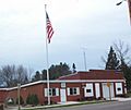
Village hall
-
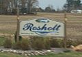
Welcome sign
-
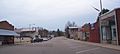
Downtown Rosholt


See also
 In Spanish: Rosholt (Wisconsin) para niños
