Rossburg, Ohio facts for kids
Quick facts for kids
Rossburg, Ohio
|
|
|---|---|
|
Village
|
|

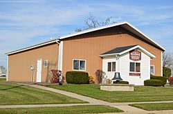
Village Hall
|
|

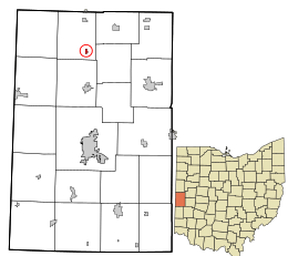
Location in Darke County and the state of Ohio
|
|
| Country | United States |
| State | Ohio |
| County | Darke |
| Township | Allen |
| Area | |
| • Total | 0.14 sq mi (0.36 km2) |
| • Land | 0.14 sq mi (0.36 km2) |
| • Water | 0.00 sq mi (0.00 km2) |
| Elevation | 1,040 ft (320 m) |
| Population
(2020)
|
|
| • Total | 159 |
| • Density | 1,135.71/sq mi (437.86/km2) |
| Time zone | UTC-5 (Eastern (EST)) |
| • Summer (DST) | UTC-4 (EDT) |
| ZIP codes |
45348, 45362
|
| Area code(s) | 937, 326 |
| FIPS code | 39-68672 |
| GNIS feature ID | 2399126 |
Rossburg is a small village located in Darke County, Ohio, in the United States. A village is a type of small community, often smaller than a town or city. In 2020, about 159 people lived in Rossburg.
Contents
The History of Rossburg Village
Rossburg was officially planned out by a person named John G. Ross in 1868. For a while, the community was also known as "Hagerman." A post office was opened there under the name Hagerman on December 19, 1883. It kept that name until November 4, 1905. Between 1881 and 1890, the village was also called Rossville.
Rossburg stayed quite small until around 1883. That's when a railroad company, which later became part of the Cincinnati, Jackson and Mackinaw Railroad, built train tracks through the village. This helped Rossburg grow and become more connected to other places.
Where is Rossburg Located?
Rossburg is a very small place. According to the United States Census Bureau, the village covers a total area of about 0.14 square miles (0.36 square kilometers). All of this area is land, meaning there are no lakes or large rivers within the village limits.
How Many People Live in Rossburg?
The number of people living in Rossburg has changed over the years. Here's a look at the population counts from different census reports:
| Historical population | |||
|---|---|---|---|
| Census | Pop. | %± | |
| 1890 | 254 | — | |
| 1900 | 251 | −1.2% | |
| 1910 | 261 | 4.0% | |
| 1920 | 246 | −5.7% | |
| 1930 | 176 | −28.5% | |
| 1940 | 204 | 15.9% | |
| 1950 | 203 | −0.5% | |
| 1960 | 295 | 45.3% | |
| 1970 | 275 | −6.8% | |
| 1980 | 260 | −5.5% | |
| 1990 | 250 | −3.8% | |
| 2000 | 224 | −10.4% | |
| 2010 | 201 | −10.3% | |
| 2020 | 159 | −20.9% | |
| U.S. Decennial Census | |||
Rossburg's Population in 2010
In 2010, the census showed that 201 people lived in Rossburg. There were 77 households, which are groups of people living together in one home. Most of these households (58) were families.
The village had about 1,436 people per square mile (554 people per square kilometer). This is called the population density. There were 81 housing units available.
Most people living in Rossburg in 2010 were White (100%). A very small number (0.5%) were of Hispanic or Latino background.
About 32.5% of the households had children under 18 living there. More than half (57.1%) were married couples living together. The average household had about 2.61 people, and the average family had about 3.03 people.
The average age of people in the village was 39.8 years old. About 22.4% of residents were under 18. About 10.4% were 65 years old or older. The village had slightly more males (50.7%) than females (49.3%).
See also
In Spanish: Rossburg (Ohio) para niños
 | Sharif Bey |
 | Hale Woodruff |
 | Richmond Barthé |
 | Purvis Young |

