Rothsville, Pennsylvania facts for kids
Quick facts for kids
Rothsville, Pennsylvania
|
|
|---|---|

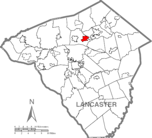
Location of Rothsville in Lancaster County, Pennsylvania
|
|
| Country | United States |
| State | Pennsylvania |
| County | Lancaster |
| Township | Warwick |
| Area | |
| • Total | 2.48 sq mi (6.43 km2) |
| • Land | 2.46 sq mi (6.38 km2) |
| • Water | 0.02 sq mi (0.04 km2) |
| Elevation | 490 ft (150 m) |
| Population
(2010)
|
|
| • Total | 3,044 |
| • Density | 1,235/sq mi (476.9/km2) |
| Time zone | UTC-5 (Eastern (EST)) |
| • Summer (DST) | UTC-4 (EDT) |
| ZIP Code |
17543 (Lititz)
|
| Area code(s) | 717 |
| FIPS code | 42-66392 |
| GNIS feature ID | 1185510 |
Rothsville is a small community in Lancaster County, Pennsylvania, United States. It is known as an unincorporated community. This means it is a place with a shared identity but no separate local government. It is also a census-designated place (CDP), which is an area the government defines for gathering population data. In 2010, about 3,044 people lived here. Even though it's Rothsville, residents use Lititz for their mailing addresses.
Contents
Rothsville's Early Days
Rothsville was started in 1790. A man named Philip Roth founded the community. He was one of the first people to settle there. Philip Roth also ran a tavern, which was a popular place for travelers and locals to gather.
Where is Rothsville?
Rothsville is located in the northern part of Lancaster County. It sits in the eastern section of Warwick Township. The main road through the community is Pennsylvania Route 772. This highway is also known as Main Street in Rothsville.
You can travel west on Route 772 for about 3 miles to reach Lititz. If you go southeast for about 2.5 miles, you'll get to U.S. Route 222 in Brownstown. Lancaster, the main city of the county, is about 10 miles to the south-southwest. Ephrata is about 4.5 miles to the northeast.
The total area of Rothsville is about 6.4 square kilometers. Most of this area is land. Only a small part, about 0.04 square kilometers, is water. Two creeks, Cocalico Creek and Hammer Creek, form the northeastern edge of Rothsville. They also mark the border with Ephrata Township. Lititz Run forms the southwestern border. Both Cocalico Creek and Lititz Run flow into the Conestoga River, which then joins the Susquehanna.
Getting Around Rothsville
Pennsylvania Route 772 is an important road that goes through Rothsville. This road was once part of an older route called the Mount Hope-Newport Road.
In the past, the Reading Railroad offered train rides from a station near Rothsville. This passenger service stopped in 1952. Today, you can find the Rail Trail where the old railroad tracks used to be. This trail runs through the northern part of Rothsville. It connects active parts of the rail line in Lititz and Ephrata, offering a great path for walking or biking.
Who Lives in Rothsville?
In 2000, about 3,017 people lived in Rothsville. There were 1,038 households, and most of these were families. Many households, about 46.6%, had children under 18 living with them. Most families, about 71.6%, were married couples living together.
The average household had about 2.91 people. The average family had about 3.21 people. The median age of people living in Rothsville was 34 years old. This means half the people were younger than 34, and half were older.
See also
 In Spanish: Rothsville para niños
 | Aaron Henry |
 | T. R. M. Howard |
 | Jesse Jackson |


