
Round Top (Alpine County, California) facts for kids
Quick facts for kids Round Top |
|
|---|---|

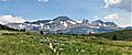
View to the west from the summit of Round Top. Carleton Watkins, 1879.
|
|
| Highest point | |
| Elevation | 10,381 feet (3,164 m) |
| Prominence | 2,541 feet (774 m) |
| Isolation | 13.66 miles (21.98 km) to Freel Peak |
| Parent peak | Highland Peak |
| Listing | Sierra Peaks Section |
| Geography | |
| Parent range | Sierra Nevada |
Round Top is a very tall mountain in California. It stands 10,381 feet (3,164 meters) high. You can find it in Alpine County, California, on the Sierra Nevada mountain range. This mountain is the highest point in the Eldorado National Forest and the Mokelumne Wilderness. It's also known for being one of the most prominent peaks in the Sierra Nevada.
Contents
How Round Top Formed
Round Top is actually what's left of an ancient volcano. This volcano was active a very long time ago, between 5 and 23 million years ago.
Most of the mountain you see today is a "volcanic plug." Imagine a giant stopper that formed inside the volcano. This plug was made when hot, melted rock (called magma) slowly cooled down underground. This rock is very strong and hard.
The top parts of the mountain are made from rocks that formed on the surface. These include layers from old lava flows and even some hardened mudflows. Over millions of years, wind and water wore away the softer parts of the volcano. But the hard volcanic plug and lava layers stayed strong. That's why Round Top still stands tall today!
Plants and Animals
The northern side of Round Top is home to several types of trees. You can find whitebark pine, western white pine, and lodgepole pine growing there.
As you go higher up the mountain, the trees become shorter and tougher. This is because the weather is very harsh. The whitebark pines can survive very high up, even in a twisted, stunted form called "krummholz." The very top of the mountain is above the tree line, meaning no trees can grow there.
A special plant called the Lake Tahoe lupine has even been found right at the summit of Round Top!
A Look Back in Time
People started exploring the area around Round Top for valuable minerals in 1872. They hoped to find gold or other treasures.
Later, in the 1870s, a scientist named George Davidson set up a special measuring station on the mountain's summit. This station was part of a big project to map out the Sierra Nevada mountains very accurately.
Climbing to the Top
Round Top is a popular mountain for climbers. It's listed on the Sierra Peaks Section list, which is a challenge for mountaineers.
Reaching the very top of Round Top requires a "Class 3" climb. This means you'll need to use your hands for balance and might encounter some steep, rocky sections. It's not just a simple walk! No one knows for sure who was the very first person to climb Round Top.
Images for kids
-
Round Top, seen from the north.
-
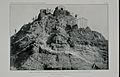
The summit of Round Top, California, in 1876. This was a triangulation station used for mapping.


