Row River facts for kids
Quick facts for kids Row River |
|
|---|---|

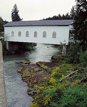
Dorena Bridge over the Row River
|
|
|
Location of the mouth of the Row River in Oregon
|
|
| Country | United States |
| State | Oregon |
| County | Lane |
| Physical characteristics | |
| Main source | Cascade Range Confluence of Brice Creek and Layng Creek, Lane County, Oregon 1,121 ft (342 m) 43°42′13″N 122°46′13″W / 43.70361°N 122.77028°W |
| River mouth | Coast Fork Willamette River near Cottage Grove, Lane County, Oregon, United States 617 ft (188 m) 43°49′14″N 123°02′36″W / 43.82056°N 123.04333°W |
| Length | 20 mi (32 km) |
The Row River is a river about 20 miles (32 km) long in Lane County, Oregon, United States. It starts in the Cascade Range mountains. The river then flows into the Coast Fork Willamette River near the town of Cottage Grove.
The river's name comes from a disagreement or "row" between two neighbors. This argument was about their livestock. The word "row" in the river's name rhymes with "cow," not "slow." A post office named Row River was open from 1911 to 1914 near where Dorena is today.
Contents
What is the Row River's Path?
The Row River is about 20 miles (32 km) long. It helps drain water from a part of the Umpqua National Forest. This forest is on the western side of the central Oregon Cascade mountains. The river flows between Cottage Grove and Oakridge.
Where Does the Row River Start?
The Row River begins near a small community called Disston. This is where two smaller streams, Layng Creek and Brice Creek, join together. From there, the river mostly flows towards the west.
Key Places Along the River
After about 1 mile (1.6 km) from Disston, Gleason Creek joins the Row River from the right side. About 1 mile (1.6 km) later, Hunt Creek also flows into the river from the right. The river then goes over Wildwood Falls, which is about 15 feet (4.6 m) high.
A short distance later, the river flows through Lasells D. Stewart Park. About 1 mile (1.6 km) after that, it passes through the community of Culp Creek. Here, Sharps Creek and then Culp Creek join the Row River from the left side.
The river then turns north. Hawley Creek joins from the left side just before the 15-mile (24 km) mark from the river's mouth. Soon after, the river flows through Dorena. At about 14 miles (23 km) from the mouth, Cedar Creek enters from the right.
The river then makes a sharp turn to the west. It passes a special measuring station used by the United States Geological Survey (USGS). This station is about 13.2 miles (21.2 km) from the river's mouth. The river then turns towards the northwest. Along this part of its journey, Pitcher Creek, King Creek, and Anderson Creek all join from the left. Finally, the river flows into Dorena Lake at about 11 miles (18 km) from its mouth.
The River's Journey Through Dorena Lake
While the Row River is part of Dorena Lake, several other streams join it. Vaughn Creek flows in from the left, and Smith Creek from the right. Bluff Creek joins from the left, Rat Creek from the right, and Baker Creek from the left. The river then reaches Dorena Dam and its spillway, which is about 7.5 miles (12.1 km) from the mouth.
After the dam, the river passes another USGS measuring station. This station is about 5.5 miles (8.9 km) from the river's mouth. Soon, Hann's Creek enters from the right.
In its last 5 miles (8 km), Mosby Creek joins the Row River from the left. The river then turns northwest. It flows past the Cottage Grove State Airport and goes under Interstate 5. Finally, the Row River flows into the Coast Fork Willamette River. This happens just below the larger river's 21-mile (34 km) mark.
How Much Water Flows in the Row River?
The USGS uses two special stations to measure how much water flows in the Row River. One station is near Dorena, about 13.2 miles (21.2 km) from where the river ends. The other is above Cottage Grove, about 5.5 miles (8.9 km) from the mouth.
Water Flow Near Dorena
At the Dorena measuring station, the river's average flow is about 589 cubic feet per second (16.7 m³/s). This measurement comes from a drainage area of about 211 square miles (546 km²).
The most water ever recorded flowing there was 33,100 cubic feet per second (937 m³/s). This happened on December 22, 1964. The least amount of water recorded was 9.7 cubic feet per second (0.27 m³/s). This low flow happened from September 4 to 6, 2003.
Water Flow Near Cottage Grove
At the Cottage Grove measuring station, the river's average flow is about 728 cubic feet per second (20.6 m³/s). This is from a larger drainage area of about 270 square miles (700 km²).
The highest flow recorded here was 21,400 cubic feet per second (606 m³/s) on December 28, 1945. The lowest flow was only 0.20 cubic feet per second (0.0057 m³/s). This very low flow occurred from September 25 to October 7, 1958.
 | William M. Jackson |
 | Juan E. Gilbert |
 | Neil deGrasse Tyson |


