Running Water Draw facts for kids
Quick facts for kids Running Water Draw |
|
|---|---|

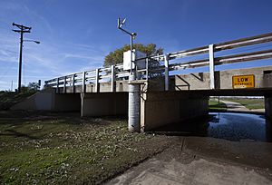
USGS gaging station in Running Water Draw
|
|
| Country | United States |
| Physical characteristics | |
| Main source | Curry County, New Mexico 4,565 ft (1,391 m) |
| River mouth | Floyd County, Texas 3,100 ft (940 m) |
| Length | 150 mi (240 km) |
| Basin features | |
| Basin size | 1,620 sq mi (4,200 km2) |
Running Water Draw is a special kind of waterway in the United States. It's called an ephemeral watercourse, which means it doesn't always have water flowing in it. Sometimes it's dry, and sometimes it fills up after rain! This draw is about 150 miles (240 km) long.
It starts in Curry County, New Mexico, near the city of Clovis. From there, it generally flows southeast into Texas. It eventually joins another waterway called Callahan Draw. Together, they form the beginning of the White River in Floyd County, Texas.
Where Does Running Water Draw Go?
Running Water Draw helps drain a large area of land, covering about 1,620 square miles (4,200 km²). This area is like a giant funnel that collects rainwater.
Counties It Crosses
As it travels, Running Water Draw passes through several counties. In New Mexico, it goes through Curry County, New Mexico. Then, in West Texas, it flows through:
This waterway is an important part of the natural landscape in these areas, even if it's not always full of water!
 | Kyle Baker |
 | Joseph Yoakum |
 | Laura Wheeler Waring |
 | Henry Ossawa Tanner |

