Ryan, Iowa facts for kids
Quick facts for kids
Ryan, Iowa
|
|
|---|---|

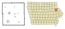
Location of Ryan, Iowa
|
|
| Country | |
| State | Iowa |
| County | Delaware |
| Area | |
| • Total | 0.44 sq mi (1.13 km2) |
| • Land | 0.44 sq mi (1.13 km2) |
| • Water | 0.00 sq mi (0.00 km2) |
| Elevation | 1,024 ft (312 m) |
| Population
(2020)
|
|
| • Total | 350 |
| • Density | 799.09/sq mi (308.80/km2) |
| Time zone | UTC-6 (Central (CST)) |
| • Summer (DST) | UTC-5 (CDT) |
| ZIP code |
52330
|
| Area code(s) | 563 |
| FIPS code | 19-69465 |
| GNIS feature ID | 0460870 |
Ryan is a small city located in Delaware County, Iowa, in the United States. In 2020, about 350 people lived there. It's a quiet place with a rich history.
Contents
Exploring Ryan's Location
Ryan is found at coordinates 42.350648 degrees North and 91.482986 degrees West. This means it's in the northern part of the United States.
How Big is Ryan?
According to the United States Census Bureau, Ryan covers a total area of about 0.43 square miles (1.13 square kilometers). All of this area is land, meaning there are no large lakes or rivers within the city limits.
A Look at Ryan's Past
Ryan was officially started on August 28, 1888. Three people named Arthur I. Flint, J. A. Thomas, and Andrew E. Anderson planned out the city. It became an official city in 1901.
The 1974 Tornado
On August 12, 1974, a very strong tornado hit Ryan. It was an F4 tornado, which means it was very powerful. The tornado caused a lot of damage, especially in the southern part of the city. Many homes were badly hurt. Buildings like the Great Plains Lumber Company, St. Patrick's Catholic Church, and the West Delaware grade school were also damaged. About 12 people were injured. The tornado caused an estimated $2.5 million in damage.
Changes to the City's Borders
Over time, Ryan has grown a little. After a new road called Iowa Highway 13 was built, the city added a small piece of land to its east side. This land used to be part of Hazel Green Township.
Who Lives in Ryan?
The number of people living in Ryan has changed over the years. Here's a quick look at its population history:
| Historical populations | ||
|---|---|---|
| Year | Pop. | ±% |
| 1910 | 511 | — |
| 1920 | 397 | −22.3% |
| 1930 | 369 | −7.1% |
| 1940 | 341 | −7.6% |
| 1950 | 362 | +6.2% |
| 1960 | 347 | −4.1% |
| 1970 | 343 | −1.2% |
| 1980 | 390 | +13.7% |
| 1990 | 382 | −2.1% |
| 2000 | 410 | +7.3% |
| 2010 | 361 | −12.0% |
| 2020 | 350 | −3.0% |
| Source: and Iowa Data Center Source: |
||
Ryan's Population in 2020
The census in 2020 counted 350 people living in Ryan. There were 149 households and 96 families. This means there were about 799 people per square mile. Most people (96.6%) were White. A small number of people were from other racial backgrounds. About 1.4% of the population identified as Hispanic or Latino.
Many households (30.9%) had children under 18 living with them. The average age of people in Ryan was 41.8 years old. About 25.7% of residents were under 20 years old.
Ryan's Population in 2010
In the census of 2010, there were 361 people living in Ryan. There were 152 households. About 99.2% of the people were White.
About 28.9% of households had children under 18. The average age was 37.9 years. About 23.3% of residents were under 18 years old.
Learning in Ryan
The local public schools in the Ryan area are managed by the West Delaware County Community School District.
Places to See
One interesting spot in Ryan is the Happy Chef Umpire, which is mentioned on the Roadside America website.
See also
 In Spanish: Ryan (Iowa) para niños
 | Dorothy Vaughan |
 | Charles Henry Turner |
 | Hildrus Poindexter |
 | Henry Cecil McBay |

