Ryer Island (Suisun Bay) facts for kids

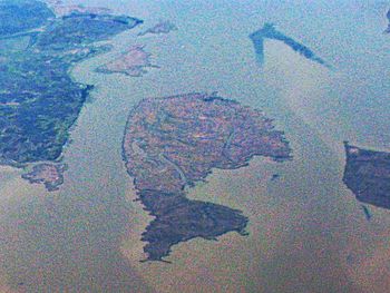
Ryer Island is the large, dolphin-shaped island in the center of this aerial photo. Directly above it and to the left is Freeman Island, and above Freeman Island is Snag Island. To its right is Roe Island.
|
|
| Geography | |
|---|---|
| Location | Northern California |
| Coordinates | 38°04′58″N 122°05′52″W / 38.08278°N 122.09778°W |
| Adjacent bodies of water | Suisun Bay |
| Administration | |
| State | |
| County | Solano |
Ryer Island is a cool island located in Suisun Bay, which is a part of the huge Sacramento-San Joaquin River Delta. You can find it in Solano County, California, about eight miles northeast of Benicia.
This island is managed by a group called Reclamation District 501. A "Reclamation District" is like a special local government that helps manage water and land, often by building levees to protect low-lying areas from floods. Ryer Island is also part of the Suisun Resource Conservation District, which works to protect and manage natural resources in the area.
A long time ago, when California first became a state, Ryer Island was known by a different name: Kings Island. You can even see it labeled as Kings Island on old maps from the 1850s, like one made by Cadwalader Ringgold and another by Henry Lange.
Contents
What is Ryer Island?
Ryer Island is one of many islands found in the Sacramento-San Joaquin River Delta. This delta is a very important area where two big rivers, the Sacramento and the San Joaquin, meet the Pacific Ocean. The delta is made up of many islands and waterways.
How are Delta Islands Formed?
Many delta islands, including Ryer Island, were formed over thousands of years. Rivers carried lots of mud and sand, which settled down and built up land. Over time, plants grew, and the land became solid enough to form islands.
Why are Delta Islands Important?
These islands are super important for many reasons. They provide homes for lots of wildlife, including birds, fish, and other animals. They also have rich soil, which is great for farming. Plus, they help manage water flow in the delta.
History of Ryer Island
Ryer Island has a long history, especially since it was first mapped in the 1850s. Back then, the area was still wild, and people were just starting to settle there.
Early Maps and Names
The fact that Ryer Island was called "Kings Island" on early maps tells us a bit about how places were named back then. Sometimes, islands were named after important people or features nearby. These old maps are like time capsules, showing us how the land looked and what people called it many years ago.
Managing the Land
Over time, people started to build levees around islands like Ryer Island. Levees are like big walls of earth that help keep water out, protecting the land from floods. This allowed people to farm on the islands and build homes. The Reclamation District 501 helps keep these levees strong and manages water for the island's residents and farmers.
Ryer Island Today
Today, Ryer Island continues to be an important part of the Sacramento-San Joaquin River Delta. It's a place where nature and human activity exist side by side.
What Can You Find There?
While Ryer Island is mostly rural, it's part of a beautiful natural area. The delta is popular for boating, fishing, and birdwatching. Many people enjoy exploring the waterways and seeing the different types of plants and animals that live there.
Protecting the Environment
The Suisun Resource Conservation District works hard to protect the natural environment of Ryer Island and the surrounding Suisun Bay. They help manage wetlands and other habitats to make sure that wildlife has a safe place to live. This also helps keep the water clean for everyone.
 | Laphonza Butler |
 | Daisy Bates |
 | Elizabeth Piper Ensley |


