
Sable Island facts for kids
Quick facts for kids
Sable Island
île de Sable
|
|
|---|---|

Island from Space Shuttle, April 1994. North is in the lower left corner.
|
|
| Country | Canada |
| Province | Nova Scotia |
| Municipality | Halifax Regional Municipality |
| District | 13 |
| Area | |
| • Land | 31 km2 (12 sq mi) |
| Population | |
| • Total | 0 (6-25 personnel from Meteorological Service of Canada are stationed on Sable Island on rotation at Sable Island Station only) |
| • Density | 0/km2 (0/sq mi) |
| Time zone | UTC−04:00 (AST) |
| • Summer (DST) | UTC−03:00 (ADT) |
| GNBC Code | CBRQR |
Sable Island (which means "island of sand" in French) is a small Canadian island. It is located about 300 kilometers (186 miles) southeast of Halifax, Nova Scotia, in the Atlantic Ocean. The island is famous for its wild horses and many shipwrecks.
Sable Island is a special place protected by Parks Canada. You need permission to visit it. A small team of federal government staff lives on the island all year. More people, like researchers and tourists, visit during the summer.
_p0187_SABLE_ISLAND.jpg)
Contents
History of Sable Island
Who First Found Sable Island?
Portuguese explorer João Álvares Fagundes explored this area around 1520. He was one of the first Europeans to see the island. He might have named it "Fagunda" after himself. Old maps show an island called Fagunda near where Sable Island is today.
Later, people who hunted seals, survivors of shipwrecks, and salvagers (people who saved things from wrecks) lived on the island sometimes.
The First Settlers on Sable Island
In 1598, a man named Troilus de La Roche de Mesgouez tried to start a colony. He left some convicts (people who had committed crimes) on Sable Island. The island had no trees or stones. Most of these settlers died. But a few survived for five years in mud homes. They were finally taken back to France in 1603.
Why Are There So Many Shipwrecks?
Sable Island is known for a huge number of shipwrecks. Experts believe about 350 ships have been lost on its sandbars. This happened because of thick fogs, dangerous currents, and the island's location. It sits right in the middle of a busy shipping route across the Atlantic Ocean.
The first recorded shipwreck was the English ship Delight in 1583. In 1736, a preacher named Rev. Robert Dunlap was shipwrecked there. In 1778, Lieutenant Anthony Kennedy and 25 men were stranded for a whole winter. Only two of them died, and the rest were rescued in April.
Lighthouses were built on each end of the island in 1873. This helped reduce the number of shipwrecks. The last big shipwreck was the steamship Manhasset in 1947. All her crew were saved.
In 1991, after a huge storm called the "Perfect Storm," parts of a fishing boat named Andrea Gail were found on Sable Island. All the crew members were lost at sea.
How Did the Rescue Station Start?
In 1801, the governor of Nova Scotia, John Wentworth, started life-saving stations on Sable Island. This began the continuous human presence on the island. James Morris, a veteran of the British Navy, became the first superintendent. He moved to the island with his family. By the time he died in 1809, he had built a main station, two rescue boat stations, and shelters for survivors.
In 1854, the rescue equipment was improved. This was thanks to a social reformer named Dorothea Dix. She helped raise money for new lifeboats and rescue cars.
Sable Island Today: Weather and Protection
After Canada became a country in 1867, the Canadian government took over the station. They added two lighthouses in 1872. The Marconi Company also set up a wireless radio station. The Canadian government then started a weather station.
As navigation improved, fewer ships wrecked. The rescue station closed in 1958. But the island's role in science grew. The weather station became a full meteorological station. It collected weather data until August 20, 2019. Scientists also study the island's unique plants and animals.
Sable Island is very important for its fragile environment. All visitors need special permission from Parks Canada. The island also has a heliport for emergency helicopters. It can be used as an evacuation point for workers on nearby oil and gas rigs.
Becoming a National Park
On October 17, 2011, Sable Island became a national park reserve. This means it has a high level of protection. Parks Canada now manages the island.
In July 2016, you could even explore Sable Island on Google Street View. Google worked with Parks Canada to add interactive views of the island.
Geography of Sable Island
What Does Sable Island Look Like?

Sable Island is a long, narrow, crescent-shaped sandbar. It is about 43 kilometers (27 miles) long but only 1.2 kilometers (0.75 miles) wide at its widest point. Its total area is about 34 square kilometers (13 square miles).
The island rises gently from the shallow waters of the continental shelf. It is about 285 kilometers (177 miles) east of Halifax, Nova Scotia. Because of its location, frequent fog, and strong storms, it is often called the Graveyard of the Atlantic. The closest land is about 160 kilometers (99 miles) away.
Sable Island is always changing shape. Waves erode the western side, and new sand is added to the eastern side. Strong winds and ocean storms also change its look.
Water on the Island
The island has some freshwater ponds on its south side. However, the protective sand dunes around them are eroding. This means the ponds are changing each year.
There used to be a large, slightly salty lake called Lake Wallace in the middle of the south beach. During World War II, small planes even landed on it. Over the years, the lake filled with sand and completely disappeared by late 2011.
Sable Island's Climate
Sable Island has a climate that is greatly affected by the sea. Winters are mild, with temperatures near freezing. Summers are cool, with daily high temperatures around 20°C (68°F). The ocean keeps the temperatures from changing too much.
The island gets about 1,372 millimeters (54 inches) of rain each year. Most of this rain comes from strong fall and winter storms. Thunderstorms are rare.
Sable Island is the foggiest place in the Maritimes. On average, it has 127 days with at least one hour of fog. This happens because the cold Labrador Current and the warm Gulf Stream meet near the island. The foggiest time is in the summer.
In winter, Sable Island is one of the warmest places in Canada, besides the Pacific coast. It is also the most hurricane-prone part of Canada. The highest temperature ever recorded was 27.8°C (82°F) on August 27, 1951. The lowest was -19.4°C (-2.9°F) on January 31, 1920.
| Climate data for Sable Island, 1981−2010 normals, extremes 1897−present | |||||||||||||
|---|---|---|---|---|---|---|---|---|---|---|---|---|---|
| Month | Jan | Feb | Mar | Apr | May | Jun | Jul | Aug | Sep | Oct | Nov | Dec | Year |
| Record high °C (°F) | 14.5 (58.1) |
12.8 (55.0) |
13.7 (56.7) |
13.9 (57.0) |
17.8 (64.0) |
21.7 (71.1) |
26.7 (80.1) |
27.8 (82.0) |
27.0 (80.6) |
22.8 (73.0) |
18.9 (66.0) |
15.6 (60.1) |
27.8 (82.0) |
| Mean daily maximum °C (°F) | 3.0 (37.4) |
1.8 (35.2) |
3.3 (37.9) |
6.5 (43.7) |
10.2 (50.4) |
14.2 (57.6) |
18.5 (65.3) |
20.7 (69.3) |
18.6 (65.5) |
14.3 (57.7) |
9.9 (49.8) |
5.5 (41.9) |
10.6 (51.1) |
| Daily mean °C (°F) | −0.1 (31.8) |
−1.2 (29.8) |
0.7 (33.3) |
4.0 (39.2) |
7.5 (45.5) |
11.4 (52.5) |
15.8 (60.4) |
17.9 (64.2) |
15.8 (60.4) |
11.7 (53.1) |
7.3 (45.1) |
2.5 (36.5) |
7.8 (46.0) |
| Mean daily minimum °C (°F) | −3.1 (26.4) |
−4.2 (24.4) |
−2.0 (28.4) |
1.5 (34.7) |
4.8 (40.6) |
8.6 (47.5) |
13.0 (55.4) |
15.1 (59.2) |
13.0 (55.4) |
9.1 (48.4) |
4.6 (40.3) |
−0.5 (31.1) |
5.0 (41.0) |
| Record low °C (°F) | −19.4 (−2.9) |
−18.3 (−0.9) |
−13.6 (7.5) |
−8.9 (16.0) |
−8.3 (17.1) |
0.6 (33.1) |
3.0 (37.4) |
4.4 (39.9) |
0.6 (33.1) |
−1.2 (29.8) |
−7.8 (18.0) |
−16.7 (1.9) |
−19.4 (−2.9) |
| Average precipitation mm (inches) | 144.7 (5.70) |
112.5 (4.43) |
130.4 (5.13) |
114.8 (4.52) |
101.3 (3.99) |
115.9 (4.56) |
100.8 (3.97) |
121.6 (4.79) |
129.5 (5.10) |
144.9 (5.70) |
150.7 (5.93) |
144.5 (5.69) |
1,511.6 (59.51) |
| Average rainfall mm (inches) | 110.4 (4.35) |
92.4 (3.64) |
107.7 (4.24) |
105.9 (4.17) |
101.2 (3.98) |
115.9 (4.56) |
100.8 (3.97) |
121.6 (4.79) |
129.5 (5.10) |
144.8 (5.70) |
145.1 (5.71) |
123.7 (4.87) |
1,399 (55.08) |
| Average snowfall cm (inches) | 33.3 (13.1) |
19.8 (7.8) |
22.1 (8.7) |
9.1 (3.6) |
0.1 (0.0) |
0.0 (0.0) |
0.0 (0.0) |
0.0 (0.0) |
0.0 (0.0) |
trace | 5.2 (2.0) |
18.6 (7.3) |
108.3 (42.6) |
| Average precipitation days (≥ 0.2 mm) | 20.4 | 16.8 | 16.7 | 16.0 | 14.5 | 13.9 | 13.5 | 12.0 | 12.4 | 16.2 | 19.3 | 19.8 | 191.5 |
| Average rainy days (≥ 0.2 mm) | 12.1 | 9.9 | 12.5 | 15.1 | 15.3 | 13.8 | 13.3 | 12.4 | 13.0 | 16.2 | 18.7 | 15.6 | 167.8 |
| Average snowy days (≥ 0.2 cm) | 11.6 | 10.0 | 7.2 | 2.6 | 0.19 | 0.0 | 0.0 | 0.0 | 0.0 | 0.06 | 2.8 | 8.6 | 43.0 |
| Mean monthly sunshine hours | 61.0 | 78.6 | 119.0 | 140.0 | 169.4 | 186.6 | 192.3 | 194.3 | 174.1 | 138.3 | 80.2 | 61.8 | 1,595.5 |
| Percent possible sunshine | 21.2 | 26.6 | 32.2 | 34.8 | 37.1 | 40.4 | 41.1 | 44.8 | 46.3 | 40.4 | 27.6 | 22.2 | 34.6 |
| Source: Environment Canada | |||||||||||||
Plants and Animals of Sable Island
What Plants Grow on Sable Island?

Sable Island is named after the French word for "sand." It does not have natural trees. Instead, it is covered with grass and other low-growing plants. In 1901, the government tried to plant over 80,000 trees, but they all died.
Only one Scots pine tree has survived from later plantings. It was planted in the 1960s and is still only a few feet tall. Station staff decorate it as a Christmas tree every December.
The Wild Horses of Sable Island
The island is home to over 550 wild horses. They are protected by law from human interference. These horses are thought to be descendants of horses taken from the Acadian people long ago. They were left on the island by a merchant named Thomas Hancock.
In the past, some horses were used by island patrols to find ships in trouble. They also helped move lifeboats and equipment to shipwreck sites. In 1960, the Canadian Government made a law to fully protect the horses. This means no one can interfere with them.
Seals and Other Animals

Harbour and grey seals breed on the island's shores. In the 1960s, about 200-300 grey seal pups were born there. By 2003-2004, this number grew to an estimated 50,000 pups!
Sharks sometimes hunt the seals in the nearby waters. Strange "corkscrew" bite marks on dead seals suggest that Greenland sharks are likely responsible for most attacks.
Many types of birds live on the island. These include the Arctic tern and the Ipswich sparrow. The Ipswich sparrow is a special type of Savannah sparrow that only breeds on Sable Island. Many other bird species visit the island during migration or after storms.
Long ago, there were also walruses on the island. But hunters drove them to extinction.
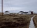
Sable Island Station

|
Sable Island
|
|||||||||||
|---|---|---|---|---|---|---|---|---|---|---|---|
| Summary | |||||||||||
| Airport type | Private | ||||||||||
| Owner | Parks Canada | ||||||||||
| Operator | Parks Canada | ||||||||||
| Location | Sable Island, Nova Scotia | ||||||||||
| Time zone | AST (UTC−04:00) | ||||||||||
| • Summer (DST) | ADT (UTC−03:00) | ||||||||||
| Elevation AMSL | 4 ft / 1 m | ||||||||||
| Coordinates | 43°55′59.8″N 060°00′25.2″W / 43.933278°N 60.007000°W | ||||||||||
| Map | |||||||||||

CSB2
Location in Canada
|
|||||||||||
| [[Helipad|]] | |||||||||||
|
|||||||||||
|
Source: Canada Flight Supplement
|
|||||||||||
The Sable Island Station is the only place on the island with permanent staff. Parks Canada manages it. Weather records have been kept on Sable Island since 1871.
Scientists have done a lot of research on Sable Island. They studied weather patterns and conditions high in the atmosphere. They also collected data on carbon dioxide levels. Research was done to track pollution and study fog chemistry.

A special magnetic observatory on Sable Island helps scientists study Earth's magnetic field. This data also helps the offshore energy industry with precise drilling.
Supplies are brought to the Sable Island Station about twice a month by plane. The island has a heliport for helicopters. There is no paved runway for planes. Instead, planes land on the south beach in an area called the Sable Island Aerodrome. You need permission to land, as the sand conditions can change and make it unusable.
Images for kids
-
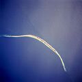
Island from Space Shuttle, April 1994. North is in the lower left corner.
-
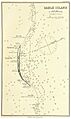
Nautical Chart, Atlantic Sea Pilot, 1884
-
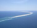
Sable Island from the northwest
-
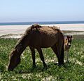
Sable Island horse and foal
-
Sable Island station
-
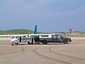
Britten-Norman Islander being unloaded on the beach at Sable Island
See also
 In Spanish: Isla Sable para niños
