
Sacaton, Arizona facts for kids
Quick facts for kids
Sacaton, Arizona
O'odham: Geʼe Ki:
|
|
|---|---|

The C. H. Cook Memorial Church, listed in the National Register of Historic Places
|
|

Location in Pinal County and the state of Arizona
|
|

Sacaton, Arizona
Location in the United States
|
|
| Country | United States |
| State | Arizona |
| County | Pinal |
| Area | |
| • Total | 9.29 sq mi (24.06 km2) |
| • Land | 9.29 sq mi (24.06 km2) |
| • Water | 0.00 sq mi (0.00 km2) |
| Elevation | 1,283 ft (391 m) |
| Population
(2020)
|
|
| • Total | 3,254 |
| • Density | 350.27/sq mi (135.23/km2) |
| Time zone | UTC-7 (MST (no DST)) |
| ZIP code |
85147
|
| Area code(s) | 520 |
| FIPS code | 04-61720 |
| GNIS feature ID | 10623 |
Sacaton is a special kind of town called a census-designated place (CDP) in Pinal County, Arizona, United States. Its name in the Pima language is Geʼe Ki:. In 2020, about 3,254 people lived here. Sacaton is important because it is the main town for the Gila River Indian Community.
Contents
Where is Sacaton Located?
Sacaton is found in Arizona at a spot called 33.079911 degrees North and 111.745784 degrees West. It covers an area of about 9.29 square miles (24.06 square kilometers). All of this area is land.
Who Lives in Sacaton?
| Historical population | |||
|---|---|---|---|
| Census | Pop. | %± | |
| 2020 | 3,254 | — | |
| U.S. Decennial Census | |||
In 2000, there were 1,584 people living in Sacaton. Most of the people living here are Native American. About 95% of the population identified as Native American.
Many families live in Sacaton. In 2000, about 40% of homes had children under 18 living there. The average household had about 3 to 4 people. The median age of people in Sacaton was 25 years old. This means half the people were younger than 25 and half were older.
Sacaton's Past
Sacaton has a history linked to old travel routes. From 1858 to 1861, a place called the Socatoon Station of the Butterfield Overland Mail was located nearby. This station was a stop for mail and travelers. It was named after a Maricopa village called Sacaton, which was about four miles away. The station was an adobe building, which is a type of building made from earth and other natural materials. It also served as a trading post.
Famous People from Sacaton
Sacaton is the home of some important people:
- Ira Hayes was a Pima Native American and a United States Marine. He is famous for helping to raise the American flag during a battle in World War II on February 23, 1945. He was born and grew up in the Sacaton area.
- Mary Thomas was the Governor of the Gila River Indian Community from 1994 to 2000. She was a leader for her community.
Historic Buildings and Memorials
Here are some important historic places and monuments in Sacaton:
- The C. H. Cook Memorial Church is a historic church on Church Street. It was built in 1918 and became a nationally recognized historic place in 1975. The church was named after Charles Cook, a missionary who arrived in Sacaton in 1870. Sadly, the church was destroyed by a fire in March 2019. The funeral for Ira Hayes was held here.
- The grave of Franklin Cook, Charles Cook's son, is in the C. H. Cook Memorial Church Cemetery. Franklin died when he was only three months old in 1884. Next to him is his mother, Annie M. Cook, who passed away in 1889.
- The grave of Mathew B. Juan is also in this cemetery. His name is actually spelled "Matthew." He was the first Native American from Arizona to die while fighting for the United States in World War I. His body was buried here in 1921.
- The grave of James Patton Perkins, a Confederate Colonel who fought in the American Civil War, is in the same cemetery. He died in 1896.
- The Matthew B. Juan-Ira H. Hayes Veterans Memorial Park honors both Matthew B. Juan and Ira Hayes. It's a special park that remembers their service. You can find it on West Casa Blanca Road in Sacaton.
- The Pvt. Matthew B. Juan Monument was built in 1928 by a stonemason named Michael Sullivan. It is located in the Veterans Memorial Park.
- The Ira H. Hayes Monument is also in the Veterans Memorial Park, honoring Ira Hayes.
- The First Pima Baptist Church, also known as "The first Southern Baptist Church," was built in 1925. It is located at N Voak AT W Casa Blanca Road.
- An Early 20th Century House can be seen on Casa Blanca Road within the Gila Indian Reservation.
Historic Structures Pictured
- Historic Sacaton, Arizona
(NRHP = National Register of Historic Places)
-
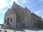
The C. H. Cook Memorial Church.
-
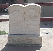
The grave of Charles Cook's son, Franklin wife Annie M. Cook (Coates).
-
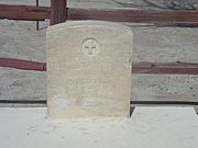
The grave of Mathew B. Juan.
-
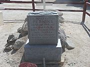
The grave of Confederate Colonel James Patton Perkins.
-
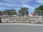
The Matthew B. Juan-Ira H. Hayes Veterans Memorial Park.
-
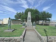
The Pvt. Matthew B. Juan Monument.
-
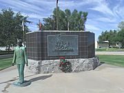
The Ira H. Hayes Monument.
-
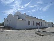
The First Pima Baptist Church a.k.a. "The first Southern Baptist Church".
-
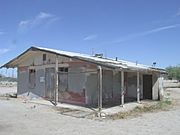
Abandoned early 20th Century house.


_B._Juan.JPG)


Gila River Japanese War Relocation Center
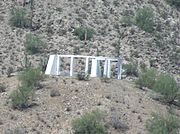
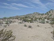
During World War II, the Gila River War Relocation Center was a camp built by the War Relocation Authority (WRA). This camp was used to hold Japanese Americans during the war. The Gila River War Relocation Memorial is located on Indian Route 24 in Sacaton, Arizona. There are also ruins of the camp and concrete foundations that show where buildings once stood.
- Gila River War Relocation Center
-
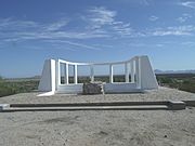
The Gila River War Relocation Center.
-
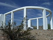
Different view of the Gila River War Relocation Memorial.
-
The Gila River War Relocation Memorial.
-
The Gila River Japanese Relocation Internment Camp ruins.
-
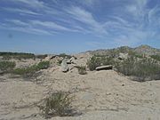
More ruins of the Gila River Japanese Relocation Internment Camp.
-
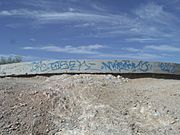
Gila River War Relocation Center concrete slab foundation.


.JPG)


See also
 In Spanish: Sacaton (Arizona) para niños
