Sacate, Arizona facts for kids
Quick facts for kids
Sacate, Arizona
|
|
|---|---|

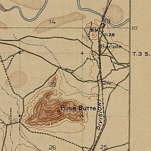
Sacate, Arizona c. 1913 (USGS Maricopa quadrangle, map held at Perry-Castañeda Library)
|
|
| Country | United States |
| State | Arizona |
| County | Pinal |
| Elevation | 1,093 ft (333 m) |
| Time zone | UTC-7 (Mountain (MST)) |
| • Summer (DST) | UTC-7 (MST) |
| ZIP codes |
86326
|
| Area code(s) | 520 |
| FIPS code | 04-61710 |
| GNIS feature ID | 25339 |
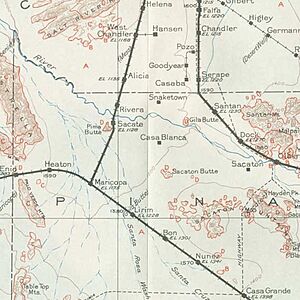
Sacate is a small, historic place in Pinal County, Arizona, United States. It is located about 8 miles north of Maricopa. Sacate sits on the south side of the Gila River, near a landmark called Pima Butte.
This area was once a village for the Pima people. It also became a railroad station and a Catholic mission. Sacate was first called Sacaton Station. In 1904, its name was shortened to Sacate.
Contents
What's in a Name?
The name Sacate, and other similar names nearby, likely came from Spanish words. A Spanish explorer named Francisco Garcés visited this area in 1775–76. He described the local grasslands using the word sácate or sácaton.
Sácate is a Spanish word for grass that animals like horses and cattle eat. Sácaton means tall, thick grass, like reeds, that animals usually don't eat. A place called Sacate was also where the Battle of Pima Butte happened in 1857–58. This battle was between the Yuma and Maricopa Native American groups.
Sacate's Railroad Days
Sacate was originally a station on the Maricopa and Phoenix Railway. This railway line was built in 1887. The Southern Pacific Railroad laid tracks in Arizona between 1879 and 1881. Sacate was part of this important rail network.
In 1934, the Southern Pacific Railroad decided to stop using this particular line. This change affected how people and goods moved through the area.
Life by the Gila River
In the late 1800s, new settlements in Arizona Territory changed the Gila River valley. This disrupted the traditional farming and water systems of the local people. The people of what is now the Gila River Indian Community started selling firewood to make a living.
A local newspaper reported in 1901 that over 30,000 cords of mesquite wood were piled up at Sacaton Station. Over about 12 years, nearly 100,000 acres of mesquite trees were cut down. Many of these trees did not grow back because there wasn't enough water. By 1904, about 2,800 Pima people living east of the railroad were suffering from a severe water shortage. This drought had been going on since 1890.
A guidebook from 1901 described the train journey through this area. It mentioned passing the Gila River and an interesting Native American settlement. Further along, the train crossed an irrigation canal. Beyond that, there were wide plains with sparse plants like greasewood and cactus. Then, the train would speed through cottonwood trees, green alfalfa fields, orchards, and vineyards. It would pass through Tempe and cross a large bridge over the Salt River.
By 1915–16, the area was known as Sacate Siding. It was part of the Arizona Eastern Railway. Sacate Siding did not have its own post office. The only business listed there was Phoenix Wood & Coal Co. In 1917, this company considered buying mesquite beans from Sacaton Reservation sellers. This was an idea in case of food shortages during World War I. They also thought about building a mill to make mesquite flour in large amounts.
Other Pima villages near Sacate around 1921 included Vah-Ki, Bapchule, Casa Blanca, and Sweetwater. All these villages were on the south side of the river, before reaching the Pima "Indian agency" at Sacaton.

A Place of Faith and Learning
In 1936, Sacate had a population of 12 people. Mail was delivered to Maricopa. The closest church with a priest was about 13 miles northwest in Komatke.
A Franciscan friar named Father Antoine ran the St. Francis in the Desert mission at Sacate in 1941. James Stevens, an Apache artist who married a Pima woman, painted murals inside the church at Father Antoine's mission. He also painted murals in several other mission churches nearby.
The Sacate Catholic Day School served the Pima and Papago people of the area. It operated at the mission from 1930 until 1969. In 1965, the priest was Rev. Celestine Chinn. Sadly, James Stevens' murals were destroyed when the church building burned down in 1993. There is also a cemetery in Sacate.
Sacate is considered part of the Gila River Indian Community. This community includes several settlements that need more medical services. Sacate's elevation is about 1,093 feet (333 meters) above sea level.
 | Selma Burke |
 | Pauline Powell Burns |
 | Frederick J. Brown |
 | Robert Blackburn |


