Maricopa, Arizona facts for kids
Quick facts for kids
Maricopa
|
|||||
|---|---|---|---|---|---|

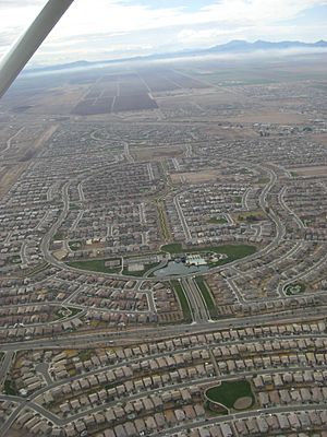
Residential developments dominate the landscape of Maricopa
|
|||||
|
|||||

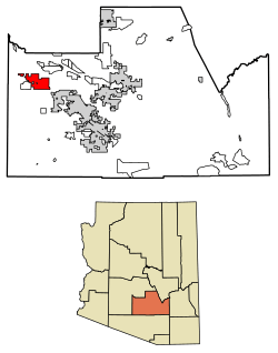
Location of Maricopa in Pinal County, Arizona
|
|||||
| Country | United States | ||||
| State | Arizona | ||||
| County | Pinal | ||||
| Established | 1857 | ||||
| Incorporated | 2003 | ||||
| Government | |||||
| • Type | Council-manager government | ||||
| Area | |||||
| • Total | 42.59 sq mi (110.32 km2) | ||||
| • Land | 42.49 sq mi (110.06 km2) | ||||
| • Water | 0.10 sq mi (0.26 km2) | ||||
| Elevation | 1,201 ft (366 m) | ||||
| Population
(2022)
|
|||||
| • Total | 66,290 | ||||
| • Density | 1,560.13/sq mi (600.89/km2) | ||||
| Time zone | UTC-7 (MST (no DST)) | ||||
| ZIP code |
85138, 85139
|
||||
| Area code(s) | 520 | ||||
| FIPS code | 04-44410 | ||||
| GNIS feature ID | 2411032 | ||||
| Website | https://www.maricopa-az.gov/home | ||||
Maricopa is a city in Pinal County, Arizona, in the Gila River Valley of the United States. As of 2022, it is the largest city in Pinal County, with about 66,290 people living there. Maricopa is known for growing very quickly.
Contents
History of Maricopa
Maricopa has been in three different spots over time. These places were called Maricopa Wells, Maricopaville, and then Maricopa Junction, which is now simply known as Maricopa.
Early Days at Maricopa Wells
The first location, Maricopa Wells, was an oasis with water holes. It was about eight miles north of where Maricopa is today. Several rivers in Arizona helped keep this desert spot full of water.
In the late 1800s, Maricopa Wells was a very important stop for mail and travelers. It was a key station on routes like the San Antonio-San Diego Mail Line. People knew it as a reliable place to get water and food. Local Pima and Maricopa farmers sold supplies to those passing through.
The busiest time for Maricopa Wells was in the 1870s. It provided water and food for travelers going both east-west and north to Phoenix. Roads were built, making it a busy center of activity.
The Railroad and New Locations
Later, a place called Maricopaville grew south and west of the Wells. This happened when a railroad line was being built. In 1879, the Southern Pacific Railroad was building a line from Yuma to Tucson. Another line was planned from Maricopaville to Phoenix.
Maricopaville quickly became a busy town, like a gold rush city. People built hotels, restaurants, and theaters day and night. Some even thought Maricopaville could become the state capital!
However, the railroad line to Phoenix was never built from Maricopaville. Instead, the railroad decided to go through Tempe. So, the town of Maricopaville was moved about three miles east to its current spot in the early 1880s. This new location was better for the Maricopa & Phoenix line. The first train left Maricopa for Phoenix on July 4, 1887. All train travelers going east or west had to stop in Maricopa. If they wanted to go north, they switched to the Maricopa & Phoenix Railroad.
Maricopa Becomes a City
Maricopa officially became a city on October 15, 2003. It was the 88th city in Arizona to be officially formed. Between 2000 and 2010, the city's population grew from 1,040 people to 43,482. This was a huge increase of 4080%!
The city has continued to grow very fast. In 2021, Maricopa had 58,125 people, making it the most populated city in Pinal County. By 2022, the population reached 66,290. This makes Maricopa one of the fastest-growing cities in the United States.
Ak-Chin Indian Community
A part of Maricopa is located within the Ak-Chin Indian Community. This Native American tribe has developed several businesses that help the local economy. These include Harrah's Ak-Chin Casino, a resort, a movie theater, and a golf course. These places are open to everyone and bring visitors from Maricopa and the Phoenix area. The tribe also runs the Ak-Chin Regional Airport and an industrial park.
Geography and Climate
Maricopa is located at 33°3′24″N 112°2′48″W / 33.05667°N 112.04667°W. The city has a total area of about 31.9 square miles (82.6 square kilometers). Most of this area is land.
The land in Maricopa is mostly flat. There are several mountain ranges about 10 to 20 miles away. The city is about 1,190 feet (363 meters) above sea level.
| Climate data for Maricopa, AZ | |||||||||||||
|---|---|---|---|---|---|---|---|---|---|---|---|---|---|
| Month | Jan | Feb | Mar | Apr | May | Jun | Jul | Aug | Sep | Oct | Nov | Dec | Year |
| Record high °F (°C) | 86 (30) |
90 (32) |
100 (38) |
106 (41) |
113 (45) |
122 (50) |
124 (51) |
117 (47) |
113 (45) |
109 (43) |
95 (35) |
84 (29) |
124 (51) |
| Mean daily maximum °F (°C) | 68 (20) |
73 (23) |
79 (26) |
88 (31) |
98 (37) |
107 (42) |
108 (42) |
106 (41) |
102 (39) |
90 (32) |
77 (25) |
67 (19) |
89 (31) |
| Mean daily minimum °F (°C) | 36 (2) |
39 (4) |
44 (7) |
50 (10) |
59 (15) |
68 (20) |
77 (25) |
76 (24) |
68 (20) |
54 (12) |
42 (6) |
35 (2) |
54 (12) |
| Average precipitation inches (mm) | 0.83 (21) |
0.91 (23) |
1.00 (25) |
0.28 (7.1) |
0.17 (4.3) |
0.08 (2.0) |
0.98 (25) |
0.96 (24) |
0.72 (18) |
0.47 (12) |
0.58 (15) |
0.97 (25) |
7.98 (203) |
| Source: The Weather Channel | |||||||||||||
Neighboring Towns and Areas
 |
Goodyear | Gila River Indian Community | Gila River Indian Community |  |
| Ak-Chin Village | Gila River Indian Community | |||
| Palo Verde Mountains | Stanfield | Casa Grande |
People of Maricopa
| Historical population | |||
|---|---|---|---|
| Census | Pop. | %± | |
| 2000 | 1,040 | — | |
| 2010 | 43,482 | 4,081.0% | |
| 2020 | 58,125 | 33.7% | |
| U.S. Decennial Census | |||
In 2010, there were 43,482 people living in Maricopa. The city had 14,359 households and 11,110 families. The population was spread out, with many young people. About 32.5% of the people were under 18 years old. The average age was about 31 years old.
The people in Maricopa come from many different backgrounds. About 70.2% were White, 9.7% Black, 2.0% Native American, and 4.1% Asian. About 24.4% of the population identified as Hispanic or Latino.
In 2009, the average income for a household in the city was about $67,692.
City Services and Transportation
Maricopa has important roads, train services, and other utilities that help the city run smoothly.
Roads and Highways
The main highway serving Maricopa is Arizona State Route 347. This road goes north and south, connecting to Interstate 10 about 14 miles north of the city. Inside Maricopa, this road is called John Wayne Parkway.
Another important road is Arizona State Route 238. It connects Maricopa to the town of Mobile, which is part of Goodyear. This road is also known as Mobile Road.
Train Services

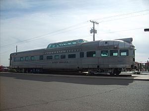
Maricopa is on a major railroad line used by Union Pacific. The city has an Amtrak station, which opened in 2001. This station is the closest train stop for people traveling to or from Phoenix on the Sunset Limited and Texas Eagle trains. There is also a bus service, called Amtrak Thruway, that connects the Maricopa station to Phoenix.
Utilities and Bus Service
Maricopa gets its cable, electricity, natural gas, telephone, and water services from different companies. The city also has its own local bus service called Maricopa Express Transit (MET).
How Maricopa is Governed
Maricopa uses a "Council-Manager" form of government. This means that elected officials, like the Mayor and City Council, work with a professional City Manager. Together, they guide how the city is run.
The Maricopa City Council includes the Mayor and six City Council members. The Mayor is elected for a four-year term, and the City Council members also serve four-year terms. They hold meetings twice a month.
Many groups of citizens help guide the City Council. These groups advise on things like parks, safety, and planning. The city has nine main departments, including the City Manager's Office, Police Department, and Fire Department. More than 250 people work for the city government.
Community Groups
Maricopa has many groups that help the community:
- F.O.R. Maricopa - a local food bank
- Maricopa Gun Club - a local club for gun enthusiasts
- Maricopa Historical Society - an organization that preserves local history
- Maricopa Motorcycle Riders - a local group for motorcycle riders
- Maricopa Seniors - a group for senior citizens
- MomDoc Charities
- Pet Social Worker / Tails of Hope Rescue - a local animal rescue group
- Recycling Association of Maricopa (R.A.M.) - a group for community recycling
- Thunderbird Arena Community Council (TACC) - a group supporting the renovation of the Thunderbird Farms Arena
- Maha Ganpati Temple of Arizona - a Hindu Temple built in the Dravidian style. www.ganapati.org
- The Opportunity Tree - a nonprofit program for children and adults with intellectual and developmental disabilities. [1]
Schools and Colleges
Maricopa has many schools for students of all ages.
Public School Districts
- Maricopa Unified School District
- Mobile Elementary School District
Public Elementary Schools
- Butterfield Elementary School
- Maricopa Elementary School
- Mobile Elementary School
- Pima Butte Elementary School
- Saddleback Elementary School
- Santa Cruz Elementary School
- Santa Rosa Elementary School
Public Middle Schools
- Desert Wind Middle School
- Maricopa Wells Middle School
Public High Schools
- Desert Sunrise High School
- Maricopa High School
Charter Schools
- Leading Edge Academy Maricopa
- Legacy Traditional School-Maricopa Campus
- Sequoia Pathway Academy Maricopa
- A+ Charter Schools
- Heritage Academy Maricopa
Community College
- Central Arizona College
Famous People from Maricopa
- Bristol Palin - daughter of former Alaska governor Sarah Palin, lived in Maricopa for two years.
- Steve Smith - a former state senator, lives in Maricopa.
- Charles Smith (cowboy) - a lawman and friend of Wyatt Earp.
- John Wayne - a famous actor, owned land nearby and visited local places.
See also
 In Spanish: Maricopa (Arizona) para niños
 | Delilah Pierce |
 | Gordon Parks |
 | Augusta Savage |
 | Charles Ethan Porter |


